
Hillcrest is an uptown neighborhood in San Diego, California. The area is located north-northwest of Balboa Park, south of Interstate 8/Mission Valley, with Park Boulevard to the east and First Avenue to the west.

The Arroyo Seco, meaning "dry stream" in Spanish, is a 24.9-mile-long (40.1 km) seasonal river, canyon, watershed, and cultural area in Los Angeles County, California. The area was explored by Gaspar de Portolà who named the stream Arroyo Seco as this canyon had the least water of any he had seen. During this exploration he met the Chief Hahamog-na (Hahamonga) of the Tongva Indians.

North Park is a neighborhood in San Diego, California, United States, as well as a larger "community" as defined by the City of San Diego for planning purposes. The neighborhood is bounded:

Normal Heights is a neighborhood in the mid-city region of San Diego, California.

Barrio Logan is a neighborhood in south central San Diego, California. It is bordered by the neighborhoods of East Village and Logan Heights to the north, Shelltown and Southcrest to the east, San Diego Bay to the southwest, and National City to the southeast. Interstate 5 forms the northeastern boundary. The Barrio Logan Community Plan Area comprises approximately 1,000 acres, of which slightly more than half is under the jurisdiction of the Port of San Diego or the United States Navy rather than the city of San Diego. The community is subject to the California Coastal Act. Though located near the city's central core, it has long been considered part of Southeast San Diego by many locals, being directly southeast of downtown San Diego, and with previous historical records labeling it as part of "Western Southeast San Diego."
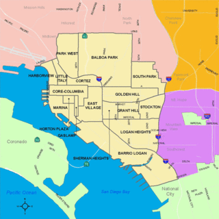
Golden Hill is a neighborhood in San Diego, California. It is located south of Balboa Park, north of Sherman Heights, Grant Hill and Stockton, and east of downtown.
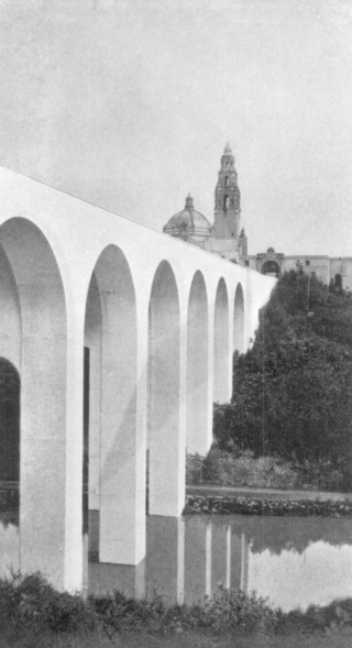
The Cabrillo Bridge is a historic bridge in San Diego, California, providing pedestrian and light automotive access between Balboa Park and the Uptown area of San Diego. It was built for the 1915 Panama–California Exposition. The bridge was nominated for the National Register of Historic Places in 1976 and was named a Local Historic Civil Engineering Landmark by the American Society of Civil Engineers in 1986.
South Park is a neighborhood in San Diego, California, adjacent to the southeast corner of Balboa Park. It stands out in San Diego for its tree-lined streets and walkable business district.

California's 29th congressional district is a congressional district in the U.S. state of California based in the north central San Fernando Valley. The district is represented by Democrat Tony Cárdenas.
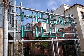
Mission Hills is a neighborhood in San Diego, California, United States. It is located on hills just south of the San Diego River valley and north of downtown San Diego and San Diego International Airport, overlooking downtown, Old Town, and San Diego Bay.

University City (UC) is a community in San Diego, California, located in the northwestern portion of the city next to the University of California, San Diego. The area was originally intended to serve as housing for the faculty of the university, hence the name.

Kensington is a neighborhood of San Diego, California. Its borders are defined by Interstate 15 to the west, Interstate 8 to the north, Fairmount Avenue to the east, and El Cajon Boulevard to the south. Its neighboring communities are Normal Heights to the west, and City Heights to the south. Kensington is part of San Diego City Council District 9. In the United States House of Representatives, Kensington is in California's 53rd congressional district, represented by Democrat Sara Jacobs. Due to redistricting, it will become part of the 51st district after the 2022 congressional election.

Clairemont is a community in San Diego, California, United States. It has a population of about 81,600 residents and an area of roughly 13.3 square miles (34 km2). Clairemont is bordered by Interstate 805 on the east, Interstate 5 to the west, State Route 52 to the north, and the community of Linda Vista to the south. The community of Clairemont can be subdivided into the neighborhoods of North Clairemont, Clairemont Mesa East, Clairemont Mesa West, Bay Park, and Bay Ho.

Cortez Hill is a neighborhood in the northeast part of downtown San Diego, California.
30th Street is a major north–south road in San Diego, California, on the east side of Balboa Park. It connects several of the densest urban communities of downtown San Diego and has a high rate of pedestrian activity. In recent years, 30th Street has become known nationally for its prominent craft beer culture.

Balboa Park is a 1,200-acre (490 ha) historic urban cultural park in San Diego, California. Placed in reserve in 1835, the park's site is one of the oldest in the United States dedicated to public recreational use. The park hosts various museums, theaters, restaurants, and the San Diego Zoo. It is managed and maintained by the Parks and Recreation Department of the City of San Diego.
Shelltown is a neighborhood in San Diego, California, located within Southeast San Diego. It is bordered by National City to the south, Interstate 5 and Barrio Logan to the west, 43rd Avenue to the east, and Gamma Court and the neighborhood of Southcrest to the north. Prior to the 1980s the northern border of Shelltown was National Ave and many residents still consider that the northern border. Naval Base San Diego, an industrial park, and some commercial buildings are located just outside the western border of Shelltown along Main Street.
Marston Hills is a neighborhood within the Hillcrest community of San Diego, California. It is located above the northwestern corner of Balboa Park, and is generally bounded by Sixth Avenue to the west, Pennsylvania Avenue to the north, and Park Boulevard to the east, although some sources give California State Route 163 as the western boundary. The neighborhood is named after George Marston, an early San Diego businessman and philanthropist, whose house and grounds are located in the area.
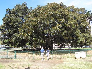
The Moreton Bay fig tree in San Diego's Balboa Park is one of the largest trees in California.

