Hadsel is a municipality in Nordland county, Norway. It is part of the traditional district of Vesterålen. The administrative centre of the municipality is the town of Stokmarknes. Other villages in Hadsel include Fiskebøl, Gjerstad, Grønning, Grytting, Hanøyvika, Hennes, Kaljord, Melbu, Sanden, and Sandnes.

Svolvær is the administrative centre of Vågan Municipality in Nordland County, Norway. It is located on the island of Austvågøya in the Lofoten archipelago, along the Vestfjorden. The 2.37-square-kilometre (590-acre) town has a population (2018) of 4,720 which gives the town a population density of 1,992 inhabitants per square kilometre (5,160/sq mi).

Laupstad is a village in Vågan Municipality in Nordland county, Norway. It is located on the island of Austvågøya at the end of the Austnesfjorden, about 3 kilometres (1.9 mi) north of the village of Liland. The European route E10 highway runs through the village. The mountain Higravstindan lies about 3 kilometres (1.9 mi) east of Laupstad and the boundary with Hadsel Municipality lies just north of the village.

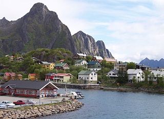
Kabelvåg is a village in Vågan Municipality in Nordland county, Norway. It is located on the southern shore of the island of Austvågøya in the Lofoten archipelago. Kabelvåg lies about 5 kilometres (3.1 mi) to the southwest of the town of Svolvær, the administrative centre of Vågan municipality. The 1.13-square-kilometre (280-acre) village has a population (2018) of 1,883 which gives the village a population density of 1,666 inhabitants per square kilometre (4,310/sq mi).

Løding is a village in the municipality of Bodø in Nordland county, Norway. It is located about 17 kilometres (11 mi) east of the town of Bodø, and is connected to the town by the Tverlandet Bridge. The village is mostly referred to as Tverlandet, which also encompasses the areas Hopen, Vatne, Heggmoen, Mjønes, Vågan, Holand, Skålbunes, Elstad, Oddan, Allmenningen, Godøynes (Gaunes), and Naurstad, all of which lies around the village.

Baugevatnet is a lake that lies in Tysfjord Municipality in Nordland county, Norway. The 4.99-square-kilometre (1.93 sq mi) lake is located about 25 kilometres (16 mi) east of the village of Kjøpsvik and just 1.5 kilometres (0.93 mi) northwest of the border with Sweden. The lake Båvrojávrre lies about 3 kilometres (1.9 mi) to the southwest and the lake Langvatnet lies about the same distance to the north.
Faulvatnet (Norwegian) or Låddejávrre (Lule Sami) is a lake that lies in the municipality of Sørfold in Nordland county, Norway. The 7.24-square-kilometre (2.80 sq mi) lake is located about 15 kilometres (9.3 mi) north of the village of Straumen, just west of Rago National Park. The water flows out into the Sleipdalselva river and the water is used for power generation at the Lakshola hydroelectric power station.
Markavatnet or Markvatnet is a lake that lies in the municipality of Meløy in Nordland county, Norway. The 2.28-square-kilometre (0.88 sq mi) lake is located about 4 kilometres (2.5 mi) east of the village of Reipå and the same distance north of the municipal centre of Ørnes. The lake Lysvatnet lies about 3 kilometres (1.9 mi) to the east of Markavatnet.
Nedre Fiplingvatnet (Norwegian) or Fijhpelogkoe (Southern Sami) is a lake that lies in the municipality of Grane in Nordland county, Norway. The 10.5-square-kilometre (4.1 sq mi) lake lies just west of Børgefjell National Park. The village of Leiren is located about 4 kilometres (2.5 mi) north of the lake.
Liland is a village in Vågan Municipality in Nordland county, Norway. It is located on the island of Austvågøya, about 3 kilometres (1.9 mi) south of the village of Laupstad on the eastern bank of the Austnesfjorden. The mountain Higravtindan lies about 3 kilometres (1.9 mi) northeast of Liland.

Skrova is a small island group and village area in Vågan Municipality in Nordland county, Norway. The 2.5-square-kilometre (0.97 sq mi) Skrova island group in the Lofoten archipelago, about 9 kilometres (5.6 mi) southeast of the town of Svolvær. It is located in the Vestfjorden, south of the islands of Austvågøya, Litlmolla, and Stormolla. The largest island in the group is Storskrova and the island of Heimskrova is where most of the population is located. The six main inhabited islands in the group are all interconnected by a small bridge and several man-made causeways.

Austvågøya is the northeasternmost of the larger islands in the Lofoten archipelago in Nordland county, Norway. It is located between the Vestfjorden and the Norwegian Sea. The island of Vestvågøya lies to the southwest and the large island of Hinnøya to the northeast. In 2017, island had about 9,000 residents.
Higravtindan or Higravstindan is the tallest mountain on the island of Austvågøya in the Lofoten archipelago in Nordland county, Norway. It is located on the border of Hadsel Municipality and Vågan Municipality. The village of Laupstad and the European route E10 highway are located about 3 kilometres (1.9 mi) west of the mountain and the village of Liland is located about 3 kilometres (1.9 mi) southwest of the mountain. There is a glacier located on the east side of the mountain.

Henningsvær is a fishing village in Vågan Municipality in Nordland county, Norway. It is located on several small islands off the southern coast of the large island of Austvågøya in the Lofoten archipelago. The village is located about 20 kilometres (12 mi) southwest of the town of Svolvær. Henningsvær is connected to the rest of Vågan via the Henningsvær Bridges. The village is mostly located on the islands of Heimøya and Hellandsøya.
Gravermarka is a small village in Vågan Municipality in Nordland county, Norway. It is located on the western side of the island of Austvågøya in the Lofoten archipelago. The village of Sydalen lies about 1.5 kilometres (0.93 mi) southeast of the village.

Stormolla is an island in Vågan Municipality in Nordland county, Norway. It is located in the Lofoten islands, south of the large islands of Austvågøya and Hinnøya and northeast of the smaller islands of Litlmolla and Skrova. The highest point on the island is the 751-metre (2,464 ft) tall mountain Heggedalstinden.

Gimsøy Church is a parish church of the Church of Norway in Vågan Municipality in Nordland county, Norway. It is located in the village of Gimsøysand on the island of Gimsøya. It is the main church for the Gimsøy og Strauman parish which is part of the Lofoten prosti (deanery) in the Diocese of Sør-Hålogaland. The white, wooden church was built in a long church style in 18 by the architect Carl J. Bergstrøm. The church seats about 300 people.
Sanden or Hadselsand is a village in Hadsel Municipality in Nordland county, Norway. The village is located along the Hadselfjorden on the northern part of the island of Austvågøya, not far from the border with Vågan Municipality and about 10 kilometres (6.2 mi) west of the village of Fiskebøl. Sand Church is located in Sanden.

Gimsøy is a former municipality in Nordland county, Norway. The 187-square-kilometre (72 sq mi) municipality existed from 1856 until its dissolution in 1964. It was located in the northwestern part of what is now Vågan Municipality. The municipality consisted mainly of the island of Gimsøya as well as the western part of the larger neighboring island of Austvågøya. The municipalities also included 407 other small islands as well has hundreds of little islets and skerries, all of which are located in the Lofoten archipelago. The administrative centre was located at the village of Gimsøysand, where the Gimsøy Church is located.