Related Research Articles
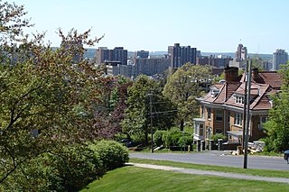
Syracuse is a city in and the county seat of Onondaga County, New York, United States. It is the fifth-most populous city in the state of New York following New York City, Buffalo, Yonkers and Rochester.

Lysander is a town in Onondaga County, New York, United States. The population was 21,759 at the 2010 census. The town was named after Lysander, a Spartan military leader, by a clerk interested in the classics. The town is in the northwestern corner of Onondaga County and is located northwest of Syracuse. Much of the town is a suburb of Syracuse.

Van Buren is a town located in Onondaga County, New York, United States. As of the 2010 census, the town had a population of 13,185. The town is named after then-Senator Martin Van Buren, who would later become the eighth president of the United States.

Onondaga Lake is a lake in Central New York, immediately northwest of and adjacent to Syracuse, New York. The southeastern end of the lake and the southwestern shore abut industrial areas and expressways; the northeastern shore and northwestern end border a series of parks and museums.
Interstate 690 (I-690) is an auxiliary Interstate Highway that extends for 14.19 miles (22.84 km) through the vicinity of Syracuse, New York, in the United States. It is a spur of I-90 that travels southeast from Thruway exit 39 in Van Buren to I-481 in DeWitt. In between, I-690 passes through the western suburbs of Syracuse before heading east through the city itself, where it meets I-81 in downtown Syracuse. The expressway continues northwest of the Thruway as New York State Route 690 (NY 690).

The Seneca River flows 61.6 miles (99.1 km) through the Finger Lakes region of Upstate New York in the United States. The main tributary of the Oswego River – the second largest river flowing into Lake Ontario – the Seneca drains 3,468 square miles (8,980 km2) in parts of fourteen New York counties. The Seneca flows generally east, and is wide and deep with a gentle gradient. Much of the river has been channelized to form part of the Erie Canal.
New York State Route 48 (NY 48) is a 28.20-mile (45.38 km) north–south state highway in Central New York in the United States. The southern terminus of the route is located at Interstate 690 (I-690) exit 3 near the interchange between I-690 and the New York State Thruway (I-90) in Van Buren, northwest of Syracuse. The northern terminus is located at an intersection with NY 104 in Oswego. In between, NY 48 passes through the riverside communities of Baldwinsville and Fulton and runs alongside both the Seneca River and Oswego River. For most of its route, NY 48 serves as an alternate route of NY 481. The routes share similar alignments along the Oswego River from the Syracuse area to Oswego, with NY 481 following the eastern riverbank between the two locations.
New York State Route 174 (NY 174) is a state highway in Onondaga County, located in Central New York, in the United States. The highway is 16.7 miles (26.9 km) long and passes through mostly rural regions. Route 174 begins at an intersection with NY 41 in Borodino, a hamlet of Spafford. It heads generally northward for most of its length, except for short distances in the villages of Marcellus and Camillus. The route ends at a junction with NY 5 west of Camillus, at the west end of the Route 5 Camillus bypass. Route 174 is located along a large mapped sedimentary bedrock unit, known as the Marcellus Formation. The formation is named for an outcrop found near the town of Marcellus, New York, during a geological survey in 1839.
New York State Route 175 is an east–west state highway in Onondaga County, New York, in the United States. The 15.46-mile (24.88 km) route begins at an intersection with U.S. Route 20 (US 20) east of the village of Skaneateles and passes through the village of Marcellus before ending at a junction with US 11 in Syracuse. The highway was designated in the 1930 renumbering of state highways in New York.
New York State Route 370 (NY 370) is an east–west state highway in Central New York in the United States. It extends for about 35 miles (56.33 km) from an intersection with NY 104 and NY 104A south of the Wayne County village of Red Creek to a junction with U.S. Route 11 (US 11) in the Onondaga County city of Syracuse. The western and central portions of the route pass through mostly rural areas; however, the eastern section serves densely populated areas of Onondaga County, including the villages of Baldwinsville and Liverpool. NY 370 also passes through Cayuga County, where it connects to NY 34, a major north–south highway in Central New York.
New York State Route 690 (NY 690) is a state highway in Central New York in the United States. NY 690's southern terminus is at an interchange with the New York State Thruway and I-690 in Van Buren. The northern terminus is at an intersection with NY 48 and NY 631 in Lysander. NY 690 serves the northwest suburbs of Syracuse and Onondaga County. It also provides a link to routes that run into the populated areas of Oswego County, because its northern terminus is just a few miles shy of the county line.

William Martin Beauchamp was an American ethnologist and Episcopal clergyman. He published several works on the archeology and ethnology of the Haudenosaunee (Iroquois) in New York.

Plainville is a hamlet on NY Route 370, approximately 4.5 miles west of Baldwinsville in Onondaga County, New York, United States.

New York State Route 631 (NY 631) is a north–south state highway in Onondaga County, New York, in the United States. It serves as a bypass around the village of Baldwinsville, extending for just over 5 miles (8.0 km) from an intersection with NY 370 in the southeastern part of the village to a junction with NY 48 and NY 690 just north of Baldwinsville in the town of Lysander. The route has a short overlap with NY 31 east of the village. Most of the route is two lanes wide and passes through rural areas around the edge of Baldwinsville, while a part near the Lysander community of Radisson is four lanes wide and serves residential and commercial neighborhoods.
New York State Route 57 (NY 57) was a north–south state highway in the central portion of New York in the United States. It extended for 33.45 miles (53.83 km) from an intersection with U.S. Route 11 (US 11) just north of downtown Syracuse to a junction with NY 104 six blocks from the Lake Ontario shoreline in Oswego. North of Liverpool, NY 57 was routed along the eastern bank of the Seneca and Oswego Rivers. It passed through several riverside communities, including the village of Phoenix and the city of Fulton. The route largely paralleled NY 48, which follows the western bank of the waterway between Van Buren and Oswego via Baldwinsville.
The story of the city of Syracuse began with the land which was covered with swamps and bogs, and with a large forest surrounding a clear, freshwater lake located in the northeast corner of the Finger Lakes Region. The land around the present day city was originally the home of the Haudensaunee, or the Onondaga Nation. They were members of the Iroquois Confederacy, which spanned most of Upstate New York.
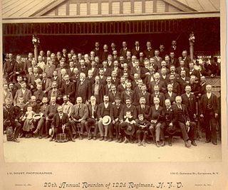
The 122nd New York Infantry Regiment known as the "Onondagas", was an infantry regiment in the Union Army during the American Civil War.
Syracuse is a city in Central New York sited on the former lands of the Onondaga Nation. Officially incorporated as a village in 1825, it has been at a major crossroads over the last two centuries, first of the Erie Canal and its branch canals, then on the railway network. The city grew on the back of its salt and chemical industries, and later as a center of manufacturing and engineering. Although its industries have dwindled, the city has remained the economic and educational hub of Central New York, a region with over a million inhabitants; the population of the city, though, has been in decline since peaking in the 1950s.
The Onondaga County Public Library (OCPL) is a consolidated county library with more than 30 branches in Onondaga County. Its headquarters are in Syracuse, New York. It was established in 1976 as a result of the merger of the Onondaga Library System and Syracuse Public library.
Radisson is a planned community and census-designated place (CDP) in the town of Lysander, Onondaga County, New York, United States. It was first listed as a CDP prior to the 2020 census.
References
- ↑ "Certification Review" (PDF). Syracuse Metropolitan Transportation Council, November 2002. Retrieved February 19, 2011.
- ↑ Polston, Jeff (2010). "JeffPo's Empire State Railroad Lantern Page". JeffPo's Universe. Retrieved March 3, 2010.
- ↑ Beauchamp, Rev. William Martin (1908). Past and present of Syracuse and Onondaga county, New York (Volume 1). New York: S. J. Clarke Publishing Co., 1908. Retrieved January 14, 2012.