Related Research Articles

Surveying or land surveying is the technique, profession, art, and science of determining the terrestrial or three-dimensional positions of points and the distances and angles between them. A land surveying professional is called a land surveyor. These points are usually on the surface of the Earth, and they are often used to establish maps and boundaries for ownership, locations, such as the designed positions of structural components for construction or the surface location of subsurface features, or other purposes required by government or civil law, such as property sales.

An archaeological site is a place in which evidence of past activity is preserved, and which has been, or may be, investigated using the discipline of archaeology and represents a part of the archaeological record. Sites may range from those with few or no remains visible above ground, to buildings and other structures still in use.
Survey may refer to:

Monte Albán is a large pre-Columbian archaeological site in the Santa Cruz Xoxocotlán Municipality in the southern Mexican state of Oaxaca. The site is located on a low mountainous range rising above the plain in the central section of the Valley of Oaxaca, where the latter's northern Etla, eastern Tlacolula, and southern Zimatlán and Ocotlán branches meet. The present-day state capital Oaxaca City is located approximately 9 km (6 mi) east of Monte Albán.
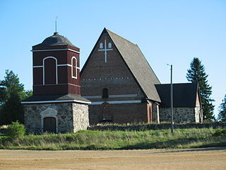
Hattula is a municipality of Finland. It is part of the Tavastia Proper region and until 2010 it was located in the province of Southern Finland. Hattula is almost completely surrounded by Hämeenlinna, only in the north it shares the border with Valkeakoski and Pälkäne on the Pirkanmaa region side.

The Longshanculture, also sometimes referred to as the Black Pottery Culture, was a late Neolithic culture in the middle and lower Yellow River valley areas of northern China from about 3000 to 1900 BC. For a more accurate location of archeological sights found and comprehensive map, please see https://www.google.com/maps/d/u/0/edit?mid=1eRLw1s2FOy2bRcfHdU16faBYOoKixsar&usp=sharing.The first archaeological find of this culture took place at the Chengziya Archaeological Site in 1928, with the first excavations in 1930 and 1931. The culture is named after the nearby modern town of Longshan in Zhangqiu, Shandong. The culture was noted for its highly polished black pottery. The population expanded dramatically during the 3rd millennium BC, with many settlements having rammed earth walls. It decreased in most areas around 2000 BC until the central area evolved into the Bronze Age Erlitou culture. The Longshan culture has been linked to the early Sinitic.

In archaeology, survey or field survey is a type of field research by which archaeologists search for archaeological sites and collect information about the location, distribution and organization of past human cultures across a large area. Archaeologists conduct surveys to search for particular archaeological sites or kinds of sites, to detect patterns in the distribution of material culture over regions, to make generalizations or test hypotheses about past cultures, and to assess the risks that development projects will have adverse impacts on archaeological heritage. The surveys may be: (a) intrusive or non-intrusive, depending on the needs of the survey team and; (b) extensive or intensive, depending on the types of research questions being asked of the landscape in question. Surveys can be a practical way to decide whether or not to carry out an excavation, but may also be ends in themselves, as they produce important information about past human activities in a regional context.

In geography, statistics and archaeology, a settlement, locality or populated place is a community in which people live. The complexity of a settlement can range from a small number of dwellings grouped together to the largest of cities with surrounding urbanized areas. Settlements may include hamlets, villages, towns and cities. A settlement may have known historical properties such as the date or era in which it was first settled, or first settled by particular people.

Pajaral, otherwise known as El Pajaral, is the modern name for a mid-sized ruined city of the pre-Columbian Maya archaeological site located to the south of the San Pedro Martir river in the Petén department of Guatemala. The name El Pajaral was coined by archaeologist Ian Graham, who discovered the site in the 1970s, and refers to the numerous birds he encountered there during his survey.

The Wesley Butler Archeological District is a historic district composed of a group of archaeological sites in the southwestern corner of the U.S. state of Ohio. Located south of Elizabethtown, the district comprises three Native American mounds and the site of a Native American village, spread out over an area of 40 acres (16 ha). Although the mounds are built atop part of the village site, they are not contemporaneous: the mounds were built by Woodland peoples, but the village dates from the far older Archaic period.

Tel Shimron is an archaeological site and nature reserve in the Jezreel Valley.

Talianki is an archaeological site near the village of the same name in Cherkasy Oblast, Ukraine. It was the location of a large Cucuteni-Trypillian settlement dating to around 3850–3700 BC, currently the largest known settlement in Neolithic Europe. The settlement, built on a bluff between the Tal'ianki River and a smaller stream, was made up of ovular, concentric rows of interconnected buildings. Built on top of the older Cucuteni-Trypillian settlement are the remains of some Yamnaya culture tumuli dating to the middle of the 3rd millennium BC, as well as some graves from the late Bronze Age.
The Bieker-Wilson Village Site is an archaeological site in the far southeastern section of the U.S. state of Illinois. Inhabited during multiple periods over more than five hundred years, the village has been designated a historic site.

Mound Hill is an archaeological site in the Bluegrass region of the U.S. state of Kentucky. Located north of Winchester in far northern Clark County, the site is part of a group of Indian mounds lining Stoner Creek, although by far the largest of the group. The mound has frequently attracted attention from mapmakers and other surveyors, due to its large size; it was measured at 240 feet (73 m) (circumference) and 20 feet (6.1 m) (height) by an 1884 survey, which pronounced it a "romantic sight" due to its hilltop location between Stoner Creek and Pretty Run. The surveyors suggested that its linear shape with a central depression might have been the result of erosion or of the construction of multiple mounds that were later merged into one. It lies approximately 0.5 miles (0.80 km) west of the rest of the group, which occupies the summit of a narrow ridgeline known as the "Devil's Backbone." Digging at these mounds, which were seemingly related to Mound Hill, produced artifacts such as pottery and a pipe, as well as numerous stone box graves.

The Carson Mounds,, also known as the Carson Site and Carson-Montgomery- is a large Mississippian culture archaeological site located near Clarksdale in Coahoma County, Mississippi in the Yazoo Basin. Only a few large earthen mounds are still present at Carson to this day. Archaeologists have suggested that Carson is one of the more important archaeological sites in the state of Mississippi.

Original Maryborough Town Site is a heritage-listed archaeological site at Russell Street, Maryborough, Fraser Coast Region, Queensland, Australia. It was added to the Queensland Heritage Register on 4 September 2007.
Citico Town and Mound was a major center of the Coosa confederacy, at the mouth of Citico Creek in the area of what is now Chattanooga, Tennessee. It was second in size to Etowah at the time of Hernando de Soto's march through the area in 1540 ce. In archaeological terms it is considered as part of the 'Dallas Phase' of Mississippian/Muscogee culture, c. 1300–1600 ce. For the muskogean version and origin of the name, see "Satapo." Isaac H. Bonsall photographed the site during the American Civil War era in 1864 when it was part of a garden for convalescent Union soldiers.

Old Marulan Town is a heritage-listed former townscape at Marulan, Goulburn Mulwaree Council, New South Wales, Australia. It is the site of the original Marulan township prior to the moving of the village in the 1860s in the wake of the Main Southern railway bypassing the original town. It is also known as Mooroowoolen. It was built from 1835 to 1867. It was added to the New South Wales State Heritage Register on 2 April 1999.

Bestansur is a Neolithic tell, or archaeological settlement mound, located in Sulaimaniyah province, Kurdistan Regional Government, Iraq in the western Zagros foothills. The site is located on the edge of the Shahrizor Plain, 30 km to the south-east of Sulaimaniyah. It is on the UNESCO World Heritage Tentative List.
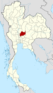
The Khao Sai On site is an archaeological site located in the Lopburi Province of central Thailand; findings at the site indicate metalworking dating as far back as the 1st millennium B.C.E in the South-Eastern Asian region. Archaeologists began excavating the site in 1988, and excavations of the site have continued over the years, with the last analysis of the site occurring in 2007. Excavations of the site have given archaeologists an insight into many aspects of the lives people living in the area such as their burial practices and their metalworking. The site serves as an important center for researching the early metalworking activities of Southeast Asia, and the artifacts discovered at the site display the importance of copper to the ancient people of the Khao Sai On site.
References
Conrad Phillip KOTTAK. Windows on Humanity Chapter 2, page 28–29.
- ↑ "Systematic Sampling Survey". SurveySparrow. 2022-01-07. Retrieved 2022-02-08.