Odda (help·info) is a municipality in Hordaland county, Norway. The municipality is located in southeastern Hordaland county, surrounding the southern end of the Sørfjorden. The administrative centre is the town of Odda, which is also the main commercial and economic centre of the entire Hardanger region. Other villages in the municipality include Botnen, Eitrheim, Håra, Røldal, Seljestad, Skare, and Tyssedal.

Arna is a borough in the city of Bergen in Hordaland county, Norway. Arna is one of 8 boroughs in Bergen. It encompasses the northeastern part of the municipality of Bergen. Arna was merged into the city of Bergen in 1972. Prior to that time, it was the separate municipality of Arna. The main population centres in the borough are the villages of Indre Arna, Ytre Arna, and Espeland.
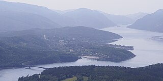
Terråk is the administrative centre of the municipality of Bindal in Nordland country, Norway. The village is located in the eastern part of the municipality, along the shore of the Sørfjorden arm of the Bindalsfjorden. The nearby Vassås Bridge connects Terråk to the village of Vassås just to the north.
Vegår is a lake in the municipality of Vegårshei in Aust-Agder county, Norway. The 17.7-square-kilometre (6.8 sq mi) lake is located about 3 kilometres (1.9 mi) north of the municipal center of Myra and about 12 kilometres (7.5 mi) east of the village of Åmli in the neighboring municipality of Åmli.

Inndyr is the administrative centre of the municipality of Gildeskål in Nordland county, Norway. The village is located on the mainland part of the municipality, about 6 kilometres (3.7 mi) north of Norwegian County Road 17. The village lies along the Sørfjorden and it looks out to the west over the nearby islands of Fugløya, Fleina, and Femris.

Oldervika or Oldervik is a village in the municipality of Rødøy in Nordland county, Norway. The village is located on the eastern shore of the Sørfjorden, just north of the village of Sørfjorden. Although it is located on the mainland, there are no road connections to the rest of Norway. It has a ferry connection to Kilboghamn to the west and Jektvika to the north.
Sørfjorden is a 30-kilometre (19 mi) long fjord in Hordaland county, Norway. The fjord flows around the west and south sides of the island of Osterøy, going through the municipalities of Osterøy, Bergen, and Vaksdal. The fjord begins at the village of Vaksdal where the Veafjorden flows into the Sørfjorden, it then heads west and then north before emptying into the Osterfjorden. The fjord flows past the following villages: Bruvik, Vaksdal, Hausvik, Garnes, Ytre Arna, Hylkje, Breistein, Valestrandfossen, Steinstø and Hamre.
Sørfjorden or Sørfjord is the name of several fjords on the coast of Norway.

Haus or Hausvik is a village in Osterøy municipality in Hordaland county, Norway. The village is located on the southwestern coast of the island of Osterøy along the Sørfjorden. The village lies across the Sørfjorden from the villages of Ytre Arna and Garnes. The village of Valestrandfossen lies about 7 kilometres (4.3 mi) north along the fjord. The 0.38-square-kilometre (94-acre) village has a population (2013) of 619, giving the village a population density of 1,629 inhabitants per square kilometre (4,220/sq mi).

Valestrandfossen or Valestrandsfossen is a village in Osterøy municipality, Hordaland county, Norway. The village sits along the Sørfjorden on the western coast of the island of Osterøy, about 6 kilometres (3.7 mi) west of the municipal centre of Lonevåg and about 7 kilometres (4.3 mi) south of the village of Hamre where Hamre Church is located. Valestrandfossen has shops, a gas station, primary school, hairdressers, pubs, and Lerøy Fossen AS, the world's largest trout smokehouse.
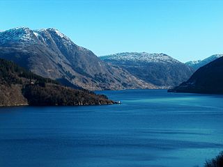
Sørfjorden is a 38-kilometre (24 mi) long fjord that is one of the innermost branches of the main Hardangerfjorden in Hordaland county, Norway. It is the longest arm that branches off of the Hardangerfjord. Sørfjorden stretches from just north of the village of Kinsarvik straight south to the industrial town of Odda. The Folgefonna glacier and Folgefonna National Park are located just to the west of the fjord and the Hardangervidda mountain plateau lies to its east.
Bindalsfjorden is a fjord in the southern part of Nordland county, Norway. The fjord is mostly located in the municipality of Bindal with a small part in neighboring Sømna municipality. The 71-kilometre (44 mi) long fjord begins near the villages of Terråk and Vassås where the Sørfjorden and Tosenfjorden join together. It then flows northwest past Bindalseidet and then southwest past the village of Holm before the mouth of the fjord by the island of Austra.

Melfjorden is a fjord in the municipality of Rødøy in Nordland county, Norway. It is located on the Arctic Circle. The 33-kilometre (21 mi) long fjord goes from the village of Melfjordbotn in the east to its mouth in the Rødøyfjorden near the island of Rangsundøya. There are two fjord arms that branch off the main fjord: Nordfjorden flows to the north into the Saltfjellet–Svartisen National Park and Sørfjorden to the south past the villages of Sørfjorden and Kilboghavn.
Sørfjorden Church is a parish church of the Church of Norway in Rødøy Municipality in Nordland county, Norway. It is located in the village of Sørfjorden on the mainland in the southern part of the municipality. It is one of the churches in the Rødøy parish which is part of the Nord-Helgeland prosti (deanery) in the Diocese of Sør-Hålogaland. The white, wooden church was built in a long church style in 1916 by the architect O.M. Olsen. The church seats about 230 people.
Sørfjorden Chapel is a chapel of the Church of Norway in Gildeskål Municipality in Nordland county, Norway. It is located in the village of Sørfinnset. It is an annex chapel in the Gildeskål parish which is part of the Bodø domprosti (deanery) in the Diocese of Sør-Hålogaland, although the chapel building is not owned by the parish, it is privately owned by the local residents of the Sørfjorden farms. The white, wooden chapel was built in a long church style in 1927. The chapel seats about 300 people. The church is used for worship services about four times each year.
Sørfinnset is a village in the municipality of Gildeskål in Nordland county, Norway. It is located on the mainland, south of the vilalge of Inndyr and east of the village of Storvika. Norwegian County Road 17 passes by 2 kilometres (1.2 mi) south of the village. Sørfjorden Chapel is located in the village.

Ullsfjorden (Norwegian) or Moskavuotna (Northern Sami) is a fjord in Troms county, Norway. The fjord runs through the municipalities of Tromsø, Karlsøy, and Lyngen. The 75-kilometre (47 mi) fjord flows from the village of Sjøvassbotn northwards along the west side of the Lyngen Peninsula. The Kjosen fjord branches off to the east side and the Grøtsundet strait branches off to the west. The islands of Reinøya and Karlsøya lie along the western side of the fjord. The southern part of the Ullsfjorden is also known as Sørfjorden. The area surrounding the Ullsfjorden was part of the municipality of Ullsfjord for about 60 years during the 20th century.

Lofthus is a village in the municipality of Ullensvang, which is located in the Hardanger region of Hordaland county, Norway. The village lies along the eastern shore of the Sørfjorden, along Norwegian National Road 13. Lofthus is located about 10 kilometres (6.2 mi) south of the village of Kinsarvik and about 30 kilometres (19 mi) north of the town of Odda. The 0.67-square-kilometre (170-acre) village of Lofthus has a population (2013) of 556, giving the village a population density of 830 inhabitants per square kilometre (2,100/sq mi).

Søndeledfjorden is a fjord in Risør municipality in Aust-Agder county, Norway. The 15-kilometre (9.3 mi) long fjord begins at the village of Søndeled and flows east into the Skaggerak. The large island of Barmen sits in the middle of the fjord, effectively separating it into two fjords known as the Nordfjorden in the north and the Sørfjorden in the south. At the western end of Barmen, the Nordfjorden and Sørfjorden reconnect in an area known as the Rødsfjorden. There are many islands at the mouth of the fjord as well as in the fjord itself.