Vaksdal (help·info) is a municipality in the county of Hordaland, Norway. It is located in the traditional district of Nordhordland. The administrative centre is the village of Dalekvam. Other villages in Vaksdal include Dalegarden, Flatkvål, Helle, Nesheim, Stamneshella, Stanghelle, and Vaksdal.

Arna is a borough in the city of Bergen in Hordaland county, Norway. Arna is one of 8 boroughs in Bergen. It encompasses the northeastern part of the municipality of Bergen. Arna was merged into the city of Bergen in 1972. Prior to that time, it was the separate municipality of Arna. The main population centres in the borough are the villages of Indre Arna, Ytre Arna, and Espeland.

Nordhordland is a traditional district in the western part of Norway. The district consists of the northern portion of Hordaland county, north of the city of Bergen. It includes the municipalities Austrheim, Fedje, Lindås, Masfjorden, Meland, Modalen, Osterøy, Radøy and Vaksdal. The district roughly corresponds to the Nordhordland prosti, a Church of Norway deanery and to the municipalities in the Nordhordland District Court. Historically, the municipality of Gulen in Sogn og Fjordane county to the north was included in the district.

Knarvik is the administrative centre of the municipality of Lindås in Hordaland county, Norway. The 3.18 km2 (790-acre) village has a population (2013) of 5207, giving the village a population density of 1,637/km2 (4,240/sq mi). This makes it the largest settlement in the whole Nordhordland district of Hordaland. The village is located on the mainland, about 20 km (12 mi) straight north of the city at the confluence of four fjords: Osterfjorden, Sørfjorden, Salhusfjorden, and the Radfjorden. The village of Isdalstø lies immediately north of Knarvik.

Bruvik is a former municipality in Hordaland county, Norway. The municipality existed from 1870 until 1964. Upon its dissolution in 1964, the municipality covered 391 square kilometres (151 sq mi) on both sides of the Veafjorden, the innermost part of the Sørfjorden, including the southeastern part of the island of Osterøy. The administrative centre of the municipality was the village of Bruvik where Bruvik Church is located.

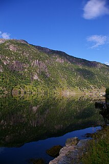
Stamneshella or Stamnes is a village in Vaksdal municipality, Hordaland county, Norway. It is located along the northern part of the Veafjorden, at the entrance to the Bolstadfjorden. The village is an old church site, with records showing a church in this village dating back to the early 14th century. The present Stamnes Church was built in 1861. The village also has a shop, a daycare centre, and a preschool. There a small bridge over the Bolstadfjorden on the eastern end of the village. It connects to a small residential area on the other side of the fjord that is surrounded by mountains and the fjord. About 1 kilometre (0.62 mi) northwest of the village lies the Kallestadsundet Bridge, which connects the mainland to the island of Osterøy, across the Veafjorden.
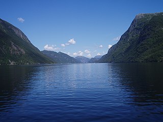
Osterfjorden is a fjord in Hordaland county, Norway. The fjord is one of three fjords surrounding the island of Osterøy. The fjord runs along the municipal border of Lindås and Osterøy municipalities. The fjord begins at the Romarheimsfjorden and flows to the west for 27 kilometres (17 mi) before ending near the village of Knarvik at the confluence of four fjords: Osterfjorden, Radfjorden, Sørfjorden, and Salhusfjorden. The Osterfjorden is generally about 1 to 3 kilometres wide and the deepest point in the fjord reaches a depth of 639 metres (2,096 ft) below sea level.

Haus or Hausvik is a village in Osterøy municipality in Hordaland county, Norway. The village is located on the southwestern coast of the island of Osterøy along the Sørfjorden. The village lies across the Sørfjorden from the villages of Ytre Arna and Garnes. The village of Valestrandfossen lies about 7 kilometres (4.3 mi) north along the fjord. The 0.38-square-kilometre (94-acre) village has a population (2013) of 619, giving the village a population density of 1,629 inhabitants per square kilometre (4,220/sq mi).
Lonevåg is the administrative centre of Osterøy municipality in Hordaland county, Norway. The village is located on the northern coast of the island of Osterøy, at the end of the 5-kilometre (3.1 mi) long Lonevågen fjord, which branches off the main Osterfjorden. The 0.92-square-kilometre (230-acre) village has a population (2013) of 816, giving the village a population density of 887 inhabitants per square kilometre (2,300/sq mi). There are some shops and some small industry in the village.

Valestrandfossen or Valestrandsfossen is a village in Osterøy municipality, Hordaland county, Norway. The village sits along the Sørfjorden on the western coast of the island of Osterøy, about 6 kilometres (3.7 mi) west of the municipal centre of Lonevåg and about 7 kilometres (4.3 mi) south of the village of Hamre where Hamre Church is located. Valestrandfossen has shops, a gas station, primary school, hairdressers, pubs, and Lerøy Fossen AS, the world's largest trout smokehouse.

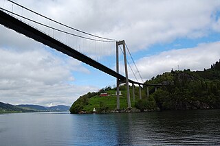
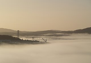
The Kallestadsundet Bridge is a bridge over the Veafjorden in Vaksdal municipality in Hordaland county, Norway. The 200-metre-long (660 ft) bridge links the mainland part of Vaksdal municipality to the part that lies on the island of Osterøy. The bridge lies about 1 kilometre (0.62 mi) northwest of the village of Stamneshella. The bridge was opened in 1985 and it was the first bridge to connect Osterøy island to the mainland. In 1997, the Osterøy Bridge was opened for traffic, as the second bridge to Osterøy island.
Salhusfjorden is a 4-kilometer (2.5 mi) long fjord and sound between the municipalities of Bergen and Meland in Hordaland county, Norway. To the west, it starts between Salhus and Frekhaug, where the Byfjorden meets the Herdlefjorden. To the east, the fjord ends between Knarvik and Hordvikneset, where the Osterfjorden runs northeast, the Sørfjorden runs southeast, and the Radfjorden runs north. The fjord is up to 500 meters (1,600 ft) deep. It acts as one of the borders between the districts of Midhordland to the south and Nordhordland to the north. The islands of Holsnøy and Flatøy lie along the northern side of the fjord.
Lonevågen is a small fjord arm flowing south off of the Osterfjorden in Hordaland county, Norway. The 5-kilometre (3.1 mi) long fjord is up to 500 metres (1,600 ft) wide. The fjord cuts into the island of Osterøy in the municipality of Osterøy. The village of Lonevåg, the administrative center of Osterøy municipality, is located at the end of the fjord.
Romarheimsfjorden is a fjord in Hordaland county, Norway. The fjord flows through the municipalities of Modalen, Lindås, and Osterøy. The western end of the fjord lies near the island of Hokøy where the fjord flows in to the Osterfjorden on its way out to sea. The fjord extends eastward from Hokøy for 11 kilometres (6.8 mi) along the border of Lindås and Osterøy before entering Modalen where it continues to the Mostraumen, a 60-metre (200 ft) wide channel that is 650 metres (2,130 ft) long. On the other side of the channel, the fjord continues for another 18 kilometres (11 mi) where it is usually called the Mofjorden. That fjord ends at the village of Mo.
Radfjorden is a fjord in Hordaland county, Norway. The 10-kilometre (6.2 mi) long fjord runs between the islands of Radøy and Holsnøy. The northwestern end of the fjord is called the Mangerfjorden and it flows out into the Hjeltefjorden. The southeastern end of the fjord is also known as Kvernafjord, and it flows out into the confluence of three other fjords: Salhusfjorden, Osterfjorden, and Sørfjorden. The fjord is a good fishing area, and it is also good for catching crab and shrimp.
Bruvik is a village in Osterøy municipality in Hordaland county, Norway. The village is located on the southern shore of the island of Osterøy, along the Sørfjorden. It sits about 13 kilometres (8.1 mi) east of the village of Hausvik and about 3 kilometres (1.9 mi) across the fjord from the village of Vaksdal.

Vaksdal is a village in Vaksdal municipality in Hordaland county, Norway. The village is located on the southern shore of the Veafjorden, across the fjord from the village of Bruvik which sits on the island of Osterøy. The European route E16 highway goes through the village, as does the Bergen Line, which stops at the Vaksdal Station. Vaksdal Church was built in the village in 1933. The 0.69-square-kilometre (170-acre) village has a population (2013) of 981, giving the village a population density of 1,422 inhabitants per square kilometre (3,680/sq mi).
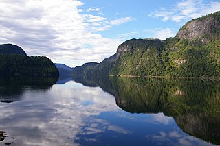
Veafjorden is a fjord in Hordaland county, Norway. The 15-kilometre (9.3 mi) long fjord flows between the mainland and the island of Osterøy in Vaksdal municipality. There is one bridge across the fjord, the Kallestadsundet Bridge near Stamneshella.