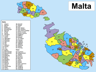
Since June 30, 1993, Malta has been subdivided into 68 localities, governed by local councils, Maltese: kunsilli lokali, meaning municipalities or borough, and the considered by the Maltese as the equivalent to a basic village or towns, where appropriate. These form the most basic type of local government and are subdivisions of the country's first-level regions.

An optical telegraph is a line of stations, typically towers, for the purpose of conveying textual information by means of visual signals. There are two main types of such systems; the semaphore telegraph which uses pivoted indicator arms and conveys information according to the direction the indicators point, and the shutter telegraph which uses panels that can be rotated to block or pass the light from the sky behind to convey information.

Għajnsielem, meaning "Spring of Sielem", is a municipality on the southeastern coast of the island of Gozo in Malta, including the entire island of Comino. It has a population of 3,200 residents, and is the first Gozitan village that greets the visitor on leaving Mġarr Harbour towards the Gozitan heartland. Its name originated from the water spring, around which in 1700, Grandmaster Perellos built an arcade containing public wash basins and fresh water spouts. Attractions include Lourdes Chapel with its sharp steeple and underlying niche of Our Lady of Lourdes, Fort Chambray and the towering of Ghajnsielem Parish Church.
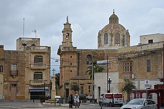
Nadur is an administrative unit of Malta, located in the eastern part of the island of Gozo. Nadur is built on a plateau and is one of the largest localities in Gozo. Known as the 'second city', it spreads along a high ridge to the east of Victoria. It had a population of 4,509 as of March 2014.

The Grandmaster's Palace, officially known as The Palace, is a palace in Valletta, Malta. It was built between the 16th and 18th centuries as the palace of the Grand Master of the Order of St. John, who ruled Malta from 1530 to 1798, and was also known as the Magisterial Palace. When the knights were expelled by Napoleonic France, it became the National Palace. During the period of British rule beginning in 1800, it was the Governor's Palace.

Malta is for non-local government purposes divided into districts as opposed to the local government localities. The three main types of such districts – statistical, electoral at national level, and policing – have no mainstream administrative effect as the local councils form the first-tier – moreover only administrative tier – divisions of the country.
This page list topics related to Malta.
The Lascaris Towers are a series of mostly small coastal watchtowers built in Malta by the Order of Saint John between 1637 and 1652. The first seven towers were built around the coast of mainland Malta in 1637 and 1638. Between 1647 and 1652, a large tower was also built on mainland Malta, and two smaller ones were built on Gozo.
In the small Mediterranean island nation of Malta, the predominant religion is Roman Catholicism.
Post codes in Malta are seven-character strings that form part of a postal address in Malta. Post codes were first introduced in 1991 by the mail operator MaltaPost. Like those in the United Kingdom and Canada, they are alphanumeric.

In Malta, most of the main roads are in the outskirts of the localities to connect one urban area with another urban area. The most important roads are those that connect the south of the island with the northern part, like Tal-Barrani Road, Aldo Moro Street in Marsa and Birkirkara Bypass.

Gozo Region is one of five regions of Malta. The region includes the islands of Gozo, Comino and several little islets such as Cominotto. The region does not border any other regions, but it is close to the Northern Region.
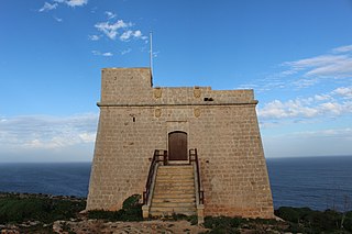
Sopu Tower, also known as Isopu Tower, San Blas Tower or Torre Nuova, is a small watchtower situated on the cliff between San Blas and Daħlet Qorrot in Nadur, Gozo, Malta.

The Giordan, Ġordan is an active lighthouse on the Maltese island of Gozo. It is located on Ġurdan hill above the village of Għasri on the northern coast of the island.

Selmun Palace, also known as Selmun Tower, is a villa on the Selmun Peninsula in Mellieħa, Malta. It was built in the 18th century by the Monte della Redenzione degli Schiavi, funded by the Monte di Pietà. The palace was located on the grounds of a hotel until it closed in 2011.

The remains of six Punic-Roman towers have been identified in Malta. They are believed to have been built while the island was part of the Punic or Roman Empires. Their architecture suggests a late Punic origin, and they remained in use throughout the Roman period, until at least the 3rd century AD. Evidence suggests that the towers were used to defend the island. The towers are clearly all built on high grounds, in specific locations, and could considerably communicate with signals from one to another. Similar towers are also found in nearby Tunisia with the same defensive system. In the context of time some locals still lived in caves with few others living in vernacular housing with similar characteristics to nearby Sicily.

The Għargħur Semaphore Tower is a semaphore tower in the town of Għargħur, Malta. It was built by the British in 1848, as one of three semaphore towers in Malta. The tower was restored in 2009, and it is now in good condition.

The Għaxaq Semaphore Tower, known locally as it-Turretta, is a semaphore tower in the town of Għaxaq, Malta. It was built by the British in 1848, as one of three semaphore towers in Malta. The tower is now leased to the Għaxaq Local Council, which plans to restore it.
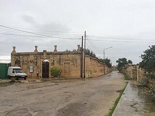
The Ġonna tal-Kmand, formerly known as Ġonna tal-Kutnent and sometimes known as Ball Gardens, are a group of gardens in various localities in Malta, which were built in the early years of the 19th century when the island was a British protectorate. The gardens were commissioned by Civil Commissioner Alexander Ball between 1802 and 1805, and were given to the Luogotenenti in charge of the towns or villages.


