
Huancavelica or Wankawilka in Quechua is a city in Peru. It is the capital of the Huancavelica region and according to the 2007 census had a population of 40,004 people. The city was established on August 5, 1572 by the Viceroy of Peru Francisco de Toledo. Indigenous peoples represent a major percentage of the population. It has an approximate altitude of 3,660 meters; the climate is cold and dry between the months of February and August with a rainy season between September and January. It is considered one of the poorest cities in Peru.

Tacora is a stratovolcano located in the Andes of the Arica y Parinacota Region of Chile. Bordering Peru, it is the northernmost volcano of Chile. It is part of the Central Volcanic Zone in Chile, one of the four volcanic belts of the Andes. The Central Volcanic Zone has several of the highest volcanoes in the world. Tacora itself is a stratovolcano with a caldera and a crater. The youngest radiometric age is 50,000 years ago and it is heavily eroded by glacial activity.

The Mantaro River is a long river running through the central region of Peru. Its Quechua name means "great river". The word "Mantaro" may be a word originally from the Ashaninka language, who live downstream along the Ene River. The Mantaro, along with the Apurimac River, are the sources of the Amazon River, depending on the criteria used for definition.

Mourasuchus is an extinct genus of giant, aberrant caiman from the Miocene of South America. Its skull has been described as duck like, being broad, flat and very elongate, closely resembling what is seen in Stomatosuchus, an unrelated crocodylian that may also have had a large gular sac similar to those of pelicans or baleen whales.

The South American land mammal ages (SALMA) establish a geologic timescale for prehistoric South American fauna beginning 64.5 Ma during the Paleocene and continuing through to the Late Pleistocene. These periods are referred to as ages, stages, or intervals and were established using geographic place names where fossil materials where obtained.
The Deseadan age is a period of geologic time within the Oligocene epoch of the Paleogene to the Early Miocene epoch of the Neogene, used more specifically within the SALMA classification of South America. It follows the Tinguirirican and precedes the Colhuehuapian age.
The Colhuehuapian age is a period of geologic time within the Early Miocene epoch of the Neogene, used more specifically within the SALMA classification in South America. It follows the Deseadan and precedes the Santacrucian age.

The Chota Formation is an Early Campanian to Late Eocene geologic formation of the Cajamarca and western Amazonas Region in northern Peru. Dinosaur remains are among the fossils that have been recovered from the formation, although none have yet been referred to a specific genus. The formation was formerly named Bagua Formation.
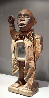
The Kotosh Religious Tradition is a term used by archaeologists to refer to the ritual buildings that were constructed in the mountain drainages of the Andes between circa 3000 and c.1800 BCE, during the Andean preceramic, or Late Archaic period of Andean history.

The archaeological site of La Galgada in Peru is an example of a ceremonial monument built within the Kotosh Religious Tradition during the preceramic, or Late Archaic period of Andean history. The site itself is located on the eastern bank of the Tablachaca River, the principal tributary of the Santa River. The site is located in the Tauca District of what is now the Pallasca Province of the Republic of Peru.
Mayombe is a geographic area on the western coast of Africa occupied by low mountains extending from the mouth of the Congo River in the south to the Kouilou-Niari River to the north. The area includes parts of the Democratic Republic of the Congo, Angola, the Republic of the Congo and Gabon. In the Democratic Republic of the Congo, Mayombe is part of the north-western province of Kongo Central on the right bank of the River Congo, and contains the cities and towns of Lukula, Seke Banza, Kangu and Tshela.
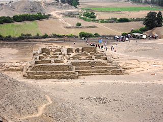
El Paraíso is the modern name of a Late Preceramic (3500-1800 BC) archaeological site located in the Chillón Valley on the central coast of Peru. The site is situated several kilometers north of Lima, the capital of Peru, in the San Martin de Porres District in the Province of Lima. El Paraíso is one of the largest settlements from this period, encompassing over 58 hectares of land.

Yanamarey or Yanaraju is a mountain in the Cordillera Blanca in the Andes of Peru, about 5,237 metres (17,182 ft) high. It is located between Recuay and Huari provinces, in Ancash. Yanamaray lies east of Pucaraju and northeast of Lake Querococha, between Matashcu in the north and Cahuish in the south.
The Pisco Formation is a geologic formation located in Peru, on the southern coastal desert of Ica and Arequipa. The approximately 640 metres (2,100 ft) thick formation was deposited in the Pisco Basin, spanning an age from the Middle Miocene up to the Late Pliocene, roughly from 15 to 3 Ma. The tuffaceous sandstones, diatomaceous siltstones, conglomerates and dolomites were deposited in a lagoonal to near-shore environment, in bays similar to other Pacific South American formations as the Bahía Inglesa and Coquimbo Formations of Chile.
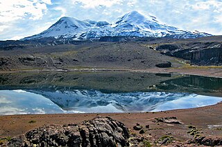
Coropuna is a dormant volcano in the southern Peruvian Andes and belonging to the Central Volcanic Zone; its summit reaches an altitude of 6,377 metres above sea level. The volcano, located 155 kilometres from Arequipa, is mostly made of lava flows on a basement formed by Miocene ignimbrites. Coropuna has been active for at least five million years, with the bulk of the current cone having formed during the Pliocene–Pleistocene.

Sabancaya is an active 5,976-metre-high (19,606 ft) stratovolcano in the Andes of southern Peru, about 70 kilometres (43 mi) northwest of Arequipa. It is considered part of the Central Volcanic Zone of the Andes, one of the three distinct volcanic belts of the Andes. The Central Volcanic Zone includes a number of volcanoes, some of which like Huaynaputina have had large eruptions and others such as Sabancaya and Ubinas have been active in historical time. Sabancaya forms a volcanic complex together with Hualca Hualca to the north and Ampato to the south and has erupted andesite and dacite. It is covered by a small ice cap which leads to a risk of lahars during eruptions.

Tutupaca is a volcano in the region of Tacna in Peru. It is part of the Peruvian segment of the Central Volcanic Zone, one of several volcanic belts in the Andes. Tutupaca consists of three overlapping volcanoes formed by lava flows and lava domes made out of andesite and dacite, which grew on top of older volcanic rocks. The highest of these is usually reported to be 5,815 metres (19,078 ft) high and was glaciated in the past.

Ticsani is a volcano in Peru. It consists of two volcanoes that form a complex: "old Ticsani", which is a compound volcano that underwent a large collapse in the past and shed 15–30 cubic kilometres (3.6–7.2 cu mi) of mass down the Rio Tambo valley; the other is a complex of three lava domes which were emplaced during the Holocene. The last eruption occurred after the 1600 eruption of neighbouring Huaynaputina.

Ubinas is a stratovolcano in the Moquegua Region of southern Peru, 60 kilometres (37 mi) east of the city of Arequipa. Part of the Central Volcanic Zone of the Andes, it is 5,672 metres (18,609 ft) above sea level. The volcano's summit is cut by a 1.4-kilometre (0.87 mi) wide and 150-metre (490 ft) deep caldera, which itself contains a smaller crater. Below the summit, Ubinas has the shape of an upwards-steepening cone with a prominent notch on the southern side. The gently sloping lower part of the volcano is also known as Ubinas I and the steeper upper part as Ubinas II; they represent different stages in the geologic history of Ubinas.
Pisco Basin is a sedimentary basin extending over 300 kilometres (190 mi) in southwestern Peru. The basin has a 2 kilometres (6,600 ft) thick sedimentary fill, which is about half the thickness of more northern foreland basins in Peru. The oldest known sediments are Eocene sandstones, while the youngest deposits date to the Pliocene. In relation to present-day topography the fill of Pisco Basin makes the upper part of the Coastal Cordillera of southern Peru, the coastal plains, the Ica-Nazca Depression and the Andean foothills.

