Related Research Articles
The Lakota are a Native American people. Also known as the Teton Sioux, they are one of the three prominent subcultures of the Sioux people, with the Eastern Dakota (Santee) and Western Dakota (Wičhíyena). Their current lands are in North and South Dakota. They speak Lakȟótiyapi—the Lakota language, the westernmost of three closely related languages that belong to the Siouan language family.

Bennett County is a county in the U.S. state of South Dakota. As of the 2020 census, the population was 3,381. Its county seat is Martin. The county lies completely within the exterior boundary of the Pine Ridge Indian Reservation. To the east is the Rosebud Indian Reservation, where dwell the Sicangu Oyate, also known the Upper Brulé Sioux Nation and the Rosebud Sioux Tribe (RST), a branch of the Lakota people.
White River is a city in and the county seat of Mellette County. South Dakota, United States. The population was 533 at the 2020 census.

Kyle is a census-designated place (CDP) in Oglala Lakota County, South Dakota, United States. Its population was 943 at the 2020 census. Located within the Pine Ridge Indian Reservation of the Oglala Lakota, it is one of two settlements which are closest to the North American continental pole of inaccessibility.
Squaw Creek may refer to:

The Belle Fourche River is a tributary of the Cheyenne River, approximately 290 miles (470 km) long, in the U.S. states of Wyoming and South Dakota. It is part of the Mississippi River watershed via the Cheyenne and Missouri rivers. In the latter part of the 19th century, the Belle Fourche River was known as the North Fork of the Cheyenne River. Belle Fourche is a name derived from French meaning "beautiful fork".
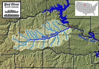
The Bad River is a tributary of the Missouri River, approximately 161 miles (259 km) long, in central South Dakota in the United States. The river is formed at Philip, South Dakota, by the confluence of its North and South forks. The North Fork Bad River rises in eastern Pennington County and flows 51 miles (82 km) east-southeast to Philip, while the South Fork Bad River rises at the confluence of Whitewater Creek and Big Buffalo Creek in Jackson County, within the Buffalo Gap National Grassland, and flows 36 miles (58 km) northeast to Philip. The main stem of the Bad River flows east-northeast from Philip, passing Midland and Capa. It joins the Missouri at Fort Pierre. The Bad drainage basin is about 3,000 square miles (7,800 km2) and is located south of the Cheyenne River in the Pierre Hills and Southern Plateaus.

Wounded Knee Creek is a tributary of the White River, approximately 100 miles (160 km) long, in Oglala Lakota County, South Dakota in the United States. Its Lakota name is Čhaŋkpé Ópi Wakpála.

West River is the portion of the state of South Dakota located west of the Missouri River; it contains more than one-half of the land area and between one-quarter and one-third of the population of the state.
Porcupine Butte is a mountain summit located on the Pine Ridge Indian Reservation in Oglala Lakota County, South Dakota. Porcupine Butte is 3,665 feet above sea level. The nearest municipality to Porcupine Butte is Wounded Knee, 2.3 miles away. KILI Radio, 90.1 FM maintains their broadcast facilities at Porcupine Butte, with the transmit tower located on the butte. There is also a fire watchtower located at the top of the butte. BIA Highway 27, also known as Big Foot Trail passes by the butte.
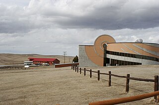
Oglala Lakota College (OLC) is a public tribal land-grant community college in Kyle, South Dakota. It enrolls 1,456 students enrolled part- and full-time. OLC serves the Pine Ridge Indian Reservation, which has a population of about 26,000 and covers 3,468 square miles in southwestern South Dakota.
Ponca Creek is a stream that flows from southern South Dakota and into northern Nebraska. It is 139 miles (224 km) long. Its source is about 4 miles (6.4 km) west of U.S. 183, near Colome. It flows into the Missouri River 6 miles (9.7 km) northwest of Niobrara. Ponca Creek starts out going east, then takes a southeast direction, which continues until around Bristow, Nebraska, where it turns east again until it flows into the Missouri River. The entire Ponca Creek watershed drains 520,000 acres (2,100 km2). The watershed stretches from central Tripp County to central Gregory County.
Squaw Humper Dam is a dam on Tahc'a Okute Wakpa in Oglala Lakota County, South Dakota, in the United States. It is located within Pine Ridge Indian Reservation, the lands of the Oglala Lakota Nation.
Denby is an unincorporated community in Oglala Lakota County, in the U.S. state of South Dakota.
Potato Creek is a stream in the U.S. state of South Dakota. It is a tributary of the White River.
Rockyford is an unincorporated community in Oglala Lakota County, in the U.S. state of South Dakota. It is on the Pine Ridge Indian Reservation.
American Horse Creek is a stream in the U.S. state of South Dakota.
Battle Creek is a stream in the U.S. state of South Dakota. It is a tributary of the Cheyenne River, traversing Oglala Lakota and Pennington counties and the town of Keystone.
Grass Creek is a stream in the U.S. state of South Dakota.
No Flesh Creek is a stream in the U.S. state of South Dakota.
References
- 1 2 3 U.S. Geological Survey Geographic Names Information System: Tahc'a Okute Wakpa
- ↑ William Bright (2004). Native American Placenames of the United States. University of Oklahoma Press. p. 460. ISBN 978-0-8061-3598-4.
- ↑ Federal Writers' Project (1940). South Dakota place-names, v.3. University of South Dakota. p. 62.
43°36′50″N102°57′27″W / 43.6138°N 102.9574°W
| | This article related to a river in South Dakota is a stub. You can help Wikipedia by expanding it. |