Related Research Articles
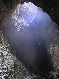
Harwoods Hole is a cave system located in the northwest of the South Island of New Zealand. At 183 metres (600 ft), it is New Zealand's deepest vertical shaft. It was first explored in 1958, long after it was discovered.
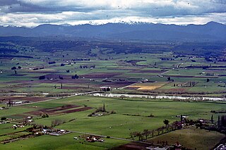
Tapawera is a small town in New Zealand's South Island. It is located thirty kilometres southwest of Nelson by the banks of the Motueka River. The population including the surrounding area was 396 in the 2013 census, a decrease of 9 from 2006. The town is a gateway to the Kahurangi National Park.

Takaka Hill is a range of hills in the northwest of the South Island of New Zealand. Made of marble that has weathered into many strange forms and with numerous sink holes, it is typical karst country. The marble is Ordovician in age and from the Takaka Terrane.

Tata / Near Beach is a beach and small coastal settlement of predominantly holiday houses in the South Island, New Zealand. Found in the Golden Bay region, it is approximately 20 kilometres (12 mi) north-east of Takaka.
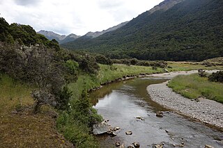
The Anatoki River is a river of New Zealand. It is located in the Tasman Region, and is a tributary of the Takaka River and is one of the country's steepest rivers. The river's name means cave of stone adzes.
The Cobb River is a river in the Tasman Region of New Zealand. It flows southeast from Lake Cobb on the northern slopes of Mount Cobb, in Kahurangi National Park, in the northwestern South Island. The river's waters are captured behind a dam to become the Cobb Reservoir; the outflow continues to join with the Takaka River. The river is named for J.W. Cobb, a local mill owner, who discovered it.
The Devil River is a river of New Zealand's Tasman Region. It starts between the Devil Range and the Anatoki Range and flows generally east through the Kahurangi National Park, reaching the Takaka River 13 kilometres (8 mi) south of the town of Takaka.
The Little Devil River is a river of the Tasman Region of New Zealand's South Island. It flows southeast to reach the Devil River 15 kilometres southwest of Takaka.
The Little Onahau River is a river of the northwest of New Zealand's South Island. It flows north from the Haupiri Range west of Takaka, joining with the Onahau River shortly before the latter's outfall into Golden Bay.
The Little Waingaro River is a river of the Tasman Region of New Zealand. It is a tributary of the Waingaro River, which it meets 10 kilometres south of Takaka.
The Motupipi River is a short river of the Tasman Region of the South Island of New Zealand. It flows north to reach Golden Bay to the east of Takaka.

The Onahau River is a river of the Tasman Region of New Zealand's South Island. It has its sources close to the northernmost point of Kahurangi National Park, from where it flows northeast to reach Golden Bay to the northwest of Takaka. The smaller Little Onahau River follows a roughly parallel course to the southwest of the Onahau River.
The Onekaka River is a river of the Tasman Region of New Zealand's South Island. It flows south from its sources in the northeast of Kahurangi National Park, reaching Golden Bay 13 kilometres northwest of Takaka.
The Otere River is a short river of the Tasman Region of New Zealand's South Island. It flows north to reach Golden Bay approximately halfway between Takaka and Collingwood.
The Pariwhakaoho River is a river of the Tasman Region of New Zealand's South Island. It flows northeast from sources within Kahurangi National Park to reach Golden Bay 10 kilometres northwest of Takaka.
The Puremahaia River is a river of the Tasman Region of New Zealand's South Island. It flows northeast, reaching Golden Bay five kilometres northwest of Takaka.

The Waikoropupu River is a river of the Tasman Region of New Zealand's South Island.It originates in the Kahurangi National Park and flows generally northeast to reach the Takaka River close to the town of Takaka. On its way it passes close to the Te Waikoropupū Springs, which drain into the river and add significantly to its water volume.
The Stanley River is a river of the Tasman Region of New Zealand's South Island. It flows southeast from its sources in the Douglas and Anatoki Ranges, reaching the Waingaro River 12 kilometres west of Upper Takaka.
The Snow River is a river in the Tasman Region of the South island of New Zealand. It rises at the western end of the Haupiri Range and flows northward before rounding the tip of Kill Devil Spur to join the Slate River. The Slate River is a tributary of the Aorere River, the major river of the northwestern Tasman region.
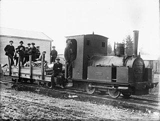
The Takaka Tramway was a narrow gauge light railway which operated in the Takaka Valley, Golden Bay, New Zealand from 1882 to 1905, linking farms and sawmills of the Takaka Valley with the tidal port of Waitapu at the mouth of the Takaka River.
References
- ↑ "Fast-spreading didymo cloaking parts of river", Nelson Mail.
Coordinates: 40°49′S172°48′E / 40.817°S 172.800°E
| This article about a river in the Tasman District is a stub. You can help Wikipedia by expanding it. |