Related Research Articles

According to the International Civil Aviation Organization (ICAO), a runway is a "defined rectangular area on a land aerodrome prepared for the landing and takeoff of aircraft". Runways may be a human-made surface or a natural surface. Runways, taxiways and ramps, are sometimes referred to as "tarmac", though very few runways are built using tarmac. Takeoff and landing areas defined on the surface of water for seaplanes are generally referred to as waterways. Runway lengths are now commonly given in meters worldwide, except in North America where feet are commonly used.

METAR is a format for reporting weather information. A METAR weather report is predominantly used by aircraft pilots, and by meteorologists, who use aggregated METAR information to assist in weather forecasting. Today, according to the advancement of technology in civil aviation, the METAR is sent as IWXXM model.

Southwest Airlines Flight 1248 was a scheduled passenger flight from Baltimore, Maryland, to Chicago, Illinois, continuing on to Salt Lake City, Utah, and then to Las Vegas, Nevada. On December 8, 2005, the airplane slid off a runway at Midway Airport in Chicago while landing in a snowstorm and crashed into automobile traffic, killing a six-year-old boy.
Braking action in aviation is a description of how easily an aircraft can stop after landing on a runway. Either pilots or airport management can report the braking action according to the U.S. Federal Aviation Administration.

Cuyahoga County Airport, also known as Robert D. Shea Field, is a public use airport in northeastern Cuyahoga County, Ohio, United States. Owned and operated by Cuyahoga County since 1946, it also serves Lake County and Geauga County. The airport is located 10 nautical miles east of downtown Cleveland and sits on the border of three cities: Highland Heights, Richmond Heights and Willoughby Hills. It is included in the National Plan of Integrated Airport Systems for 2011–2015, which categorized it as a general aviation reliever airport for Cleveland Hopkins International Airport.
In aviation, a balanced field takeoff is a condition where the takeoff distance required (TODR) with one engine inoperative and the accelerate-stop distance are equal for the aircraft weight, engine thrust, aircraft configuration and runway condition. For a given aircraft weight, engine thrust, aircraft configuration, and runway condition, the shortest runway length that complies with safety regulations is the balanced field length.

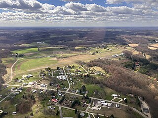
Jackson County Airport, also known as Reynolds Field, is a county-owned, public-use airport located two nautical miles (3.7 km) west of the central business district of Jackson, in Jackson County, Michigan, United States. It is a class D airport with operating control tower. It is included in the Federal Aviation Administration (FAA) National Plan of Integrated Airport Systems for 2017–2021, in which it is categorized as a regional general aviation facility.
Frankfort Dow Memorial Field is a public use airport located two nautical miles (3.7 km) southeast of the central business district of Frankfort, a city in Benzie County, Michigan, United States. It is owned by the Frankfort City-County Airport Authority. It is included in the Federal Aviation Administration (FAA) National Plan of Integrated Airport Systems for 2017–2021, in which it is categorized as a general aviation facility.
Harbor Springs Municipal Airport, also known as Harbor Springs Airport, is a public airport located three miles (5 km) east of the central business district of Harbor Springs, a city in Emmet County, Michigan, United States. It is included in the Federal Aviation Administration (FAA) National Plan of Integrated Airport Systems for 2017–2021, in which it is categorized as a local general aviation facility.
Portage County Airport, also known as Portage County Regional Airport, is a public use airport in Portage County, Ohio, United States. It is owned by the Portage County Board of Commissioners and located three nautical miles (6 km) north of Ravenna, in Shalersville Township. This airport is included in the National Plan of Integrated Airport Systems for 2011–2015, which categorized it as a general aviation facility.
A runway excursion is a runway safety incident in which an aircraft makes an inappropriate exit from the runway.

A runway safety area (RSA) or runway end safety area is defined as "the surface surrounding the runway prepared or suitable for reducing the risk of damage to airplanes in the event of an undershoot, overshoot, or excursion from the runway."

Waukegan National Airport is a public airport in Waukegan, in Lake County, Illinois. The airport is 40 miles (64 km) north of Chicago. It was originally Waukegan Memorial Airport. It has been operated by the Waukegan Port District since 1956. In January 2014 under a FAA reclassification of many small airports, the airport was renamed Waukegan National Airport

In aviation, V-speeds are standard terms used to define airspeeds important or useful to the operation of all aircraft. These speeds are derived from data obtained by aircraft designers and manufacturers during flight testing for aircraft type-certification. Using them is considered a best practice to maximize aviation safety, aircraft performance, or both.
Carroll County–Tolson Airport is a county–owned, public-use airport located one nautical mile (1.85 km) southeast of the central business district of Carrollton, a village in Carroll County, Ohio, United States. It is owned by the Carroll County Airport Authority. According to the FAA's National Plan of Integrated Airport Systems for 2009–2013, it is categorized as a general aviation airport.
Cambridge Municipal Airport is three miles south of Cambridge, in Guernsey County, Ohio. The FAA's National Plan of Integrated Airport Systems for 2011–2015 categorized it as a general aviation facility.
Runway safety is concerned with reducing harm that could occur on an aircraft runway. Safety means avoiding incorrect presence (incursion) of aircraft, inappropriate exits (excursion) and use of the wrong runway due to confusion. The runway condition is a runway's current status due to meteorological conditions and air safety.
Hastings Airport is a public use airport located three nautical miles (6 km) west of the central business district of Hastings, a city in Barry County, Michigan, United States. It is owned by the city and county and is also known as Hastings City/Barry County Airport.
Parker County Airport is a privately owned public airport in Hudson Oaks, Parker County, Texas, United States. The airport serves the city of Weatherford, and is located approximately 5 nautical miles (9.3 km) east of the central business district.

Ryan International Airlines Flight 590 was a cargo flight carrying mail for the United States Postal Service from Greater Buffalo International Airport (BUF) in Buffalo, New York, to Indianapolis International Airport (IND) in Indiana, with a stopover at Cleveland Hopkins International Airport (CLE) in Cleveland, Ohio. On February 17, 1991, the McDonnell Douglas DC-9-15RC operating the flight crashed on takeoff from Cleveland during icing conditions. Both pilots, the aircraft's only occupants, were killed. The National Transportation Safety Board (NTSB) determined that the causes of the crash were the flight crew failing to deice their aircraft, and the inexperience of the Federal Aviation Administration (FAA), McDonnell Douglas, and Ryan International Airlines with icing condition on DC-9-10 aircraft.
References
- 1 2 "Takeoff and Landing Performance Assessment (TALPA)". NBAA - National Business Aviation Association. Retrieved 28 September 2023.
- ↑ "8900.1 CHG 470 Landing Distance Assessment" (PDF). FAA. Retrieved 27 September 2023.
- ↑ "SAFO 16009: Runway Assessment and Condition Reporting" (PDF). 15 August 2016. Retrieved 27 September 2023.