
The 80s was a decade that ran from January 1, AD 80, to December 31, AD 89.

Limes is a term used primarily for the Germanic border defence or delimiting system of Ancient Rome marking the borders of the Roman Empire. The term has been extended in modern times to refer to the frontier defences in other parts of the empire, such as in the east and in Africa.

Legio XXX Ulpia Victrix was a legion of the Imperial Roman army. Their emblems were the gods Neptune and Jupiter and the Capricorn. Ulpia is Trajan's own gens (Ulpia), while the cognomen "Victrix" means "victorious," and it was awarded after their valiant behaviour in the Dacian wars. The legion was active until the disbandment of the Rhine frontier in the beginning of the 5th century.

Germania Superior was an imperial province of the Roman Empire. It comprised an area of today's western Switzerland, the French Jura and Alsace regions, and southwestern Germany. Important cities were Besançon (Vesontio), Strasbourg (Argentoratum), Wiesbaden, and Germania Superior's capital, Mainz (Mogontiacum). It comprised the Middle Rhine, bordering on the Limes Germanicus, and on the Alpine province of Raetia to the south-east. Although it had been occupied militarily since the reign of Augustus, Germania Superior was not made into an official province until c. 85 AD.

Nikopol is a town in northern Bulgaria, the administrative center of Nikopol Municipality, part of Pleven Province, on the right bank of the Danube river, 4 kilometres downstream from the Danube’s confluence with the Osam river. It spreads at the foot of steep chalk cliffs along the Danube and up a narrow valley.
The Limes Germanicus, or 'Germanic Limes', is the name given in modern times to a line of frontier fortifications that bounded the ancient Roman provinces of Germania Inferior, Germania Superior and Raetia, dividing the Roman Empire and the unsubdued Germanic tribes from the years 83 to about 260 AD. The frontier used either a natural boundary such as a river or typically an earth bank and ditch with a wooden palisade and watchtowers at intervals, and a system of linked forts was built behind them.

Donji Milanovac is a town in eastern Serbia. It is situated in the Majdanpek municipality, in the Bor District. It is located on the right bank of Lake Đerdap on the Danube. The population of the town is 2,410 people. Its name means "Lower Milanovac".
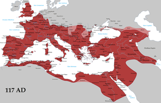
The borders of the Roman Empire, which fluctuated throughout the empire's history, were realised as a combination of military roads and linked forts, natural frontiers and man-made fortifications which separated the lands of the empire from the countries beyond.

Roman military borders and fortifications were part of a grand strategy of territorial defense in the Roman Empire, although this is a matter of debate. By the early 2nd century, the Roman Empire had reached the peak of its territorial expansion and rather than constantly expanding their borders as earlier in the Empire and Republic, the Romans solidified their position by fortifying their strategic position with a series of fortifications and established lines of defense. Historian Adrian Goldsworthy argues that the Romans had reached the natural limits which their military traditions afforded them conquest over and that beyond the borders of the early-to-mid Empire lay peoples whose military traditions made them militarily unconquerable, despite many Roman battle victories. In particular, Goldsworthy argues that the cavalry-based warfare of the Parthians, Sarmatians and Persians presented a major challenge to the expansion of Rome's infantry-based armies.

The Moesian Limes is the modern term given to a linked series of Roman forts on the northern frontier of the Roman province of Moesia along the Danube between the Black Sea shore and Pannonia and dating from the 1st century AD. It was the eastern section of the so-called Danubian Limes and protected the Roman provinces of Upper and Lower Moesia south of the river. The eastern section is often called the limes Scythiae minoris as it was located in the late Roman province of Scythia Minor.

The Devil's Dykes, also known as the Csörsz árka or the Limes Sarmatiae, are several lines of Roman fortifications built mostly during the reign of Constantine the Great (306–337), stretching between today's Hungary, Romania and Serbia.

Mosna is a village in Serbia. It is situated in the Majdanpek municipality, in the Bor District. The nearest town is Donji Milanovac. The village has a Serb ethnic majority and its population numbering 787 people.
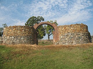
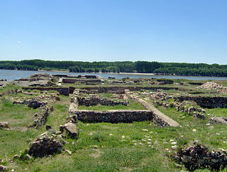
Diana Fort is a Roman fort located near the hamlet of Karataš, 8 km northwest of Kladovo, in eastern Serbia in the Karataš archaeological site. It is located on cliffs of the Đerdap, above the Danube, on a strategic location overlooking the Danube frontier. It has been extensively excavated, is one of the best explored forts of the Moesian Limes, and can be visited today.

Comagena was a fortified Roman camp on the Danube, on the site of the modern town of Tulln on the Danube in Lower Austria, Austria. Built as a defensive work along the Norican frontier, it originally housed an ala of up to 500 cavalry troops. From its exposed situation, it was able to guard a militarily significant ford over the Danube and control the valley lowlands for a good distance upstream and down.
Capidava was an important Geto-Dacian center on the right bank of the Danube. After the Roman conquest, it became a civil and military centre, as part of the province of Moesia Inferior and was part of the defensive frontier system of the Limes Moesiae along the Danube.

Slovakia was partly occupied by Roman legions for a short period of time. Marcomannia was a proposed province of the Roman Empire that Emperor Marcus Aurelius planned to establish in this territory. It was inhabited by the Germanic tribes of Marcomanni and Quadi, and lay in the western parts of the modern states and Slovakia and the Czech Republic (Moravia). Part of the area was occupied by the Romans under Marcus Aurelius between 174 AD and 180 AD. His successors abandoned the project, but the people of the area became steadily Romanized during the next two centuries. The Roman influence was disrupted with the invasions of Attila starting around 434 AD and as Slavic people later began to move into the area.
The Danubian Limes, or Danube Limes, refers to the Roman military frontier or limes which lies along the River Danube in the present-day German state of Bavaria, in Austria, Slovakia, Hungary, Croatia, Serbia, Bulgaria and Romania.

The Dacian Limes is the generic modern term given to a collection of ramparts and linked series of Roman forts on the frontiers of the Roman province of Dacia dating from the 1st century AD. They ran for about 1,000 km and included the:

The Danube–Iller–Rhine Limes or DIRL was a large-scale defensive system of the Roman Empire that was built after the project for the Upper Germanic-Rhaetian Limes in the late 3rd century AD. In a narrower sense the term refers only to the fortifications between Lake Constance and the River Danube (Danubius); in a broader sense it also includes the other Late Roman fortifications along the river Rhine (Rhenus) on the High Rhine and on the Upper Rhine as well as the Upper Danube.
Braničevo Fortress is an archaeological site of medieval fortress whose remains are situated in the village of Kostolac, in Serbia, about 130km east of Belgrade and 24 km from northeast of Požarevac. It consists of two Medieval fortified structures located in Mali Grad and Veliki Grad, on the right bank of the Danube and above Dunavac and the Mlava River.


