Bø may refer to the following:

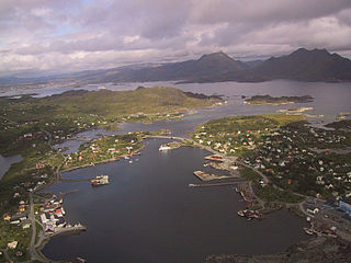
Leknes (help·info) is a town in Nordland county, Norway. The town is also the administrative centre of the municipality of Vestvågøy. Leknes was designated a "town" in 2002. The 2.52-square-kilometre (620-acre) town has a population (2018) of 3,556 which gives the town a population density of 1,411 inhabitants per square kilometre (3,650/sq mi).

Stamsund is a fishing village in Vestvågøy Municipality in Nordland county, Norway. It is located on the southern side of the island of Vestvågøy in the Lofoten archipelago, along the Vestfjorden. The village is located about 12 kilometres (7.5 mi) east of the town of Leknes. The 1.06-square-kilometre (260-acre) village has a population (2018) of 1,092 which gives the village a population density of 1,030 inhabitants per square kilometre (2,700/sq mi). Historically, the village was the administrative centre of Hol Municipality from 1919 until 1963.

Andfiskvatnet is a lake in the municipality of Rana in Nordland county, Norway. The 2.7-square-kilometre (1.0 sq mi) lake lies about 3 kilometres (1.9 mi) southeast of the village of Hauknes and about 6 kilometres (3.7 mi) south of the town of Mo i Rana. The lake flows out into the river Andfiskåga which flows into the Ranfjorden.

Baugevatnet is a lake that lies in Tysfjord Municipality in Nordland county, Norway. The 4.99-square-kilometre (1.93 sq mi) lake is located about 25 kilometres (16 mi) east of the village of Kjøpsvik and just 1.5 kilometres (0.93 mi) northwest of the border with Sweden. The lake Båvrojávrre lies about 3 kilometres (1.9 mi) to the southwest and the lake Langvatnet lies about the same distance to the north.

Ramsgjelvatnet is a lake that lies in the municipality of Beiarn in Nordland county, Norway. The lake is located about 5 kilometres (3.1 mi) northeast of the village of Høyforsmoen and about 15 kilometres (9.3 mi) southeast of the village of Moldjord.
Bøstad is a village in Vestvågøy Municipality in Nordland county, Norway. It is located along the European route E10 highway just next to the hamlet of Borg in the central part of the island of Vestvågøya in the Lofoten archipelago. Borge Church is located in Borg, very close to the village of Bøstad. Historically, this village was the administrative centre of the old Borge Municipality which existed from 1838 until 1963.

Valberg is a former municipality in Nordland county, Norway. The 57-square-kilometre (22 sq mi) municipality existed from 1927 until 1963. The municipality covered the southeastern coast of the island of Vestvågøya in what is now Vestvågøy Municipality. The administrative centre was the village of Valberg where Valberg Church is located.

Borge is a parish and former municipality in Nordland county, Norway. The 200-square-kilometre (77 sq mi) municipality existed from 1838 until 1963. It was located on the northern part of the island of Vestvågøya in what is now Vestvågøy Municipality. The administrative centre of the municipality was the village of Bøstad where Borge Church is located.

Buksnes is a former municipality in Nordland county, Norway. The 102-square-kilometre (39 sq mi) municipality existed from 1838 until its dissolution in 1963. It comprised the western part of the island of Vestvågøya in what is now Vestvågøy Municipality. The administrative centre was located in the village of Gravdal where the main church for the municipality, Buksnes Church, is located.

Hol is a former municipality in Nordland county, Norway. The 67-square-kilometre (26 sq mi) municipality existed from 1919 until its dissolution in 1963. Hol was located on the island of Vestvågøya in the southeastern part of what is now Vestvågøy Municipality. The administrative centre was located in Stamsund. The main church for Hol was Hol Church which is located just outside of the village of Fygle.

Gravdal is a village in Vestvågøy Municipality in Nordland county, Norway. It is located on the island of Vestvågøya in the central part of the Lofoten archipelago, north of the Arctic Circle. The village is situated along the shore of the Buksnesfjorden, about 3 kilometres (1.9 mi) southwest of the town of Leknes. The village also lies approximately 72 kilometres (45 mi) west of the town of Svolvær and 63 kilometres (39 mi) east of the village of Å in Moskenes. Historically, the village was the administrative centre of the old Buksnes municipality which existed from 1838 until 1963.
Ramberg may refer to places in:

Ballstad is a village in Vestvågøy Municipality in Nordland county, Norway. It is located on a small island off the southwestern tip of the island of Vestvågøya in the Lofoten archipelago. It is one of the largest fishing villages in Lofoten.
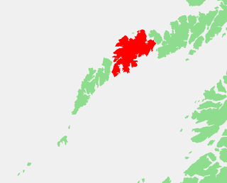
Vestvågøya or Vest-Vågøy is an island in the Lofoten archipelago in Nordland county, Norway. The island is located within Vestvågøy Municipality. The island lies between the islands of Austvågøya and Gimsøya to the northeast and Flakstadøya to the southwest. There are also several small islands and skerries surrounding the island. Vestvågøya makes up over 97% of the municipal area and about 99% of the inhabitants of the municipality live on the island. The European route E10 highway crosses the island connecting to Flakstadøya by the Nappstraum Tunnel and to Gimsøya by the Sundklakkstraumen Bridge.

Skottinden is a mountain in the Lofoten archipelago, in Nordland county, Norway. It is located on the southwestern part of the island of Vestvågøya in Vestvågøy Municipality. The 671-metre (2,201 ft) tall mountain is situated about 2 kilometres (1.2 mi) northwest of the village of Ballstad and about 1 kilometre (0.62 mi) east of the Nappstraumen strait separating the islands of Vestvågøya and Flakstadøya.

Knutstad Chapel is a chapel of the Church of Norway in Vestvågøy Municipality in Nordland county, Norway. It is located in the village of Knutstad on the island of Vestvågøya. It is an annex chapel in the Borge parish which is part of the Lofoten prosti (deanery) in the Diocese of Sør-Hålogaland. The white, wooden chapel was built in a long church style in 1915. The chapel seats about 120 people.
Steine is a fishing village in the municipality of Vestvågøy in Nordland county, Norway. The village lies on the south side of the island of Vestvågøya, about 3 kilometres (1.9 mi) west of the village of Stamsund.