The two main products that are produced in this municipality are peanuts and bricks. Tarimoro's peanuts are unlike those found anywhere else. They are very distinct, with a thin shell and a sweeter taste. The lands in and around Tarimoro are very fertile and are irrigated by a canal that runs off a local dam called "La Presa del Cubo".
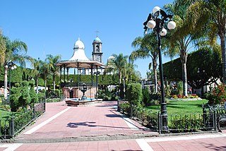
Tarimoro's main areas within Tarimoro City itself are known as "El Barrio", "El Centro", and "La Loma". Other communities such as "El Aguacate" are within walking distance of Tarimoro.
Tarimoro's local festivities are in the month of September. The festivities begin on the 20th and end with a grand finale celebration on the 29th. These traditional, local festivities reflect and honor the patron saint of Tarimoro, which is San Miguel. Giant floats are created and are adorned beautifully with many decorations of bright lively colors and full of life size religious characters. The floats are driven through downtown Tarimoro followed by local bands playing their own unique tunes that entertain hundreds of citizens and tourists alike.
The majority of Tarimoro's population have families living in the United States. Particularly concentrated in Dallas, Chicago, San Francisco, San Antonio, and many others scattered over the country. The amount of funds that comes into Tarimoro every year from relatives in the United States has a great impact on its citizens' lives, and is accounted as the main source of income for many families.
Tarimoro has mountains to the east, along with a national preserve to the southeast. The climate there is subtropical with rains in September and cold weather from November to January.
Celaya is a city and its surrounding municipality in the state of Guanajuato, Mexico, located in the southeast quadrant of the state. It is the third most populous city in the state, with a 2005 census population of 310,413. The municipality for which the city serves as municipal seat, had a population of 415,869. The city is located in the geographic center of the municipality, which has an areal extent of 553.1 km2 (213.6 sq mi) and includes many smaller outlying communities, the largest of which are San Miguel Octopan, Rincón de Tamayo and San Juan de la Vega.
Coatepec Harinas is one of 125 municipalities in the State of Mexico, Mexico. The municipal seat is the town of Coatepec Harinas. The original name is "Coauhtepetl" which means 'serpent hill' in Náhuatl. Around 1825 because of a boom in flour production, the name "Harinas" was added.
Zitácuaro, officially known as Heroica Zitácuaro, is a city in the Mexican state of Michoacán. The city is the administrative centre for the surrounding municipality of the same name, which lies at the extreme eastern side of Michoacán and borders on the adjacent state of México. The city reported a population of 185,534 in the 2010 census. The municipality has an area of 498 km2. The name Zitácuaro comes from Mazahua Tsitákuarhu.
Acámbaro is a city and municipality in the southeastern corner of the Mexican state of Guanajuato, on the banks of the Lerma River, and the oldest of the 46 municipalities of Guanajuato. Acámbaro was originally a Purépecha settlement which was invaded by the Spanish, and their Otomi allies, in 1526. Acámbaro is noted as a major railway junction, a local transport hub, and the origin of the nationally famous Acámbaro bread. The 2005 census population of the municipality was 101,762, and that of the city proper 55,082. The municipality covers an area of 877.8 km2 and includes many small outlying communities, the largest of which are Iramuco and Parácuaro.
Motril is a town and municipality of Spain belonging to the province of Granada, in the autonomous community of Andalusia.
Cuautla, Jalisco, is a small town and municipality located in the hills of western Mexico. It is situated at an elevation of 5,639 ft. between Guadalajara and Puerto Vallarta. The municipality has fewer than 3,000 permanent residents.
Tequisquiapan is a town and municipality located in the southeast of the state of Querétaro in central Mexico. The center of the town has cobblestone streets, traditional rustic houses with wrought iron fixtures, balconies, and wooden windowsills, which is the legacy of its 300-year heritage as a colonial town populated mostly by indigenous people. This, the climate, and the local natural water springs have made the town a popular weekend getaway for cities such as Querétaro and Mexico City, which has led to the construction of weekend homes in the town.
Diriamba is a city and a municipality in the Carazo department of Nicaragua, with a population of 65,243. It is located 41 km south of Managua, the capital of Nicaragua.
Rioverde is a city and its surrounding municipality located in the south-central part of the state of San Luis Potosí, Mexico. It is the fifth-most populated city in the state, behind San Luis Potosí, Soledad de Graciano Sánchez, Ciudad Valles, and Matehuala. The city had a 2005 census population of 49,183, while the municipality, of which it serves as municipal seat, had a population of 85,945 and an area extent of 3,064 km2. The population of its metropolitan area, which includes the largest municipality of Ciudad Fernández, was 126,997.
Panales Jamaica is a small town in the Tarimoro Municipality of Guanajuato, Mexico. It lies between the cities of Celaya and Salvatierra. It is in El Bajío, a valley region of central Mexico. It has mainly an agricultural economy, but it is beginning to industrialize thanks to the highway that passes through the very middle of Cañones. It has a population of about 3,000 people. It was founded in the late 16th century. It has begun to develop intensely over the past decade making it the second largest town in its area. Many of the people of this town have family in Dallas, Los Angeles, Detroit, Illinois, and scattered all over the U.S.A. The lands in and around Tarimoro are very fertile and are irrigated by a canal that runs from a local dam called "La Presa del Cubo".
Alcantarilla is a town and municipality in southeastern Spain, in the Autonomous Community of the Region of Murcia. The town is only 7 km away from the capital of the region, the city of Murcia, and one of its peculiarities is that it is completely surrounded by "pedanías" of the municipality of Murcia like Sangonera La Seca, San Ginés, Nonduermas, Puebla de Soto, La Ñora, Javalí Viejo and Javalí Nuevo.
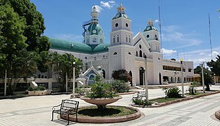
La Moncada is a small town in the Tarimoro Municipality of Guanajuato, Mexico. The town has a population of 5,100 and sits on the road from Tarimoro City to Federal Highway 51, it was founded in 1877 as La Moncada San José.
Los Ramones is the name of a municipality and its corresponding seat of government and main population center in Mexican state of Nuevo Leon.
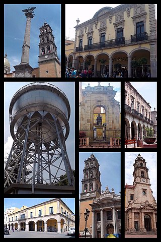
Tarimoro is the municipal seat of the municipality of Tarimoro in the Mexican state of Guanajuato.
San Juan de la Maguana is a city and municipality in the western region of the Dominican Republic and capital of the San Juan province. It was one of the first cities established on the island; founded in 1503, and was given the name of San Juan de la Maguana by San Juan Bautista and the Taino name of the valley: Maguana. The term Maguana means "the first stone, the unique stone".
Uriangato is a city and one of 46 municipalities of Guanajuato, located just north of the border between the states of Guanajuato and Michoacán in west central Mexico. Uriangato city is geographically united with Moroleon city and Yuriria city, these three cities form a metropolitan area. Since October 2010, this metropolitan area is the 75th biggest city of Mexico and the 5th biggest in Guanajuato. It is smallest of the 56 metropolitan areas in Mexico.
Jerécuaro is a Mexican city located in the lowlands of the state of Guanajuato. The municipality has an area of 828.3 square kilometres and is bordered to the north by Apaseo el Alto, to the east by Coroneo and the state of Querétaro, to the south by Tarandacuao, to the southwest with Acámbaro, and to the northwest with Tarimoro. The municipality had 55,311 inhabitants according to the 2005 census. The municipal president of Jerécuaro and its many smaller outlying communities is C.Jaime García Cardona.
Santiago Papasquiaro is a municipality in the Mexican state of Durango. The municipal seat lies at Santiago Papasquiaro. The municipality covers an area of 7,238.4 km2. Santiago Papasquiaro municipality is at an average height of 1,730 m (5,675 ft) over the sea level. The municipality lies east of Sierra Madre Occidental Mountain Range. It neighbors with the municipalities of Canelas and Tepehuanes to the north, San Dimas and Otáez to the south, Nuevo Ideal to the east, Tamazula to the west and El Oro to the northeast.
Tecolotlán is a town and municipality, in Jalisco in central-western Mexico. The municipality covers an area of 765.1 km2.
Tezonapa is a municipality located in the high mountain region in the Mexican state of Veracruz, about 219 km from the state capital Xalapa. It covers an area of 351 square kilometres (136 sq mi). The law number 93 of December 22, 1960 San Agustín created Tezonapa's municipality with the congregations of the Josefinas, Prison, Tezonapa, Palmarito, etc.
This page is based on this Wikipedia article Text is available under the CC BY-SA 4.0 license; additional terms may apply. Images, videos and audio are available under their respective licenses.