Tarndanyangga

Last updated

Adelaide CBD (looking south across the Torrens River) Aerial - Adelaide CBD 1.jpg
Adelaide CBD (looking south across the Torrens River)

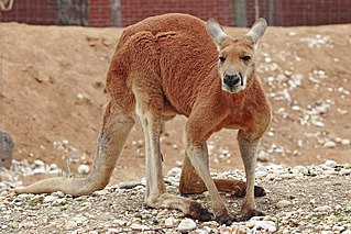
Tarndanyangga ( 34°55′50″S138°36′15″E / 34.93056°S 138.60417°E / -34.93056; 138.60417 ) (Kaurna pronunciation:  [ˈd̪̥aɳɖaɲaŋɡa] [1] ) is the Kaurna word for red kangaroo dreaming or red kangaroo rock, used by the Kaurna people, who inhabited the whole Adelaide Plains area before European settlement, to refer to the Adelaide city and parklands area. [2]

Kaurna is a Pama-Nyungan language historically spoken by the Kaurna peoples of the Adelaide Plains of South Australia. The people of the Adelaide plains are known as the Kaurna people in contemporary times, but the Kaurna nation is made up of various tribal clan groups, each with their own parnkarra district of land, each having had their own dialectal form of language. These dialects were historically spoken in the area of the Adelaide Plains bounded by Crystal Brook and Clare in the north, Cape Jervis in the south, and just over the Mount Lofty ranges. It ceased to be spoken on an everyday basis in the 19th century, but, in a process that began in the 1990s, is being reclaimed and re-introduced.

Adelaide Plains South Australia

The Adelaide Plains is a plain in South Australia lying between the coast on the west and the Mount Lofty Ranges on the east. The southernmost tip of the plain is in the southern seaside suburbs of Adelaide around Brighton at the foot of the O'Halloran Hill escarpment with the south Hummocks Range and Wakefield River roughly approximating the northern boundary.

Adelaide Park Lands

The Adelaide Park Lands are the figure-eight of land spanning both banks of the River Torrens between Hackney and Thebarton and separating the City of Adelaide from the surrounding suburbia of greater Metropolitan Adelaide, the capital city of South Australia. They were laid out by Colonel William Light in his design for the city, and originally consisted of 2,300 acres (930 ha) "exclusive of 32 acres (13 ha) for a public cemetery". One copy of Light's plan shows areas for a cemetery and a Post and Telegraph Store on West Tce, a small Government Domain and Barracks on the central part of North Tce, a hospital on East Tce, a Botanical Garden on the River Torrens west of North Adelaide, and a school and a storehouse southwest of North Adelaide.

Contents

It has also been used since 2001 as half of the official name of the central city square of the city of Adelaide named Victoria Square in 1837 after the then Princess Victoria.

Victoria Square, Adelaide square in Adelaide, South Australia, Australia

Victoria Square, also known as Tarntanyangga or Tarndanyangga, is a public square in the South Australian capital of Adelaide. The area was named "Victoria Square" by the Street Naming Committee on 23 May 1837, after Princess Victoria, then heir presumptive of the British throne. The Kaurna people know the whole Adelaide city and parklands area as Tarndanyangga, "The Dreaming Place of the Red Kangaroo", and in line with the Adelaide City Council's recognition of Kaurna country, the square has been officially referred to as Victoria Square/Tarndanyangga since 2001.

Queen Victoria British monarch who reigned 1837–1901

Victoria was Queen of the United Kingdom of Great Britain and Ireland from 20 June 1837 until her death. On 1 May 1876, she adopted the additional title of Empress of India. Known as the Victorian era, her reign of 63 years and seven months was longer than that of any of her predecessors. It was a period of industrial, cultural, political, scientific, and military change within the United Kingdom, and was marked by a great expansion of the British Empire.

Etymology

Tarndanyangga derives from tarnda (red kangaroo) and kanya ('rock'), -ngga is a suffix meaning place, area or region. The name is said to originate from a former red rocky outcrop in Elder Park, Adelaide which resembled a kangaroo; the rock has since been removed and was used in the construction of Parliament House.

Red kangaroo species of mammal

The red kangaroo is the largest of all kangaroos, the largest terrestrial mammal native to Australia, and the largest extant marsupial. It is found across mainland Australia, avoiding only the more fertile areas in the south, the east coast, and the northern rainforests.

Parliament House, Adelaide house of parliament for State of South Australia, Australia

Parliament House, on the corner of North Terrace and King William Road in the Adelaide city centre, is the seat of the Parliament of South Australia. It was built to replace the adjacent and overcrowded Parliament House, now referred to as "Old Parliament House". Due to financial constraints, the current Parliament House was constructed in stages over 65 years from 1874 to 1939.

Significance

Aboriginal flag in Victoria Square, February 2003. Aboriginal Flag - Victoria Square.jpg
Aboriginal flag in Victoria Square, February 2003.

Tarndanyangga/Victoria Square is still considered an important meeting place for Indigenous peoples. It is the focus for many political and community-based Indigenous events, such as the Journey of Healing and it is the starting point for the annual NAIDOC [3] march to Parliament House [4]

The Australian Aboriginal Flag was first flown here in 1971 and now flies permanently in Tarndanyangga adjacent to the Australian Flag.

Australian Aboriginal Flag flag

The Australian Aboriginal Flag represents Aboriginal Australians. It is one of the official flags of Australia, and holds special legal and political status. It is often flown together with the national flag and with the Torres Strait Islander Flag, which is also an official flag of Australia.

Flag of Australia national flag

The flag of Australia is based on the British maritime Blue Ensign – a blue field with the Union Jack in the canton or upper hoist quarter – augmented or defaced with a large white seven-pointed star and a representation of the Southern Cross constellation, made up of five white stars – one small five-pointed star and four, larger, seven-pointed stars. There are other official flags representing Australia, its people and core functions of government.

Related Research Articles

One Tree Hill, South Australia Town in South Australia

One Tree Hill is a town on the outskirts of Adelaide, South Australia. It is located in the City of Playford.

Glenelg, South Australia Suburb of Adelaide, South Australia

Glenelg is a beach-side suburb of the South Australian capital of Adelaide. Located on the shore of Holdfast Bay in Gulf St Vincent, it has become a tourist destination due to its beach and many attractions, home to several hotels and dozens of restaurants.

History of Adelaide

This article details the History of Adelaide from the first human activity in the region to the 20th century. Adelaide is a planned city founded in 1836 and the capital of South Australia.

Para Hills, South Australia Suburb of Adelaide, South Australia

Para Hills is a residential suburb of Adelaide, South Australia. There is a light aircraft airport close to its boundary, and numerous sporting facilities, abundant parks and schools and two medium-sized shopping centres. Most of the suburb is in the City of Salisbury while some is in the City of Tea Tree Gully.

Unley is an inner-southern suburb of Adelaide, South Australia, within the City of Unley. The suburb is the home of the Sturt Football Club in the South Australian National Football League (SANFL). Unley neighbours Adelaide Park Lands, Fullarton, Hyde Park, Malvern, Parkside and Wayville.

Ramindjeri were an indigenous Australian people forming part of the Kukabrak grouping now otherwise known as the Ngarrindjeri) people. They were the most westerly Ngarrindjeri, living in the area around Encounter Bay and Goolwa in southern South Australia, including Victor Harbor and Port Elliot. In modern native title actions a much more extensive territory has been claimed.

Mount Bonython mountain in Australia

Mount Bonython is one of two major peaks in the Adelaide Hills visible from Adelaide. The other, about a kilometre to the south and some 50 m higher, is Mount Lofty. Mount Bonython is named after Sir John Langdon Bonython and was previously known simply as Little Mount. There is a telecommunications tower used for the Telstra NextG network located at its summit.

Electoral district of Kaurna state electoral district of South Australia

Kaurna is a single-member electoral district for the South Australian House of Assembly. Named after the Kaurna aboriginal tribe which originally inhabited the Adelaide plains, it is a 44.7 km² semi-urban electorate on Adelaide's far-southern beaches, taking in the suburbs of Hackham, Huntfield Heights, Maslin Beach, Moana, Noarlunga Downs, Old Noarlunga, Port Noarlunga South, Seaford, Seaford Heights, Seaford Meadows and Seaford Rise, as well as part of Onkaparinga Hills. It is one of only two state districts named after South Australia's indigenous people.

Rymill Park Recreational park on the eastern fringe of Adelaide city centre, South Australia

Rymill Park, also known as Park 14, and Mullawirraburka in Kaurna, is a recreation park located in the East Park Lands of the South Australian capital of Adelaide. There is an artificial lake with rowboats for hire, a café, children's playground and rose garden, and the Adelaide Bowling Club is on the Dequetteville Terrace side. The Adelaide O-Bahn passes underneath it, to emerge at the western side opposite Grenfell Street.

Mikawomma Reserve

The Mikawomma Reserve is found in the suburb of Woodville Gardens on the corner of Liberty Grove & Ridley Grove in South Australia, Australia. Mikawomma is the Kaurna name for the plain that lies between Adelaide and Port Adelaide. The Kaurna people are the traditional custodians of the Adelaide Plains area. The landscape design and the artworks in Mikawomma Reserve reflect indigenous plants and animals as well as culture and history.

Adelaide city centre Suburb of Adelaide, South Australia

Adelaide city centre is the inner city locality of Greater Adelaide, the capital city of South Australia. It is known by locals simply as "The City" or "Town" to distinguish it from Greater Adelaide and from the City of Adelaide local government area. Due to the construction of many new apartments in the city, the population has grown over ten years from 10,229 to 15,115.

Whitmore Square square in Adelaide, South Australia

Whitmore Square is a 2.4ha public square at the junction of Sturt and Morphett Streets in the south-western quarter of the Adelaide city grid. It was named by the Street Naming Committee after William Wolryche Whitmore, a British politician who introduced the South Australia Foundation Act to the British House of Commons. It is also known as Ivaritji, a Kaurna name meaning "gentle, misty rain", after the last full-blood Kaurna person and speaker of the language, a woman called Ivaritji (c.1847-1929), also known as Amelia Taylor.

Burton, South Australia Suburb of Adelaide, South Australia

Burton is a small residential suburb approximately 21 kilometres north of the CBD of Adelaide, South Australia. It is located five km north-west of Salisbury in the flat terrain of the Adelaide Plains. The suburb contains two wetland reserves, including Kaurna Park.

The Tandanya National Aboriginal Cultural Institute, usually referred to as Tandanya, is an art museum located on Grenfell Street in Adelaide, South Australia. It specialises in promoting Indigenous Australian art, including visual art, music and storytelling.

References

  1. Kaurna Name: Tarndanyangga
  2. "Kaurna People". Adelaidia. Retrieved 28 April 2019.
  3. NAIDOC
  4. Parliament House.