Related Research Articles
The Department of Conservation is the public service department of New Zealand charged with the conservation of New Zealand's natural and historical heritage.

Waipoua Forest is a forest, on the west coast of the Northland Region of New Zealand's North Island. It preserves some of the best examples of kauri forest remaining in New Zealand. It is notable for having two of the largest living kauri trees, Tāne Mahuta and Te Matua Ngahere.
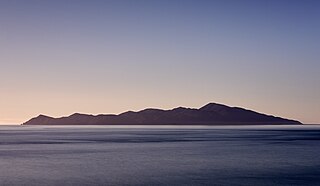
Kapiti Island, sometimes written as Kāpiti Island, is an island nature reserve located 5.6 km (3 mi) off the west coast of the lower North Island of New Zealand and within the Kāpiti Coast District. Parts of the island were previously farmed, but it is now a predator-free sanctuary for endemic birds, including many endangered birds. The island is 10 km (6.2 mi) long, running southwest/northeast, and roughly 2 km (1.2 mi) wide, being more or less rectangular in shape, and has an area of 19.65 km2 (7.59 sq mi).
Forest & Bird, also known by its formal name as the Royal Forest and Bird Protection Society of New Zealand, is an environmental organisation specialising in the protection and conservation of New Zealand's indigenous flora and fauna and unique wild places and natural ecosystems. Forest & Bird consists of 47 branches located in urban and rural centres throughout New Zealand. Branches are actively engaged in conservation projects and advocacy on a community, regional and national basis. Forest & Bird has offices and staff located in Auckland, Christchurch, Wellington, Nelson and Dunedin. Forest & Bird publishes a quarterly magazine Forest & Bird, one of New Zealand's definitive natural history and conservation publications.

Kahurangi National Park in the northwest of the South Island of New Zealand is the second largest of the thirteen national parks of New Zealand. It was gazetted in 1996 and covers 5,193 km2 (2,005 sq mi), ranging from the Buller River near Murchison in the south, to the base of Farewell Spit in Golden Bay in the north. The park has no single dominant landform, but includes an unusually wide variety of landscapes, including mountain ranges, rivers, gorges, raised peneplains and karst features such as caves and arches. Many of the landforms within the park are considered to be nationally or internationally significant.

Abel Tasman National Park is a national park at the north end of New Zealand's South Island. It covers 237.1 km2 (91.5 sq mi) of land between Golden Bay / Mohua and Tasman Bay / Te Tai-o-Aorere, making it the smallest of New Zealand's national parks. Despite this, the park is one of the most visited, partially due to the popularity of the Abel Tasman Coast Track which spans 60 km (37 mi) along the eastern and northern coastal areas of the park.
Environment and Conservation Organisations of Aotearoa New Zealand (ECO) was formed in 1971 under the name of CoEnCo. The name changed to ECO in 1976.
This is a timeline of environmental history of New Zealand. It includes notable events affecting the natural environment of New Zealand as a result of human activity.

Protected areas of New Zealand are areas that are in some way protected to preserve their environmental, scientific, scenic, historical, cultural or recreational value. There are about 10,000 protected areas, covering about a third of the country. The method and aims of protection vary according to the importance of the resource and whether it is publicly or privately owned.

Conservation in New Zealand has a history associated with both Māori and Europeans. Both groups of people caused a loss of species and both altered their behaviour to a degree after realising their effect on indigenous flora and fauna.

Secretary Island is an island in southwestern New Zealand, lying entirely within Fiordland National Park. Roughly triangular in shape, it lies between Doubtful Sound / Patea in the south and Te Awa-o-Tū / Thompson Sound in the north, with its west coast facing the Tasman Sea. To the east of the island, Pendulo Reach connects Te Awa-o-Tū / Thompson Sound with Doubtful Sound / Patea. Steeply sloped, the entirely bush-clad island rises to a chain of several peaks higher than 1000 metres. The highest of these is the 1,196-metre (3,924 ft) Mount Grono, the highest peak in the main New Zealand chain not located in the North or South Island. The island also contains three lakes. The largest, Secretary Lake, over 600 metres (2,000 ft) long, is located beneath Mount Grono at an altitude of 550 metres (1,800 ft).

Pūkaha National Wildlife Centre is a captive breeding facility and visitor centre located in a protected forest area on State Highway 2 in New Zealand's Tararua district. It was formerly called Mount Bruce National Wildlife Centre, then Pūkaha / Mount Bruce National Wildlife Centre.
The birds of New Zealand evolved into an avifauna that included many endemic species found in no other country. As an island archipelago, New Zealand accumulated bird diversity, and when Captain James Cook arrived in the 1770s he noted that the bird song was deafening.

The environment of New Zealand is characterised by an endemic flora and fauna which has evolved in near isolation from the rest of the world. The main islands of New Zealand span two biomes, temperate and subtropical, complicated by large mountainous areas above the tree line. There are also numerous smaller islands which extend into the subantarctic. The prevailing weather systems bring significantly more rain to the west of the country. New Zealand's territorial waters cover a much larger area than its landmass and extend over the continental shelf and abyssal plateau in the South Pacific Ocean, Tasman Sea and Southern ocean.

Deforestation in New Zealand has been a contentious environmental issue in the past, but native forests now have legal protection, and are not allowed to be tampered with by humans.

Forestry in New Zealand has a history starting with European settlement in the 19th century and is now an industry worth seven percent of annual revenue. Much of the original native forest cover was burnt off and logged, however forests have been extensively planted, predominantly with fast-growing cultivars of the Monterey Pine. Wood chips, whole logs, lumber and paper products are exported from New Zealand.

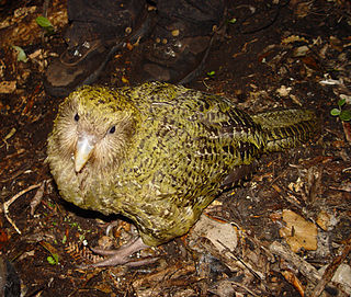
The North Island kōkako is an endangered forest bird which is endemic to the North Island of New Zealand. It is grey in colour, with a small black mask. It has blue wattles. Because of its wattle, the bird is sometimes locally called the blue-wattled crow, although it is not a corvid.
Ngā Uruora - Kāpiti Project is a community conservation project set up in Paekākāriki, New Zealand in 1997 by Fergus Wheeler. It is named after the book Ngā Uruora: The Groves of Life - Ecology & History in a New Zealand Landscape by ecologist Geoff Park. The main aims of Ngā Ururoa are protecting and restoring the Kāpiti Coast's unique kohekohe forest, re-establishing forests through planting programmes, and undertaking pest and weed control.

Hapuakohe Range of hills is aligned north–south, between the Waikato River and the Hauraki Plains in the Waikato region of New Zealand. It is separated from the Taupiri Range by an air-gap at Mangawara, where the Waikato flowed about 20,000 years ago.

Barbara Jean Mitcalfe née Fougère was a New Zealand conservationist, botanist and educator. She is best known for being an expert field botanist, for her conservation work in and around the Wellington region, and for helping to establish the first Māori preschool.
References
- ↑ Smith, Ian (1997). The State of New Zealand's Environment 1997. Rowan Taylor (ed.). Wellington, N.Z: Ministry for the Environment. ISBN 0478090005.
- ↑ "Tasman Forestry Ltd protects native forests" (PDF), N.Z. Forestry: 9, August 1989
- ↑ Cromarty, P.; Scott, D.A, eds. (1995). A Directory of Wetlands in New Zealand (PDF). Wellington: Department of Conservation. pp. 184–185. ISBN 0-478-01776-6.