Tasmania is an island state of Australia. It is located 240 kilometres (150 miles) to the south of the Australian mainland, separated from it by the Bass Strait, with the archipelago containing the southernmost point of the country. The state encompasses the main island of Tasmania, the 26th-largest island in the world, and the surrounding 1000 islands. It is Australia's least populous state, with 569,825 residents as of December 2021. The state capital and largest city is Hobart, with around 40 percent of the population living in the Greater Hobart area. This makes it Australia's most decentralised state.

The University of Tasmania (UTAS) is a public research university, primarily located in Tasmania, Australia. Founded in 1890, it is Australia's fourth oldest university. Christ College, one of the university's residential colleges, first proposed in 1840 in Lieutenant-Governor Sir John Franklin's Legislative Council, was modelled on the Oxford and Cambridge colleges, and was founded in 1846, making it the oldest tertiary institution in the country. The university is a sandstone university, a member of the international Association of Commonwealth Universities, and the Association of Southeast Asian Institutions of Higher Learning.

The Parliament of Tasmania is the bicameral legislature of the Australian state of Tasmania. It follows a Westminster-derived parliamentary system and consists of the governor of Tasmania, the Tasmanian House of Assembly, and Tasmanian Legislative Council. Since 1841, both Houses have met in Parliament House, Hobart. The Parliament of Tasmania first met in 1856.
Government House, Hobart, is the home and official residence of the governor of Tasmania, Australia. The palatial house is located on Lower Domain Road in the Queens Domain, near the Royal Tasmanian Botanical Gardens. There have been three Government Houses, all in Hobart.

The State Library of Tasmania is the reference, special collections, research and public lending library in the Tasmanian capital of Hobart, Australia. It is part of Libraries Tasmania. Libraries Tasmania includes a state-wide network of library services, community learning, adult literacy and the State’s archives and heritage services.

SS Lake Illawarra was a handysize bulk carrier of 7,274 tons in the service of the Australian National Line. This ship is known for causing the Tasman Bridge disaster when she collided with pylon 19 of Hobart's giant high concrete arch style Tasman Bridge on the evening of 5 January 1975 at 9.27 pm, resulting in the deaths of 12 people.
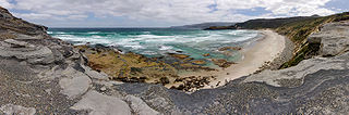
The South Coast Track is a bushwalking track located in the South Coast region of Tasmania, Australia. The 85-kilometre (53 mi) track traverses remote wilderness within the Southwest National Park, part of the Tasmanian Wilderness World Heritage Site, and is managed as a wilderness walk. The Tasmanian Parks & Wildlife Service recommend that experienced bushwalkers can take six-to-eight days to cover the track in one direction.

The Tasmanian Museum and Art Gallery (TMAG) is a museum located in Hobart, Tasmania. The museum was established in 1846, by the Royal Society of Tasmania, the oldest Royal Society outside England. The TMAG receives 400,000 visitors annually.

The Maritime Museum of Tasmania is a privately operated maritime museum dedicated to the history of Tasmania's association with the sea, ships, and ship-building, and is located at Carnegie House in Sullivans Cove, Hobart, Tasmania.
The Lindisfarne Interchange is a Directional T interchange which connects the Tasman Bridge to the Tasman Highway and the East Derwent Highway, on the eastern shore of the River Derwent within Hobart, Tasmania. The Interchange was constructed in 1960 in conjunction with the Tasman Bridge and opened to Traffic on 23 December 1964.

East Island is a granite island, with an area of 12.42 ha, in south-eastern Australia. It is part of Tasmania’s Hogan Group, lying in northern Bass Strait between the Furneaux Group and Wilsons Promontory in Victoria.

Sloping Island, incorporating the adjacent Sloping Reef, is an island nature reserve, with an area of 117 ha, in Tasmania in south-eastern Australia. It is part of the Sloping Island Group, lying close to the south-eastern coast of Tasmania around the Tasman and Forestier Peninsulas.

Smooth Island, is a privately owned island with an area of 59.31 ha lying close to the south-eastern coast of Tasmania, Australia. The island is part of the Sloping Island Group situated in Norfolk Bay and surrounded by the Tasman and Forestier Peninsulas. The towns Dunalley and Murdunna are nearby. Smooth Island differs from other Tasmanian islands as it has an unencumbered freehold title down to the high-water mark.
Fulham Island is a privately owned island with an area of 10 hectares. It is part of the Sloping Island Group, lying close to the south-eastern coast of Tasmania around the Tasman and Forestier Peninsulas in Tasmania, Australia.
The Hope Island, part of the Partridge Island Group, is a small island that lies close to the south-eastern coast of Tasmania, Australia. The island is located in the D'Entrecasteaux Channel between Bruny Island and the Tasmanian mainland. Its neighbouring islets are named Faith and Charity, and also the Arch Rock.
The Sloping Island Group is a group of small islands in south-eastern Tasmania in Australia. They lie close to the south-eastern coast of Tasmania around the Tasman and Forestier Peninsulas.

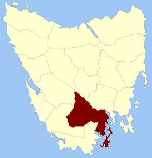
Buckland is a rural locality in the local government area (LGA) of Glamorgan–Spring Bay in the South-east LGA region of Tasmania. The locality is about 25 kilometres (16 mi) south-west of the town of Triabunna. The 2016 census has a population of 179 for the state suburb of Buckland. It is a village on the Tasman Highway. It contains a historic church, St John the Baptist church.

The South-east Tasmania Important Bird Area encompasses much of the land retaining forest and woodland habitats, suitable for breeding swift parrots and forty-spotted pardalotes, from Orford to Recherche Bay in south-eastern Tasmania, Australia.

The Hope and Anchor Tavern is an Australian pub in Hobart, Tasmania. Built in 1807, it is the oldest continually licensed pub in Australia. However, The Bush Inn in New Norfolk claims to be the oldest operating Australian pub, because their venue has operated continuously since it opened in 1815 whereas the Hope and Anchor Tavern has had periods of closure since opening in 1807. The Hope and Anchor Tavern is referred to in Captain A E Sykes: memoirs.