
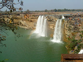
The Godavari is India's second longest river after the Ganga river and drains the third largest basin in India, covering about 10% of India's total geographical area. Its source is in Trimbakeshwar, Nashik, Maharashtra. It flows east for 1,465 kilometres (910 mi), draining the states of Maharashtra (48.6%), Telangana (18.8%), Andhra Pradesh (4.5%), Chhattisgarh (10.9%) and Odisha (5.7%). The river ultimately empties into the Bay of Bengal through an extensive network of distributaries. Measuring up to 312,812 km2 (120,777 sq mi), it forms one of the largest river basins in the Indian subcontinent, with only the Ganga and Indus rivers having a larger drainage basin. In terms of length, catchment area and discharge, the Godavari is the largest in peninsular India, and had been dubbed as the Dakshina Ganga.

East Godavari is a district in the Coastal Andhra region of Andhra Pradesh, India. Its district headquarters is at Rajamahendravaram.

Rajahmundry, officially known as Rajamahendravaram, is a city in the Indian state of Andhra Pradesh and district headquarters of East Godavari district. It is the fifth most populated city in the state. During British rule, the district of Rajahmundry was created in the Madras Presidency in 1823. It was reorganised in 1859 and bifurcated into the Godavari and Krishna districts. Rajahmundry was the headquarters of Godavari district, which was further bifurcated into East Godavari and West Godavari districts in 1925. When the Godavari district was bifurcated, Kakinada became the headquarters of East Godavari and Eluru the headquarters of West Godavari. It is administered under Rajahmundry revenue division of the East Godavari district. The city is known for its floriculture, history, culture, agriculture, economy, tourism, and its heritage. It is known as the "Cultural Capital of Andhra Pradesh".

The West Godavari district is a coastal district in the Indian state of Andhra Pradesh with an administrative headquarters in Bhimavaram. As of the 2011 Census of India, the district has an area of 2,178 km2 (841 sq mi) and a population of 1,779,935. It is bounded by the Krishna district and Bay of Bengal to the south, East Godavari district to the east, and Eluru district, Kolleru Lake and Upputeru Drain to the northwest.
Indravati River is a tributary of the Godavari River, in central India.

The Sriram Sagar Project is also known as the Pochampadu Project is an Indian flood-flow project on the Godavari. The Project is located in Nizamabad district, 3 km away from National Highway 44. It has been described by The Hindu as a "lifeline for a large part of Telangana".
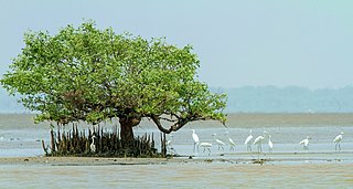
Coringa Wildlife Sanctuary is an estuary situated near Kakinada in Andhra Pradesh, India. It is the third largest stretch of mangrove forests in India with 24 mangrove tree species and more than 120 bird species. It is home to the critically endangered white-backed vulture and the long billed vulture. Mangroves are a group of trees and shrubs that live in the coastal intertidal zone, with a dense tangle of prop roots that make the trees appear to be standing on stilts above the water. This tangle of roots allows the trees to handle the daily rise and fall of tides; hence, the mangrove forest gets flooded at least twice per day. The roots also slow the movement of tidal waters, causing sediments to settle out of the water and build up the muddy bottom.

Mukteswaram is a village located in Ainavilli Mandal, Konaseema Delta, Amalapuram revenue division in Konaseema district of Andhra Pradesh, India. It is situated near the River Gautami-Godavari, a tributary to the Godavari. Mukteswaram is one of the three important Ferry points for Kotipalli-Mukteswaram and the other two being; Bodasakurru-Pasarlapudi and Sakhinetipalli-Narasapuram in the Konaseema region. Mukteswaram is 60 km from Kakinada.

Kotipalli also known as Koti Theertham is a village located in K. Gangavaram mandal of Ramachandrapuram revenue division in Konaseema district of Andhra Pradesh, India. The temple town is also known as Kumararama of the Pancharama Kshetras, and is located 15 km from Amalapuram. Every year festivals such as Maha Sivaratri, Vaisakha Suddha Ekadasi, Aswayuja Suddha Padyami to Dwadasi and Ksheerabdi Dwadasi Teppotsavam are celebrated in this village.
Rajahmundry Rural mandal, officially known as Rajamahendravaram Rural mandal, is one of the 19 mandals in East Godavari district of the state of Andhra Pradesh, India. The mandal is bounded by Seethanagaram mandal, Korukonda mandal, Rajanagaram mandal, Kadiam mandal and Atreyapuram mandal.

The Manjara River is a tributary of the river Godavari. It passes through the states of Maharashtra, Karnataka and Telangana. It originates in the Balaghat range of hills near the Ahmednagar district at an altitude of 823 metres (2,700 ft) and empties into the Godavari River. It has a total catchment area of 30,844 square kilometres (3,084,400 ha). This river is one of the Triveni Sangam.
Seethanagaram is one of the 19 mandals in East Godavari district of the state of Andhra Pradesh, India. Its headquarters are located at Seethanagaram. The mandal is bounded by Devipatnam mandal, Korukonda mandal, Rajahmundry (rural) mandal and a part of it lies on the banks of Godavari River. It is sub urban growth of Rajamahendravaram City.
Rajolu, Rajavolu, Razole may refer to:
National Highway 216 is a National Highway in the Indian state of Andhra Pradesh. The former highways of NH 214 and 214A were merged and renumbered as NH 216. It starts from NH 16 junction at Kattipudi and passes through Kakinada, Amalapuram, Digamarru (Palakollu), Narasapuram, Machilipatnam, Repalle, Cherukupalle, Bapatla, Chirala before it junctions NH 16 again at Ongole. Visakhapatnam–Kakinada Petro Chemical Corridor, is a proposed project along the highway.

Taliperu is a river in the Godavari system originating in the Bijapur District of Chhattisgarh. It is a left-bank tributary of Godavari River, draining into it through a confluence located near Cherla in the Khammam District in Telangana.
Darna is a minor left-bank tributary of Godavari in the Nashik District, Maharashtra, India. Rising north of the Kalsubai range, it drains Igatpuri, Nashik and Niphad Talukas of Nashik District. The conjunction with Godavari is situated at Darnasangvi.
Godawari Dutta is an Indian painter, well known for Madhubani Painting and patron of Mithila Kala Vikas Samiti. She was awarded India's fourth highest civilian award the Padma Shri.
Tummidihetti Barrage is a proposed barrage across Pranhita River, a tributary of Godavari River at Tummidihetti village, Koutala mandal, Adilabad district of Telangana State. The project will provide irrigation facilities for an ayacut of 2,00,000 acres in drought prone areas in East Adilabad District of Telangana State..

Eluru district is a district in coastal Andhra Region in the Indian state of Andhra Pradesh. With Eluru as its administrative headquarters, it was proposed on 26 January 2022 to become one of the resultant twenty six districts in the state once a final notification is issued by the government of Andhra Pradesh. It is formed from Eluru revenue division and Jangareddygudem revenue division from West Godavari district and Nuzvid revenue division from Krishna district.

Dr. B. R. Ambedkar Konaseema district is one of the 26 districts in the Indian state of Andhra Pradesh. It is situated between the tributaries of the Godavari river in the Konaseema region of Coastal Andhra. It was carved out of East Godavari district on 4 April 2022 by the Government of Andhra Pradesh. Amalapuram is the district headquarters and the largest city in this district. The district shares boundaries with West Godavari, East Godavari and Kakinada districts.

