
The Tooloom National Park is a protected national park located in the Northern Rivers region of New South Wales, Australia. The 4,380-hectare (10,800-acre) part is situated approximately 616 kilometres (383 mi) north of Sydney and 20 kilometres (12 mi) from the border town of Urbenville.
Cudgegong River, a perennial stream that is part of the Macquarie catchment within the Murray–Darling basin, is located in the central western and Orana districts of New South Wales, Australia.

Coolangatta is a coastal suburb in the City of Gold Coast, Queensland, Australia. It is the Gold Coast's southernmost suburb and it borders New South Wales. In the 2016 census, Coolangatta had a population of 5,948 people.
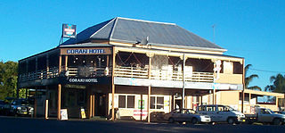
Coraki is a small town that sits on the confluence of the Richmond and Wilsons Rivers in northern New South Wales, Australia in Richmond Valley Shire. At the 2021 census, Coraki had a population of 1,277 people.
Little River (Dubbo), a watercourse of the Macquarie catchment within the Murray–Darling basin, is located in the central western and Orana districts of New South Wales, Australia.

Suffolk Park is a suburb in the Byron Shire of the Northern Rivers region in New South Wales, Australia. It is 5 km south of Byron Bay. At the 2021 Census, its population was 4,222.

Wilson River, a perennial river of the Hastings River catchment, is located in the Mid North Coast region of New South Wales, Australia.

Billinudgel is a town in the Northern Rivers region of New South Wales, Australia, and is part of Byron Shire. It used to be a railway town with many fruit and vegetables loaded onto the local railway. Since the railway is no longer used in Billinudgel, it has nearly joined to the nearby town of Ocean Shores. The area was bypassed by a heavily upgraded Pacific Highway in July 2007, home to the NSW RFS Billinudgel/Ocean Shores Brigade from 1976.
Tabulam is a rural village in the far north-east of New South Wales, Australia, 800 kilometres from the state capital, Sydney. Tabulam is located on the Bruxner Highway between Tenterfield and Casino and on the Clarence River. According to the 2016 census, there were 470 people living in Tabulam. The main village is administered by Kyogle Council, while the section of Tabulam west of the Clarence River is part of Tenterfield Shire.
Tomki is a locality in northern New South Wales, Australia in Richmond Valley Shire. The name Tomki is derived from Bundjalung damgay, meaning "greedy".
Dora creek is a watercourse that is located in Greater Newcastle in the Hunter region of New South Wales, Australia.
Macquarie Rivulet is a perennial river located in the Southern Highlands and Illawarra regions of New South Wales, Australia.

Angels Beach is a surfing beach on the Pacific Ocean on the north coast of New South Wales, Australia.

Barnard River, a perennial river of the Manning River catchment, is located in the Northern Tablelands and Mid North Coast districts of New South Wales, Australia.
Crudine River, a watercourse that is part of the Macquarie catchment within the Murray–Darling basin, is located in the central western district of New South Wales, Australia.

Esk River, a perennial stream that is part of the Clarence River catchment, is located in the Northern Rivers region of New South Wales, Australia.
Tumbarumba Creek, a watercourse of the Murray catchment within the Murray–Darling basin, is located in the region bordering the Riverina and Australian Alps of New South Wales, Australia.

The Back Creek, a perennial stream of the Richmond River catchment, is located in Northern Rivers region in the state of New South Wales, Australia.
The Eden Creek, a perennial stream of the Richmond River catchment, is located in Northern Rivers region in the state of New South Wales, Australia.
Dingo Creek, a perennial stream of the Manning River catchment, is located in the Mid North Coast region of New South Wales, Australia.