Tabuaeran, also known as Fanning Island, is an atoll that is part of the Line Islands of the central Pacific Ocean and part of Kiribati. The land area is 33.73 square kilometres, and the population in 2015 was 2,315. The maximum elevation is about 3 m (10 ft) above high tide.

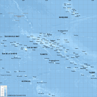
Penrhyn is an atoll in the northern group of the Cook Islands in the south Pacific Ocean. The northernmost island in the group, it is located at 1,365 km (848 mi) north-north-east of the capital island of Rarotonga, 9 degrees south of the equator. Its nearest neighbours are Rakahanga and Manihiki, approximately 350 kilometres (220 mi) to the southwest. Once one of the most heavily populated atolls, it was almost completely depopulated by Peruvian slavers in 1864.
Manihi, or Paeua, is a coral atoll in the Tuamotu Archipelago, part of French Polynesia. It is one of the northernmost of the Tuamotus, located in the King George subgroup. The closest land to Manihi is Ahe Atoll, located 14 km to the west. The population is 650 inhabitants.

Rakahanga is part of the Cook Islands, situated in the central-southern Pacific Ocean. The unspoilt atoll is 1,248 kilometres from the Cook Islands' capital, Rarotonga, and lies 1,111 kilometres south of the equator. Its nearest neighbour is Manihiki which is just 44 kilometres away. Rakahanga's area is 4 square kilometres (1.5 sq mi). Its highest point is approximately 5 metres above sea level. The population was 83 in the 2016 Census of Population & Dwellings. Since 2014 Rakahanga's power has been 100% solar generated. The Rakahanga-Manihiki language differs from Cook Islands Maori.

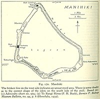
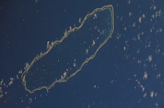
Manihiki is an atoll in the northern group of the Cook Islands known informally as the "Island of Pearls". It is located in the Northern Cook Island chain, approximately 1,299 kilometres (807 mi) north of the capital island of Rarotonga, making it one of the most remote inhabitations in the Pacific Ocean. Its name has two possible meanings: It's believed that the original name of the island was Manuhiki, inspired by the aboriginal discovers Manu coming from the word Rua Manu and Hiki meaning ashore, so the literal translation would be canoe carried ashore. The second interpretation is that the original discoverers were from Manihi, an island in Tuamotus, so the name of the island would mean Little Manihi.

Raraka, or Te Marie, is an atoll in the west of the Tuamotu group in French Polynesia. It lies 17 km to the southeast of Kauehi Atoll.

The Northern Cook Islands is one of the two chains of atolls which make up the Cook Islands. Lying in a horizontal band between 9° and 13°30' south of the Equator, the chain consists of the atolls of Manihiki, Nassau, Penrhyn, Pukapuka, Rakahanga and Suwarrow, along with the submerged Tema Reef.

Pinipel Island, also known as Green Island, is the northern of the two atolls making up the Green Islands, east of New Ireland, Papua New Guinea. It is located north of Nissan Island, the southern atoll. It is about 330 feet (101 m) high and cliffy, from 200 to 500 yards wide, except at the north end.

Tukao is a village on Manihiki atoll in the Cook Islands. The village is at the northern tip of the islet of Ngake, which runs along the northern-eastern side of the atoll.
Ngake is one of 43 islands in the Manihiki atoll of the Cook Islands. It is the largest island, making up almost the entire north-eastern side of the atoll. The village of Tukao and Manihiki Island Airport are both located on the island.
Atimono is one of 43 islands in the Manihiki atoll of the Cook Islands. It is a small islet at the southern end of Ngake and to the north of Motu Hakamaru.
Motu Hakamaru is one of 43 islands in the Manihiki atoll of the Cook Islands. It is a small islet and marks the south-eastern corner of the atoll.
Porea is one of 43 islands in the Manihiki atoll of the Cook Islands. It is a small islet which marks the southern edge of the atoll. It is separated from Tauhunu in the west and Motu Hakamaru by a large number of small islets.
Te Puka is one of 43 islands in the Manihiki atoll of the Cook Islands. It is a small islet in the south-west corner of the atoll, just inside the reef from Tauhunu.
Murihiti is one of 43 islands in the Manihiki atoll of the Cook Islands. It is a small island, in the gap in the atoll between Tauhunu and Ngake.

Te Kainga is one of 11 islands in the Rakahanga atoll of the Cook Islands. The island once served as the principal inhabited island of Rakahanga, but the settlement was moved to Rakahanga Island in the missionary era. The single village was shared by the atoll's four tribes, and was surrounded by five marae: Punariku, Avarua, Huku-wananga, Mua, and Variu.
Mahuta is one of 11 islands in the Rakahanga atoll of the Cook Islands. It is on the east of the atoll, between the islets of Huananui and Okakara.
Okakara is one of 11 islands in the Rakahanga atoll of the Cook Islands. It is on the east of the atoll, between the islets of Mahuta and Rakahanga Island.
Akaro is one of 11 islands in the Rakahanga atoll of the Cook Islands. It is on the east of the atoll, between the islets of Tetukono and Okakara.