Uppsala is the capital of Uppsala County and the fourth-largest city in Sweden, after Stockholm, Gothenburg, and Malmö. It had 168,096 inhabitants in 2017.
New Sweden was a Swedish colony, along the lower reaches of the Delaware River, in North America, from 1638 to 1655, established during the Thirty Years' War, when Sweden was a military great power. New Sweden was part of Swedish colonization efforts in the Americas.

The Great Northern War (1700–1721) was a conflict in which a coalition led by the Tsardom of Russia successfully contested the supremacy of the Swedish Empire in Northern, Central and Eastern Europe. The initial leaders of the anti-Swedish alliance were Peter I of Russia, Frederick IV of Denmark–Norway and Augustus II the Strong of Saxony–Poland–Lithuania. Frederick IV and Augustus II were defeated by Sweden, under Charles XII, and forced out of the alliance in 1700 and 1706 respectively, but rejoined it in 1709 after the defeat of Charles XII at the Battle of Poltava. George I of Great Britain and of Brunswick-Lüneburg (Hanover) joined the coalition in 1714 for Hanover and in 1717 for Britain, and Frederick William I of Brandenburg-Prussia joined it in 1715.

Porvoo is a city and a municipality situated on the southern coast of Finland approximately 50 kilometres (30 mi) east of Helsinki. It is one of the six medieval towns in Finland, first mentioned as a city in texts from the 14th century. Porvoo is the seat of the Swedish-speaking Diocese of Borgå of the Evangelical Lutheran Church of Finland.
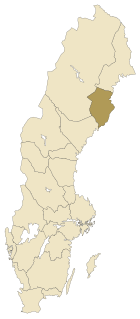
Norrbotten County is the northernmost county or län of Sweden. It borders Västerbotten County to the southwest, the Gulf of Bothnia to the southeast. It also borders the counties of Nordland and Troms in Norway to the northwest, and Lapland Province in Finland to the northeast.

Ångermanland (help·info) is a historical province (landskap) in the northern part of Sweden. It is bordered by Swedish Lapland, Västerbotten, the Gulf of Bothnia, Medelpad and Jämtland. Prince Nicolas of Sweden is Duke of Ångermanland.

Swedish Pomerania was a Dominion under the Swedish Crown from 1630 to 1815, situated on what is now the Baltic coast of Germany and Poland. Following the Polish War and the Thirty Years' War, Sweden held extensive control over the lands on the southern Baltic coast, including Pomerania and parts of Livonia and Prussia.
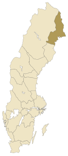
Norrbotten, known in English as North Bothnia, is a Swedish province (landskap) in northernmost Sweden. It borders south to Västerbotten, west to Swedish Lapland, and east to Finland.

Delaware Colony in the North American Middle Colonies consisted of land on the west bank of the Delaware River Bay. In the early 17th century the area was inhabited by Lenape and possibly the Assateague tribes of Native Americans. The first European settlers were the Swedes and the Dutch, but the land fell under English control in 1664. William Penn was given the deed to what was then called "the Lower Counties on the Delaware" by the Duke of York, in a deed separate from that which he held for the larger Province of Pennsylvania. Delaware was then governed as part of Pennsylvania from 1682 until 1701, when the Lower Counties petitioned for and were granted an independent colonial legislature, though the two colonies shared the same governor until 1776, when Delaware's assembly voted to break all ties with both Great Britain and Pennsylvania.

The Torne, also known as the Tornio, is a river in northern Sweden and Finland. For approximately half of its length it defines the border between these two countries. It rises at Lake Torne near the border with Norway and flows generally southeast for a distance of 522 kilometres (324 mi) into the Gulf of Bothnia. It is the largest river in Norrbotten both by length and by watershed area.
The Treaties of Stockholm are two treaties signed in 1719 and 1720 that ended the war between Sweden and an alliance of Hanover and Prussia.
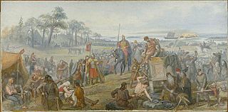
Fyrisvellir, Fyris Wolds or Fyrisvallarna was the marshy plain (vellir) south of Gamla Uppsala where travellers had to leave the ships on the river Fyris (Fyrisån) and walk to the Temple at Uppsala and the hall of the Swedish king.

Umeå is a city in north east Sweden. It is the seat of Umeå Municipality and the capital of Västerbotten County. The city is located on the Ume River.
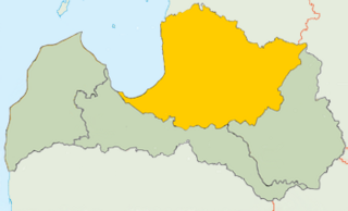
Vidzeme is one of the historical and cultural regions of Latvia. Literally meaning "the Middle Land", it is situated in north-central Latvia north of the Daugava River. Sometimes in German, it is also known as Livland, the German form from Latin Livonia, though it comprises only a small part of Medieval Livonia and about half of Swedish Livonia.

The Treaty of Stettin of 4 May 1653 settled a dispute between Brandenburg and Sweden, who both claimed succession in the Duchy of Pomerania after the extinction of the local House of Pomerania during the Thirty Years' War. Brandenburg's claims were based on the Treaty of Grimnitz (1529), while Sweden's claims were based on the Treaty of Stettin (1630). The parties had agreed on a partition of the Swedish-held duchy in the Peace of Westphalia (1648), and with the Treaty of Stettin determined the actual border between the partitions. Western Pomerania became Swedish Pomerania, Farther Pomerania became Brandenburgian Pomerania.

Rostojávri (Northern Sami), Råstojaure (Swedish), or Store Rostavatn (Norwegian) is a lake on the border between Norway and Sweden. The Norwegian side of the lake is located in Målselv Municipality in Troms county and the Swedish side of the lake is located in Kiruna Municipality in Norrbotten County. The Norwegian part of the lake lies inside Øvre Dividal National Park. The lake lies at an elevation of 680 metres (2,230 ft) and covers a total area of 34.24 square kilometres (13.22 sq mi); with 3.67 square kilometres (1.42 sq mi) located in Norway and the remaining 30.57 square kilometres (11.80 sq mi) are located in Sweden.

Tverrvatnet or Tvervatnet [tvær'vatne] is a lake in the municipality of Rana in Nordland county, Norway. The European route E12 highway passes along the northern and eastern shores of the lake between the town of Mo i Rana and the border with Sweden. Tverrvatnet gets its name from the fact that it is located "across", in a north-south direction, while most lakes in Rana are located in an east-west direction.

The VegaExpedition of 1878–1880, named after the SS Vega and under the leadership of Adolf Erik Nordenskiöld, was the first Arctic expedition to navigate through the Northeast Passage, the sea route between Europe and Asia through the Arctic Ocean, and the first voyage to circumnavigate Eurasia. Initially a troubled enterprise, the successful expedition is considered to be among the highest achievements in the history of Swedish science.