
The Arctic Archipelago, also known as the Canadian Arctic Archipelago, is a group of islands north of the Canadian mainland.

The Gulf of Bothnia is the northernmost arm of the Baltic Sea. It is situated between Finland's west coast and Sweden's east coast. In the south of the gulf lie the Åland Islands, between the Sea of Åland and the Archipelago Sea.

The Celebes Sea of the western Pacific Ocean is bordered on the north by the Sulu Archipelago and Sulu Sea and Mindanao Island of the Philippines, on the east by the Sangihe Islands chain, on the south by Sulawesi's Minahassa Peninsula, and on the west by Kalimantan in Indonesia. It extends 420 miles (675 km) north-south by 520 mi (840 km) east-west and has a total surface area of 110,000 square miles (280,000 km2), to a maximum depth of 20,300 feet (6,200 m). The sea opens southwest through the Makassar Strait into the Java Sea.

Ernst Krenkel Observatory, also known as Kheysa, was a former Soviet rocket launching site located on Heiss Island, Franz Josef Land. It is named after a famous Arctic explorer Ernst Krenkel, a member of the crew of the North Pole-1 drift ice station and other notable Soviet polar expeditions.

Pathiramanal is a small island inMuhamma panchayat of Alappuzha district. The name Pathiramanal means 'sands of night'. The scenic beauty of both sides of the lake as well as that of the island is mind blowing. It is home to many rare varieties of migratory birds from different parts of the world.
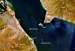
The Bab Iskender (Arabic: باب اسكندر Iskander's Strait, also variously known as the Eastern strait, the small strait, the narrow pass or the small pass, is the eastern section of the Bab-el-Mandeb straits, which separates Ras Menheli, Yemen, on the Arabian Peninsula from Ras Siyyan, Djibouti, on the Horn of Africa. The strait is 2 miles wide and 16 fathoms deep. The Yemeni island of Perim divides the strait into two channels, Bab Iskender and Dact-el-Mayun respectively.

Hooker Island is one of the central islands of Franz Josef Land. It is located in the central area of the archipelago at 80.23°N 53.02°E. It is administered by the Arkhangelsk Oblast, Russia.

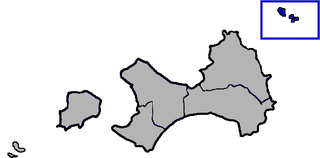
Estádio Marcelo Leitão is a multi-use stadium in Sal Island, Cape Verde. It is used mostly for football matches and now track and field and has a capacity of 8,000 people. It is named for Marcelo Leitão, one of the two main features on the island, the other is a square located in Santa Maria. The stadium is owned by the municipality of Sal and still does as the municipality has yet to split into two. The stadium are operated by the Sal Regional Football (Soccer) and Athletic associations. It is the home stadium of Espargos teams, Académico do Aeroporto and others based in a neighborhood Juventude and recently Chã de Matias, Gaviões, Jovens Unidos of Ribeira Funda and Pretória, it is also home to the island's club Académica do Sal. The ground is made of artificial grass, its area is 105 x 68 meters. Its location is south of the road connecting the east of the city with the road encircling most of the city. The stadium also had recently constructed parking lots.

Cay Sal Bank is the third largest and the westernmost of the Bahama Banks. It is located between 23º27'N - 24º10'N and 079º25'W – 080º35'W. In a geographical sense, it is separate from the Bahamas proper as it is much closer to Cuba than to the closest Bahamanian island. It is separated by Santaren Channel from the Great Bahama Bank, the western rim of which is 50 km (31 mi) to the east. The Straits of Florida separate it from the United States mainland and the Florida Keys.

Narang, Kunar, Afghanistan نرنګ in Pashto and Persian is situated in the central part of Kunar Province, Afghanistan south of Asadabad. It is surrounded by high mountains and the Kunar River. The population is 36,700 (2014). The district center is the village of Kuz Narang at 742 m altitude. It is the kunar 2nd largest district regarding Agriculture Land. The irrigation system is under rehabilitation.The land is in much good condition and fertile. The irrigation system is almost the best in Kunar province. About 75% of the people are educated. The famous villages are: 1: Bar-Narhang 2: Kotkay 3: Badel dara 4: kuz-Narhang 5: Lamatak 6: dandona 7: Char qala 8: kodo ; etc

Rossøya, sometimes referred to as Ross Island in English, is an island located in the Arctic Ocean. It is a part of Sjuøyane, a group of islands in the Svalbard archipelago, some 20 km north of the coast of Nordaustlandet. Rossøya is located 100 m north-northwest of the somewhat larger island Vesle Tavleøya. The northern point of Rossøya, at 80° 49′ 44.41″ North, is the northernmost point in Svalbard, and thereby also in the Kingdom of Norway. The distance to the North Pole is 1024.3 kilometers, to Nordkapp on the Norwegian mainland 1084 km and to Pysen, off the southern tip of mainland Norway, 2580 km.

Sverdrup Island or Svordrup Island is an isolated island in the southern region of the Kara Sea. This island is covered with tundra vegetation. It is located 120 km north of Dikson on the Siberian coast. The nearest land mass is the Arkticheskiy Institut Islands, about 90 km to the northeast. The island has a wide bay opening towards the west. Its length is 15 km and its maximum width 10 km.
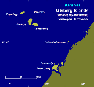
The Heiberg Islands, spelt Geyberg, Gejberg or Geiberg is a group of four small islands covered with tundra vegetation and with scattered stones on their shores. They lie in the Kara Sea, between the bleak coast of Siberia's Taymyr Peninsula and Severnaya Zemlya. These islands are between 35 and 45 km from the continental shore.
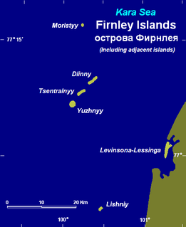
The Firnley Islands is a group of three small islands covered with tundra vegetation and with scattered stones on their shores. They lie in the Kara Sea, close to the bleak coast of Siberia's Taymyr Peninsula, not far east of the Nordenskjold Archipelago. These islands lie about 35 km from the continental shore.
Phippsøya is the largest island in Sjuøyane, an archipelago north of Nordaustlandet, Svalbard in Arctic Norway. It is located some 22 km north of Nordkapp on Svaldbard proper and 8.5 km south of Rossøya, the northernmost island of the Svalbard archipelago. Phippsøya is separated from Parryøya to the south by the 1.3 km wide Straumporten sound, from Martensøya to the southeast by the 1.1 km wide Trollsundet and from Tavleøya to the northwest by the 1 km wide Marmorsundet.
Vesle Tavleøya is the larger island of the two northernmost of Sjuøyane - the other being Rossøya, north of Nordaustlandet, Svalbard. Vesle Tavleøya is situated some 7 km northeast of Phippsøya, the largest island of the islands, separated by Sjuøyflaket sound.
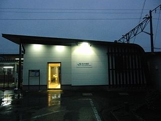
Minami-Nakagō Station is a JR East railway station located in Kitaibaraki, Ibaraki Prefecture, Japan.
Wuqiu is a group of islands comprising two major islands, namely Greater Qiu Islet and Smaller Qiu Islet, in the Taiwan Strait. Administratively, the Wuqiu Township is a rural township which is part of Kinmen County of the Fujian Province of the Republic of China (Taiwan). It is the smallest township in Kinmen County and is located more than 110 km northeast of the rest of the county. The People's Republic of China claims the Wuqiu Islands as part of Xiuyu District in the prefecture-level city of Putian in its own Fujian province.
Tauksi is an uninhabited Estonian island, located north of Puise peninsula in Matsalu National Park. Its area is about 2,5 km² and it is the 19th largest island of Estonia.


