Related Research Articles

Stow is a town in Middlesex County, Massachusetts, United States. The town is located 21 miles (34 km) west of Boston, in the MetroWest region of Massachusetts. The population was 7,174 at the 2020 census. Stow was officially incorporated in 1683 with an area of approximately 40 square miles (100 km2).

Maynard is a town in Middlesex County, Massachusetts, United States. The town is located 22 miles west of Boston, in the MetroWest and Greater Boston region of Massachusetts and borders Acton, Concord, Stow and Sudbury. The town's population was 10,746 as of the 2020 United States Census.

An arch bridge is a bridge with abutments at each end shaped as a curved arch. Arch bridges work by transferring the weight of the bridge and its loads partially into a horizontal thrust restrained by the abutments at either side, and partially into a vertical load on the arch supports. A viaduct may be made from a series of arches, although other more economical structures are typically used today.

Concrete bridges are a type of bridge, constructed out of concrete. They started to appear widely in the early 20th century.

The American Legion Memorial Bridge, also known as the South Cass Street Bridge, is a reinforced concrete arch bridge carrying South Cass Street over the Boardman River in Traverse City, Michigan. It was completed in 1930 and listed on the National Register of Historic Places in 2000.

The Assabet River is a small, 34.4-mile (55.4 km) long river located about 20 miles (30 km) west of Boston, Massachusetts, United States. The Assabet rises from a swampy area known as the Assabet Reservoir in Westborough, Massachusetts, and flows northeast before merging with the Sudbury River at Egg Rock in Concord, Massachusetts, to become the Concord River. The Organization for the Assabet, Sudbury and Concord Rivers, headquartered in West Concord, Massachusetts, is a non-profit organization dedicated to the preservation, protection, and enhancement of the natural and recreational features of these three rivers and their watershed. As the Concord River is a tributary of the Merrimack River, it and the Assabet and Sudbury rivers are part of the larger Merrimack River watershed.

The Columbia–Wrightsville Bridge, officially the Veterans Memorial Bridge, spans the Susquehanna River between Columbia and Wrightsville, Pennsylvania, and carries Pennsylvania Route 462 and BicyclePA Route S. Built originally as the Lancaster-York Intercounty Bridge, construction began in 1929, and the bridge opened September 30, 1930. On November 11, 1980, it was officially dedicated as Veterans Memorial Bridge, though it is still referenced locally as the Columbia–Wrightsville Bridge.

Frankford Creek is a minor tributary of the Delaware River in southeast Pennsylvania. It derived its name from today's Frankford, Philadelphia neighborhood.

Route 85 is a 21.01-mile-long (33.81 km) north–south state highway in Massachusetts, United States. It passes through the heart of Boston's MetroWest region, through towns on the eastern edge of Worcester County and western edge of Middlesex County, crossing the border between the two counties four times. Throughout its entire distance, Route 85 runs parallel to I-495, never passing more than two miles from it.

George Westinghouse Memorial Bridge in East Pittsburgh, Pennsylvania, carries U.S. Route 30, the Lincoln Highway, over the Turtle Creek Valley near to where it joins the Monongahela River Valley east of Pittsburgh. The reinforced concrete open-spandrel deck arch bridge has a total length of 1,598 feet (487 m) comprising five spans. The longest, central span is 460 feet (140 m), with the deck height 240 feet (73 m) above the valley floor, for a time the world's longest concrete arch span structure. It cost $1.75 million. The design engineers were Vernon R. Covell and George S. Richardson, with architectural design by Stanley Roush. The pylons at the ends of the bridges feature Art Deco reliefs by Frank Vittor.

The Isaac Lee Patterson Bridge, also known as the Rogue River Bridge and the Isaac Lee Patterson Memorial Bridge, is a concrete arch bridge that spans the Rogue River in Curry County, Oregon. The bridge was constructed by the Mercer Fraser Company of Eureka, California. The bridge carries U.S. Route 101 across the river, near the point where the river empties into the Pacific Ocean, and connects the towns of Gold Beach and Wedderburn. A bridge with strong Art Deco influences, the Isaac Lee Patterson Bridge is a prominent example of the designs of the Oregon bridge designer and highway engineer Conde McCullough. It was designated a National Historic Civil Engineering Landmark by the American Society of Civil Engineers in 1982. It is part of a series of notable bridges designed by McCullough for the Oregon Coast Highway in the 1930s. It was placed on the National Register of Historic Places in 2005.

Anderson Memorial Bridge connects Allston, a neighborhood of Boston, and Cambridge. The bridge stands on the site of the Great Bridge built in 1662, the first structure to span the Charles River. It brings Boston traffic into Harvard Square and was finished in 1915.

Lake Boon is a lake in eastern Massachusetts covering about 163 acres (66 ha) in the towns of Stow and Hudson, Massachusetts. The lake is approximately 1.5 miles (2.4 km) long and consists of four basins connected by narrows. The first and largest basin at the north-west end of the lake stretches from a dam along Barton Road in Stow down to narrows just above the towns south border. It is the only part of the lake that is completely within Stow. The second basin is about half the size of the first and straddles the border with Hudson. The 3rd and 4th basins at the eastern end of the lake are much smaller and less easily navigable due to shallow waters and significant plant-growth.
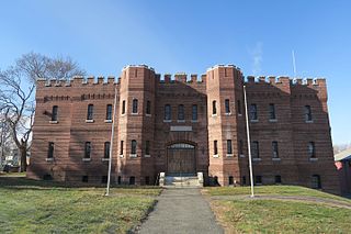
The Hudson Armory is a former Massachusetts Army National Guard armory and training center located at 35 Washington Street in Hudson, Massachusetts, United States. It is a castle-like, two-story brick masonry building built in 1910 at the intersection of Park Street and Washington Street in Hudson along the Assabet River. It was originally constructed for the Massachusetts Volunteer Militia. It was designed by architects James E. McLaughlin and James Mulcahy. As of June 2021, there are plans to convert the currently vacant armory into a community arts center.

The Hampden County Memorial Bridge is a reinforced-concrete arch bridge that spans the Connecticut River between Springfield, Massachusetts and West Springfield, Massachusetts, constructed in 1922. The bridge is owned by Massachusetts Highway Department and is located on Massachusetts Route 147. It spans 209 feet (64 m) and rises 29.71 feet (9.06 m) above the river.
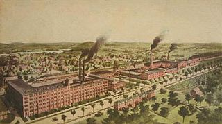
The Firestone–Apsley Rubber Company was a tire company and factory located in Hudson, Massachusetts, United States. It succeeded the rubber clothing companies Apsley Rubber Company and Goodyear Gossamer Company. It operated in its various guises from 1885 to the 1930s. Today the Firestone–Apsley factory building is owned by Hudson Lock, LLC, which produces keys, locks, and related goods.

The Colonel Adelbert Mossman House is a historic house built between 1895 and 1903 located at 76 Park Street in Hudson, Massachusetts, United States. It is a 2+1⁄2-story wood-frame structure with asymmetrical massing typical of Queen Anne Victorian architecture. It has elaborate exterior and interior detailing. The house is listed on the National Register of Historic Places.
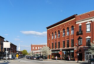
Hudson is a town in Middlesex County, Massachusetts, United States, with a total population of 20,092 as of the 2020 census. Before its incorporation as a town in 1866, Hudson was a neighborhood and unincorporated village of Marlborough, Massachusetts, and was known as Feltonville. From approximately 1850 until the last shoe factory burned down in 1968, Hudson was a mill town specializing in the production of shoes and related products. At one point, the town had 17 shoe factories, many of them powered by the Assabet River, which runs through town. The many factories in Hudson attracted immigrants from Canada and Europe. Today most residents are of either Portuguese or Irish descent, with a smaller percentage being of French, Italian, English, or Scotch-Irish descent. While some manufacturing remains in Hudson, the town is now primarily residential. Hudson is served by the Hudson Public Schools district.

Monroe Street Bridge is bridge over the Passaic River in Passaic and Garfield, New Jersey. The 3-span reinforced concrete elliptical deck arch bridge was built in 1908. It was designed by Colin Wise and built by C.W. Dean and Company. It is 306 feet long and 30.2 feet wide.
The Georgia–Carolina Memorial Bridge was a highway crossing over the Savannah River between the states of Georgia and South Carolina that was in service from 1927 to 1981. The completion of this bridge marked the beginning of the end for Savannah River ferry traffic.
References
- Halprin, Lewis; The Hudson Historical Society (2001) [First published 1999]. Images of America: Hudson. Charleston, SC: Arcadia Publishing. ISBN 0-7385-0073-9.
- Halprin, Lewis; The Hudson Historical Society (2008). Postcard History Series: Hudson. Charleston, SC: Arcadia Publishing. ISBN 978-0-7385-6284-1.