
The Tasman Sea is a marginal sea of the South Pacific Ocean, situated between Australia and New Zealand. It measures about 2,000 kilometres (1,200 mi) across and about 2,800 kilometres (1,700 mi) from north to south. The sea was named after the Dutch explorer Abel Janszoon Tasman, who was the first recorded European to encounter New Zealand and Tasmania. The British explorer Captain James Cook later extensively navigated the Tasman Sea in the 1770s as part of his first voyage of exploration.

The Bay of Islands is an area on the east coast of the Far North District of the North Island of New Zealand. It is one of the most popular fishing, sailing and tourist destinations in the country, and has been renowned internationally for its big-game fishing since American author Zane Grey publicised it in the 1930s. It is 60 km (37 mi) north-west of the city of Whangarei. Cape Reinga, at the northern tip of the country, is about 210 km (130 mi) by road further to the north-west.

Te Anau is a town in the Southland region of the South Island of New Zealand. It is on the eastern shore of Lake Te Anau in Fiordland. Lake Te Anau is the largest lake in the South Island and within New Zealand second only to Lake Taupo. The 2013 census recorded the town's population as 1,911. The town has a wide range of accommodation, with over 4,000 beds available in summer.
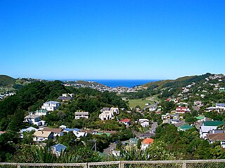
Vogeltown is a hillside suburb of Wellington, New Zealand, on the eastern slopes of Brooklyn and overlooking Newtown. It is sometimes considered part of Mornington. The 2006 census population was 1,890 for Vogeltown.

The Ministry of Education is the public service department of New Zealand charged with overseeing the New Zealand education system.

Te Koko-o-Kupe / Cloudy Bay or simply Cloudy Bay is located at the northeast of New Zealand's South Island, to the south of the Marlborough Sounds and north of Clifford Bay. In August 2014, the name Cloudy Bay, given by Captain Cook in 1770, was officially altered to Te Koko-o-Kupe / Cloudy Bay, with the Māori name recalling the early explorer Kupe scooping up oysters from the bay.
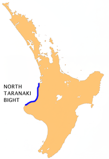
The North Taranaki Bight is a large bay that extends north and east from the north coast of Taranaki in New Zealand's North Island. The name is echoed by the South Taranaki Bight to the south of Cape Egmont.

Maungaturoto is a small town in the Northland Region of New Zealand. The population was 837 in the 2006 Census, an increase of 87 from 2001.

Waiau River is the largest river in the Southland Region of New Zealand. It is the outflow of Lake Te Anau, flowing from it into Lake Manapouri 10 kilometres (6 mi) to the south, and from there flows south for 70 kilometres (43 mi) before reaching the Foveaux Strait 8 kilometres (5 mi) south of Tuatapere. It also takes water from Lake Monowai.

Te Arai is a small community on the east coast of the North Island of New Zealand, near the northern end of the Auckland Region. Mangawhai lies to the north, and Tomarata to the south.

Mokau or Mōkau is a small town on the west coast of New Zealand's North Island, located at the mouth of the Mokau River on the North Taranaki Bight. Mokau is in the Waitomo District and Waikato Region local government areas, just north of the boundary with the New Plymouth District and the Taranaki Region. Prior to 1989, the town was classed as being in Taranaki, and there is still a feeling that the community of interest is most associated with New Plymouth, 90 km to the southwest. State Highway 3 passes through the town on its route from Te Kuiti to Waitara and, eventually, New Plymouth.
Fitzroy is a coastal suburb of New Plymouth, in the western North Island of New Zealand. It is located to the east of the city centre.
The Patea Dam is a high compacted earth fill–type hydroelectric dam in New Zealand, constructed between 1979 and 1984.

Eita is a settlement in Kiribati. It is located on an atoll in South Tarawa.
Terikiai is a settlement in Kiribati. It is located on an atoll; to its west are Nuribenua, Tanaiang, and Te Kapuipui, and to its east are Eita and Utiroa.
Tanaiang is a settlement in Kiribati. It is located on an atoll; to its west is Nuribenua, while Eita and Terikiai lie to the east.
Ruawai is a small township located 30 km south of Dargaville in Northland, New Zealand. The population was 426 in the 2006 Census, a decrease of 30 from 2001.

Barrett Glacier is a glacier draining from the north slopes of the Prince Olav Mountains, about 15 nautical miles (30 km) long, flowing between the Longhorn Spurs and the Gabbro Hills to the Ross Ice Shelf. It was named by the Southern Party of the New Zealand Geological Survey Antarctic Expedition (1963–64) for Peter J. Barrett, a geologist with that party.
Te Pou Hawaiki is a volcano in the Auckland volcanic field in New Zealand. It was a small, low scoria cone south-east of Mount Eden that was quarried away.
Leigh Hunt Glacier is a glacier in Antarctica, 7 nautical miles (13 km) long, flowing north-northwest to enter Brandau Glacier just west of Hare Peak. It was named by the New Zealand Geological Survey Antarctic Expedition (1961–62) for A. Leigh Hunt, founder and first chairman of the New Zealand Antarctic Society.


