
The Alpine region of Switzerland, conventionally referred to as the Swiss Alps, represents a major natural feature of the country and is, along with the Swiss Plateau and the Swiss portion of the Jura Mountains, one of its three main physiographic regions. The Swiss Alps extend over both the Western Alps and the Eastern Alps, encompassing an area sometimes called Central Alps. While the northern ranges from the Bernese Alps to the Appenzell Alps are entirely in Switzerland, the southern ranges from the Mont Blanc massif to the Bernina massif are shared with other countries such as France, Italy, Austria and Liechtenstein.

The Col du Galibier is a mountain pass in the southern region of the French Dauphiné Alps near Grenoble. It is the eighth highest paved road in the Alps, and recurrently the highest point of the Tour de France.

The Zugspitze, at 2,962 m (9,718 ft) above sea level, is the highest peak of the Wetterstein Mountains and the highest mountain in Germany. It lies south of the town of Garmisch-Partenkirchen in Bavaria, and the Austria–Germany border is on its western summit. South of the mountain is the Zugspitzplatt, a high karst plateau with numerous caves. On the flanks of the Zugspitze are two glaciers, the largest in Germany: the Northern Schneeferner with an area of 30.7 hectares and Höllentalferner with an area of 24.7 hectares. Shrinking of the Southern Schneeferner led to the loss of glacier status in 2022.

Kebnekaise is the highest mountain in Sweden. The Kebnekaise massif, which is part of the Scandinavian mountain range, has two main peaks. The glaciated southern peak used to be the highest at 2,120 metres (6,960 ft) above sea level, but has shrunk by 24 meters during the last 50 years, making the northern icefree peak at 2,096.8 metres (6,879 ft) the highest. Kebnekaise lies in Swedish Lapland, about 150 kilometres (93 mi) north of the Arctic Circle and west of Kiruna near the Kungsleden hiking trail between Abisko and Hemavan.

Mount Bogong,, located in the Alpine National Park and part of the Victorian Alps of the Great Dividing Range, is the highest mountain in Victoria, Australia, at 1,986 metres (6,516 ft) above sea level.

Monte Rosa is a mountain massif in the eastern part of the Pennine Alps, on the border between Italy and Switzerland (Valais). The highest peak of the massif, amongst several peaks of over 4.000 m, is the Dufourspitze, the second highest mountain in the Alps and western Europe, after Mont Blanc. The east face of the Monte Rosa towards Italy has a height of about 2.400 meters and is the highest mountain wall of the Alps.

The Hochstaufen is the easternmost mountain of the Chiemgau Alps, Germany. It is located in the north of Bad Reichenhall. The mountain belongs to the Staufen massif and is a popular destination for mountaineering.

The Weissmies 4,017 m (13,179 ft) is a mountain in the Pennine Alps in the canton of Valais in Switzerland near the village of Saas-Fee. It is the easternmost four-thousander of its range.

The Tre Cime di Lavaredo, also called the Drei Zinnen ; pronounced[ˌdʁaɪˈtsɪnən] ), are three distinctive battlement-like peaks, in the Sexten Dolomites of northeastern Italy. They are probably one of the best-known mountain groups in the Alps. The three peaks, from east to west, are:
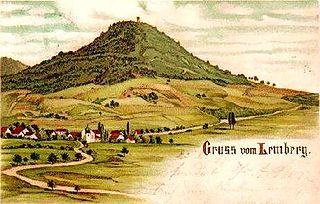
The Lemberg is a mountain located in the Tuttlingen district of Baden-Württemberg, Germany. The mountain is the highest point of the Swabian Jura. It is one of the "Ten Thousanders" —ten 1,000-metre-high summits of the region. On the peak of the mountain is a 30-m-high tower which, reaching above the surrounding trees, offers a beautiful prospect, in clear weather as far as the Alps.

The Monte Rosa Hut is a mountain hut located near Zermatt on the Monte Rosa massif and above the Grenzgletscher sitting on a glacier-free rocky part called Untere Platte at an altitude of 2,883 metres (9,459 ft). It is owned by the Swiss Alpine Club. The hut is the start of the normal route to the summit and other mountains in the area. The first hut was built in 1894–1895 just next to the then still much higher Border Glacier at an altitude of 2,795 metres (9,170 ft). A completely new building was inaugurated in 2009, a hi-tech, energy-wise almost self-sufficient, environmentally friendly mountain hut based on wood with an aluminium shell.

The Wetterstein mountains, colloquially called Wetterstein, is a mountain group in the Northern Limestone Alps within the Eastern Alps. It is a comparatively compact range located between Garmisch-Partenkirchen, Mittenwald, Seefeld in Tirol and Ehrwald along the border between Germany (Bavaria) and Austria (Tyrol). Zugspitze, the highest peak is at the same time the highest mountain in Germany.

Speikboden is a massif in the Central Eastern Alps located between the three valleys Weißenbach, Mühlwald and Ahrntal. Running in a south-easterly direction, it forms the eastern part of an outlier of the western Zillertal Alps. Its highest point, likewise named Speikboden, is 2,517 m. Further well-known peaks in this massif include Seewassernock (2,516 m), Große Nock (2,400 m), Kleine Nock (2,227 m) and Gornerberg (2,475 m).

The Kaiser Mountains are a mountain range in the Northern Limestone Alps and Eastern Alps. Its main ridges – are the Zahmer Kaiser and south of it the Wilder Kaiser. The mountains are situated in the Austrian province of Tyrol between the town of Kufstein and the town of St. Johann in Tirol. The Kaiser Mountains offer some of the loveliest scenery in all the Northern Limestone Alps.

The Hirschberg is a 1,670-metre-high (5,479 ft) mountain in the Bavarian Fore-alps south of Lake Tegernsee.

The Grutten Hut is an Alpine club hut situated at a height of 1620 metres in the Kaisergebirge in Tyrol, Austria. It is owned by the Turner Alps Kränzchen Section of the German Alpine Club. It is the highest mountain hut in the Kaiser Mountains.

The Steinbergstein is a mountain, 2,215 m (AA) (7,267 ft) high, in the Kitzbühel Alps in Austria.
The Brechhorn is a 2,032 m above sea level (AA) high mountain in the Kitzbühel Alps in Austria. It lies between the valleys of the Aschauer Ache and the Windau.
The Pinzgau Ridgeway is a roughly 25 kilometre long ridgeway in the Kitzbühel Alps in the Austrian federal state of Salzburg.

The Hochplattig is a mountain, 2,768 m (AA) high, and the highest summit in the Mieming Chain, a mountain range in the Northern Limestone Alps in the state of Tyrol, Austria.
