Azekah was an ancient town in the Shephela guarding the upper reaches of the Valley of Elah, about 26 km (16 mi) northwest of Hebron.
Jabesh-Gilead, sometimes shortened to Jabesh, was an ancient Israelite town in Gilead, in northwest Jordan. Jabesh is mentioned several times in the Hebrew Bible primarily in connection with King Saul's battles against the Ammonites and Philistines.
Beth-Nimrah or Beth-nimrah, also called Nimrin and Bethennabris, was an ancient city in Transjordan, which features prominently the history of ancient Israel and Judah. Tell Nimrin has been identified by Nelson Glueck as the last of three sites successively occupied by the ancient city.

Bethsaida, also known as Julias or Julia, is a place mentioned in the New Testament. Julias lay in an administrative district known as Gaulonitis. Historians have suggested that the name is also referenced in rabbinic literature under the epithet Ṣaidan.

The Copper Scroll (3Q15) is one of the Dead Sea Scrolls found in Cave 3 near Khirbet Qumran, but differs significantly from the others. Whereas the other scrolls are written on parchment or papyrus, this scroll is written on metal: copper mixed with about 1 percent tin, although no metallic copper remained in the strips; the action of the centuries had been to convert the metal into brittle oxide. The so-called 'scrolls' of copper were, in reality, two separated sections of what was originally a single scroll about 2.4 metres (7.9 ft) in length. Unlike the others, it is not a literary work, but a list of 64 places where various items of gold and silver were buried or hidden. It differs from the other scrolls in its Hebrew, its orthography, palaeography and date.

Perea or Peraea was the term used mainly during the early Roman period for part of ancient Transjordan. It lay broadly east of Judea and Samaria, which were situated on the western side of the Jordan River, and southwest of the Decapolis.

Abila was an ancient city east of the Jordan River in the Plains of Moab, later Peraea, near Livias, about twelve km northeast of the north shore of the Dead Sea. The site is identified with modern Khirbet el-Kafrayn, Jordan and identified on the Madaba Map as an unnamed icon. There is a widely supported theory that in the Hebrew Bible, it is referred to as Abel-Shittim, as well as in the shorter forms Shittim and Ha-Shittim.

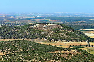
Maresha was an Iron Age city mentioned in the Hebrew Bible, whose remains have been excavated at Tell Sandahanna, an archaeological mound or 'tell' renamed after its identification to Tel Maresha. The ancient Judahite city became Idumaean after the fall of Judah in 586 BCE, and after Alexander's conquest of the region in 332 BCE became Hellenised under the name Marisa or Marissa. The tell is situated in Israel's Shephelah region, i.e. in the foothills of the Judaean Mountains, about 1.5 kilometres (0.93 mi) south of Beit Gubrin.
Tell el-Hammeh is a medium-size archaeological tell in the West Bank, at the southern fringe of the Beit She'an valley. It has been identified with the Canaanite city state of Hammath, mentioned in a late-13th century BCE Egyptian inscription.
Bethharan, Betharan or Beth Haran, also Betharam or Beth-Aram, was a Hebrew Bible city, in the valley-plain east of the Jordan River. In the Book of Joshua, a city called "Betharam" is listed as one of the cities allotted by Moses to Gad, previously belonging to Sihon the Amorite. According to the Book of Numbers, "Betharan" was rebuilt by the tribe of Gad.
Livias was a city in Transjordan in Classical Antiquity. In the writings of Josephus (English translation), the name is presented as Julias.

The Battle of Tell 'Asur, also known as the actions of Tel Asur or the Battle of Turmus 'Aya, took place 8–12 March 1918, after the decisive victory at the Battle of Jerusalem and the Capture of Jericho during the Sinai and Palestine Campaign of World War I. Fighting took place over an area which extended from the Mediterranean to Abu Tellul and Mussalabeh on the edge of the Jordan Valley.
Tell Abu al-Kharaz is an archeological tell in the Irbid Governorate of modern-day Jordan. Tell Abu al-Kharaz was the site of a fortified town during the Bronze and Iron Ages; it is located in the Jordan Valley, 4 kilometers east of the Jordan River.
Amathus (Ancient Greek: Ἀμαθοῦς or τὰ Ἀμαθά; in Eusebius, Ἀμμαθοὺς. Hebrew: עמתו was a fortified city east of the Jordan River, in modern-day Jordan.

Wadi Numeira is a Wadi in Jordan that is known for its deep gorge cut through the sandstone. It gives its name to the Bronze Age ruins located at its mouth with the Dead Sea. The Wadi also sometimes nicknamed Petra with water.
Tell el-Hammam is an archaeological site in the Amman Governorate of Jordan, in the eastern part of the lower Jordan Valley 11.7 kilometers east of the Jordan River and not far from its mouth. It lies 12.6 kilometers northeast of the Dead Sea. The site has substantial remains from the Chalcolithic, Early, Intermediate and Middle Bronze Age, and from Iron Age II. There are different attempts at identifying the site with a biblical city. The Hammam Megalithic Field lies nearby. Other archaeological sites in the vicinity include Tall Nimrin, Tall Bleibel, Tall Mustah, Tall Iktanu, Tall Tahouna, Tall Barakat, Tall Kafrayn, and Tall Rama.

Nancy L. Lapp is an American archaeologist and biblical scholar who has worked on a number of sites in Jordan and Palestine, alongside her husband, Paul Lapp. After her husband's untimely death in 1970, she dedicated herself to publishing all of their excavation reports, an immense task which is still ongoing. Lapp became curator of the Pittsburgh Theological Seminary's Museum of Near Eastern Archaeology in 1970, and in 2000 became Curator Emerita. She also currently serves as a Trustee Emerita of the American Center of Oriental Research (ACOR) in Amman, Jordan, to whom she has donated an expansive collection of photographs documenting her and Paul's travels and archaeological expeditions.

The Plains of Moab are mentioned in three books of the Hebrew Bible as an area in Transjordan, stretching along the Jordan "across from Jericho", and more specifically "from Beth Jeshimoth to Abel Shittim". Here is the last Station of the Exodus and the place from which Moses climbs up on Mount Nebo "to the top of Pisgah", where he dies.
Tell el-Maqlub is an archaeological site in Ajloun Governorate, Jordan. It is dated to the Bronze and Iron Ages.

