
The Buckingham Canal is a 796 kilometres (494.6 mi)-long fresh water navigation canal, that parallels the Coromandel Coast of South India from Kakinada City in the Kakinada district of Andhra Pradesh to Parangipettai near Chidambaram, Cuddalore District of Tamil Nadu, India. The canal connects most of the natural backwaters along the coast to Chennai (Madras) port.

Palar is a river of southern India. It rises in the Nandi Hills in Chikkaballapura district of Karnataka state, and flows 93 kilometres (58 mi) in Karnataka, 33 kilometres (21 mi) in Andhra Pradesh and 222 kilometres (138 mi) in Tamil Nadu before reaching its confluence into the Bay of Bengal at Vayalur about 75 kilometres (47 mi) south of Chennai. It flows as an underground river for a long distance only to emerge near Bethamangala town, from where, gathering water and speed, it flows eastward down the Deccan Plateau. The Towns of Bethamangala, Santhipuram, Kuppam, Mottur, Ramanaickenpet, Vaniyambadi, Ambur, Melpatti, Gudiyatham, Pallikonda, Anpoondi, Melmonavoor, Vellore, Katpadi, Melvisharam, Arcot, Ranipet, Walajapet, Kanchipuram, Walajabad, Chengalpattu, Kalpakkam, and Lattur are located on the banks of the Palar River. Of the seven tributaries, the chief tributary is the Cheyyar River.

Sholavaram aeri, or Sholavaram lake, is located in Ponneri taluk of Thiruvallur district, Tamil Nadu, India. It is one of the rain-fed reservoirs from where water is drawn for supply Chennai city from this lake to Puzhal lake through canals.
Pulhal Lake, or Pulhal aeri, sometimes spelled Puzhal lake and also known as the Red Hills Lake, is located in Red Hills, Chennai, India. It lies in Thiruvallur district of Tamil Nadu state. It is one of the two rain-fed reservoirs that supply water to Chennai City, the other one being the Chembarambakkam Lake and Porur Lake.

Nagarjuna Sagar Dam is a masonry dam across the Krishna River at Nagarjuna Sagar which straddles the border between Palnadu district in Andhra Pradesh and Nalgonda district in Telangana. The dam provides irrigation water to the districts of Krishna, Guntur, Palnadu, Prakasam and parts of West Godavari districts of Andhra Pradesh and also Nalgonda, Suryapet, Khammam, Bhadradri Kothagudem districts of Telangana. It is also a source of electricity generation for the national grid.

The Indian rivers interlinking project is a proposed large-scale civil engineering project that aims to effectively manage water resources in India by linking rivers using a network of reservoirs and canals to enhance irrigation and groundwater recharge and reduce persistent floods in some parts and water shortages in other parts of the country. India accounts for 18% of global population and about 4% of the world's water resources. One of the solutions to solve the country's water woes is to link its rivers and lakes.
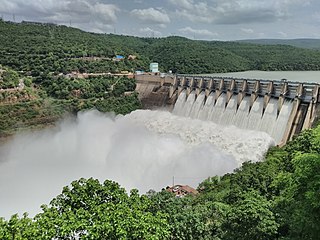
The Srisailam Dam is constructed across the Krishna River in Nandyal district, Andhra Pradesh and Nagarkurnool district, Telangana near Srisailam temple town and is the 2nd largest capacity working hydroelectric station in India.

Chennai is located at 13.04°N 80.17°E on the southeast coast of India and in the northeast corner of Tamil Nadu. It is located on a flat coastal plain known as the Eastern Coastal Plains. The city has an average elevation of 6 metres (20 ft), its highest point being 60 m (200 ft). Chennai is 2,184 kilometres south of Delhi, 1,337 kilometres southeast of Mumbai, and 1,679 kilometers southwest of Kolkata by road.

Interbasin transfer or transbasin diversion are terms used to describe man-made conveyance schemes which move water from one river basin where it is available, to another basin where water is less available or could be utilized better for human development. The purpose of such water resource engineering schemes can be to alleviate water shortages in the receiving basin, to generate electricity, or both. Rarely, as in the case of the Glory River which diverted water from the Tigris to Euphrates River in modern Iraq, interbasin transfers have been undertaken for political purposes. While ancient water supply examples exist, the first modern developments were undertaken in the 19th century in Australia, India and the United States, feeding large cities such as Denver and Los Angeles. Since the 20th century many more similar projects have followed in other countries, including Israel and China, and contributions to the Green Revolution in India and hydropower development in Canada.

The Gundlakamma River is a seasonal waterway that flows through the east-central part of the state of Andhra Pradesh, India. It arises in the Nallamala Hills, an offshoot of the Eastern Ghats. Gundlakamma is the largest of all the rivers that originate from the Nallamalla Hills.

The Polavaram Project is an under construction multi-purpose irrigation project on the Godavari River in the Eluru District and East Godavari District in Andhra Pradesh. The project has been accorded National project status by the Central Government of India. Its reservoir back water spreads up to the Dummugudem Anicut and approx 115 km on Sabari River side. Thus back water spreads into parts of Chhattisgarh and Odisha States. It gives major boost to tourism sector in Godavari Districts as the reservoir covers the famous Papikonda National Park, Polavaram hydro electric project (HEP) and National Waterway 4 are under construction on left side of the river. It is located 40 km to the upstream of Sir Arthur Cotton Barrage in Rajamahendravaram City and 25 km from Rajahmundry Airport.
Kosasthalaiyar River is one of the three rivers that flow in the Chennai metropolitan area, the other two being the Cooum and the Adyar.
Kandeleru Dam is an irrigation project built on the Kandaleru River in Rapur Mandal, Nellore district in the Indian state of Andhra Pradesh. The project is part of the Telugu Ganga project that supplies drinking water to Chennai city from the Srisailam reservoir on Krishna River. Kandaleru reservoir is mainly fed by a link canal from Somasila Dam. The Telugu Ganga project provides irrigation. It is nearly 57 Kilometers from the District Head Quarters.
Velugodu Reservoir is a balancing reservoir and located across the Galeru river, a tributary of Kundu River in Penner River basin, at Velugodu town in Nandyal district of Andhra Pradesh. This reservoir is part of Telugu Ganga project and mainly fed by gravity canal from back waters of Srisailam Dam through Pothireddypadu head / flow regulator located across the feeder canal. Velugodu Reservoir has gross storage capacity of 16.95Tmcft at 265 m MSL full reservoir level.

Kurnool Cuddappah Canal popularly known as K.C. Canal is an irrigation canal located in Kurnool and Kadapa districts in Andhra Pradesh, India.
The coastal city of Chennai has a metropolitan population of 10.6 million as per 2019 census. As the city lacks a perennial water source, catering the water requirements of the population has remained an arduous task. On 18 June 2019, the city's reservoirs ran dry, leaving the city in severe crisis.
The Sri Sathya Sai Central Trust (SSSCT), is a registered public charitable trust founded in 1972 by Sri Sathya Sai Baba. Its humanitarian work includes drinking water projects, healthcare and education.
Poondi Reservoir or Sathyamoorthy reservoir is the reservoir across Kotralai River in Tiruvallur district of Tamil Nadu state in India. It acts as the important water source for Chennai city which is 60 km away.
Thervoy Kandigai reservoir is the fifth major reservoir built to satisfy drinking water needs of Chennai city. The reservoir was constructed by combining Thervoy Kandigai and Kannankottai lakes in Thiruvallur district. It was commissioned by Amit Shah, Internal Affairs minister of India, on 21 November 2020. Water levels in the reservoir reached its full capacity on 11 March 2021 for the first time.
Jogulamba Barrage is a proposed barrage across Krishna River with full pond level (FPL) 274m. It would be located at Veltoor village, Peddamandadi mandal, Wanaparthy district, Telangana, India. This barrage is proposed to divert 3 TMC of water via lift to Yedula Reservoir being built as part of Palamuru-Rangareddy Lift Irrigation Scheme. This would also provide water for Dindi Lift Irrigation Project and Mahatma Gandhi Kalwakurthy Lift Irrigation Scheme.

