
Banyuwangi Regency is a regency of East Java province in Indonesia. This regency also known as the sun rise of Java because it is located at the easternmost end of Java Island. The town of Banyuwangi serves as a port for ferry services between Java and Bali. The regency is surrounded by mountains and forests to the west; by sea to the east and south - is separated by the Strait of Bali from Bali. With an area of 5,782.5 km2, this regency is by far the largest on the island of Java. The regency is a tourist destination, and subject to ongoing development as an international tourist destination with relevant infrastructure. Banyuwangi regency has been declared a taman bumi, or national geological park (Geopark) in 2018.
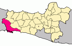
Cilacap Regency is a regency in the southwestern part of Central Java province in Indonesia. Its capital is the town of Cilacap.

Nusa Kambangan is an island located in Indonesia, separated by a narrow strait from the south coast of Java. The closest port is Cilacap in Central Java province. It is known as the place where the fabled wijayakusuma, which translates as the 'flower of victory' in the highest literary register of the Javanese language, grows. The wijayakusuma can be used to bring a person back from the dead, and the princes of the Sultanate of Mataram and later the Surakarta Sunanate sent to the island for the blooms in order to become kings. Thus the island is also known as pulau bunga-bungaan, the 'island of many flowers'. There is a forest reserve on the island. One of the main cultural events is Sedekah Laut, which is held by the Surakarta Sunanate every Satu Suro in the Javanese calendar. Since the Dutch colonial period, there have been a number of supermax prisons on the island, some of which are still operational and run by the Ministry of Law and Human Rights.

Bantul is a regency located in the Special Region of Yogyakarta, Indonesia. It is located on the island of Java. The regency's population was 911,503 at the 2010 Census, but has risen to 985,770 at the 2020 Census and to 1,013,170 at the official estimates for mid 2022 - comprising 504,133 males and 509,037 females. Like many regencies on the island of Java, it is densely populated with roughly 1,999 people per square kilometre in 2022, although this is largely because the north of the regency partly surrounds the city of Yogyakarta and contains many suburban communities, notably in the densely-populated districts of Banguntapan, Sewon and Kasihan.

Pantai Remis is a coastal town in Manjung District, Perak, Malaysia. It is situated in between Simpang and Sitiawan.

The Penang National Park spans 1,213ha of land and sea and is used by scientists, researchers, and nature lovers to explore its natural treasures.
Berau Regency is one of the seven regencies in East Kalimantan province in Indonesia. The capital is the town of Tanjung Redeb. It has an area of 36,962.37 km2 and had a population of 179,079 at the 2010 census and 248,035 at the 2020 census; the official estimate as at mid 2022 was 272,887.

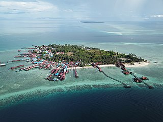
Tirto Samudro beach or Bandengan Beach is located 7 kilometres (4.3 mi) north of downtown Jepara, Central Java, Indonesia.

Pangandaran Regency is a Regency in West Java province, Indonesia, formed on 25 October 2012 out of the former southern portion of Ciamis Regency. The population of this area as of the 2010 Census was 383,848, and was 423,670 at the 2020 Census; the official estimate as of mid-2023 was 431,464. The administrative capital is the town of Parigi.

Bandros or Bandung Tour Bus is a tour bus which operates in Bandung, West Java, Indonesia. It is used by tourists in Bandung City. The bus was unveiled by the Mayor of Bandung, Ridwan Kamil, on New Year's Eve 2014, and on February 18, 2018 it was announced that a tour bus will serve the city's. A local tour leader will accompany tourists on the bus. Bandros is managed by two parties: the Department of Transportation in Bandung and Mang Dudung which forms part of Corporate Social Responsibility. Buses have a capacity of 22 people. There are six buses operated by the Corporate Social Responsibility division, and 12 buses operated by the Regional Revenue and Expenditures Budget which is managed by the BLUD UPT Angkutan Department of Transportation in Bandung.
Brayut is a village designated as a "tourist village" located in Ngaglik district of Sleman Regency in Yogyakarta Special Region, in the Republic of Indonesia.

Kampoeng Rawa is a tourist attraction located within the green belt around Lake Rawa Pening of Ambarawa in Central Java, Indonesia. Opened in August 2012, it is owned and operated by twelve groups of farmers and fishermen who were funded by the Artha Prima Credit Union. It is intended to improve the welfare of local farmers and fishermen while promoting an understanding of the lake's ecology. Facilities include a floating restaurant, pendopo, crafts centre, fishing area, and docks. During holidays the site may be visited by several thousand people. It has been challenged for its lack of permission to build in the green belt and the possible ecological impact.
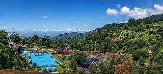
Baturraden is a district in the Banyumas Regency on the slope of Mount Slamet, Central Java, Indonesia. It features panoramic views, waterfalls, a mini-train, paddleboats, a water slide, and a pool. Its name is derived from a legend about star-crossed lovers, a manservant (Batur) and a noblewoman (Raden).

Pancuran Tujuh is a hot spring located on the slopes of Mount Slamet in Baturraden District, Banyumas, Central Java. Discovered, according to local legend, by a Muslim missionary known as Mbah Atas Angin, the hot spring and its sulfuric waters are considered to have healing properties.

Benteng Pendem is an abandoned Dutch fortress in Cilacap Regency, Central Java, which has become the region's main tourist attraction. Built between 1861 and 1879, the fortress originally served to defend the important port of Cilacap, though after a series of changes in ownership it fell into disrepair in the 1960s. In 1987 it was opened to the public.

Karang Bolong Beach is a white-sand beach on the island of Nusa Kambangan in Cilacap Regency, Central Java. Located on the eastern end of the island inside a nature reserve, the beach is situated near an old Dutch fortress, also known as Karang Bolong.

Tanjung Lesung Beach is a beach in Pandeglang Regency, Banten, western tip of Java. It is 160 kilometres (99 mi) from the capital city of Indonesia, Jakarta, and can be reached by car or public bus in about a 3-4-hour drive. It is known as a beach resort with sea views, having a 15-kilometre (9.3 mi) white sand coastline and also marine life where visitors can enjoy snorkeling, diving as well as fishing. The area has been declared as a "cultural heritage" since the location is near Ujung Kulon National Park, Mount Krakatau and Umang Island.
The Madiun River is a river in East Java, Indonesia, about 500 km to the east of the capital Jakarta. It is the largest tributary of the Solo River. Its name indicates that it passes through the major city of Madiun, East Java, Indonesia. This river starts as several smaller tributaries converging near the city of Ponorogo, in particular the Kali Slahung, Kali Keyang, and Kali Sungkur. It eventually converges with the Solo River near the city of Ngawi.

Poedjono Pranyoto was an Indonesian military officer and politician who served as the governor of Lampung from 1988 until 1997 and the deputy speaker of the People's Consultative Assembly from 1997 until 1999.


