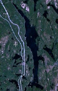
Lake Temagami, formerly spelled as Lake Timagami, is a lake in Nipissing District in northeastern Ontario, Canada, situated approximately 80 km north of North Bay. The lake's name comes from Te-mee-ay-gaming, which means "deep water by the shore" in the Ojibwa language.
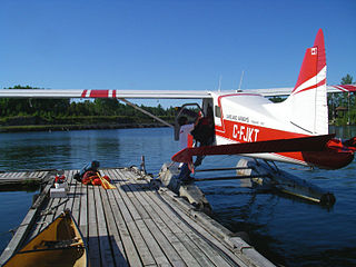
Temagami Water Aerodrome,, is located 2 nautical miles southwest of Temagami, Ontario, Canada.

Temagami/Mine Landing Water Aerodrome,, is located 11.5 nautical miles southwest of Temagami, Ontario, Canada on the east-central shore of Lake Temagami. It lies at the end of the Lake Temagami Access Road, a 17 km (11 mi) long gravel road extending off Highway 11 south of Temagami.
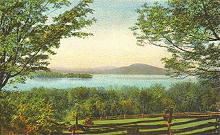
Rangeley Lake is located in Franklin County, Maine in the United States. It is fed by several streams. Its waters flow out from the lake's northwestern end into the short Rangeley River, then into Mooselookmeguntic Lake, and ultimately into the Androscoggin River, Merrymeeting Bay, the lower Kennebec River, the Gulf of Maine and the Atlantic Ocean.
Cassels Lake is a lake located within the Municipality of Temagami, in the Nipissing District, Ontario, Canada. It contains numerous portages, campsites and is one of three lakes on the eastern edge of the White Bear Forest.

James is an incorporated township in the Canadian province of Ontario, located in Timiskaming District. The primary community within the township is Elk Lake, which is located at the junction of Ontario Highway 65 and Ontario Highway 560.

Mary River is located on Baffin Island about 936 km (582 mi) northwest of Iqaluit, the capital of Nunavut, and about 176 km (109 mi) southwest of Pond Inlet. It is home to iron ore deposits discovered in 1962 by Murray Edmund Watts and Ron Sheardown and is being developed by the Baffinland Iron Mines Corporation.
There is a small airstrip, Mary River Aerodrome, located near the river.
Rib Lake is a long and narrow lake in the Town of Latchford and in the Municipality of Temagami in Northeastern Ontario, Canada, located about 9 kilometres (6 mi) southeast of the centre of the community of Latchford and 9 kilometres (6 mi) northeast of the community of Temagami North. The lake is in the Ottawa River drainage basin and is the main access for canoeists en route to Rib Mountain.

Kamaniskeg Lake is a lake in the municipalities of Hastings Highlands, Hastings County, and Madawaska Valley, Renfrew County, in Southern Ontario, Canada. It is part of the Ottawa River drainage basin and is located in the Madawaska River Valley, with nearby communities of Barry's Bay and Combermere. The lake is known for its simple beauty, with a mixture of forest, and rock and sand beaches.

The Milne Townsite, commonly referred to as Milnes, is an abandoned community in Strathy Township, municipality of Temagami, Nipissing District in northeastern Ontario, Canada, located on the north shore of Link Lake, just south of the Milne-Sherman Road, and about 2 km (1.2 mi) north of the town of Temagami. It covered about 3.5% of the town of Temagami and had 40 residents.
The Sherman volcano is a possible prehistoric volcano in the municipality of Temagami in Northeastern Ontario, Canada. Geological evidence indicates that it was located west of the abandoned Sherman Mine and lies in the Archean Temagami Greenstone Belt.
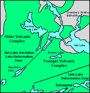
Strathy Township is a square-shaped geographic township comprising a portion of the municipality of Temagami in Northeastern Ontario, Canada. It is used for geographic purposes, such as land surveying and natural resource explorations. At least four other geographic townships surround Strathy Township, namely Best Township, Cassels Township, Strathcona Township and Chambers Township.

Caribou Lake is a lake in the Ottawa River drainage basin in Strathy Township of Temagami, Nipissing District in Northeastern Ontario, Canada. The municipality centre of Temagami is located on the north-northwestern shore of the lake.
Priest Mine is an abandoned surface and underground mine in Northeastern Ontario, Canada. It is located about 19 km (12 mi) northwest of the hamlet of Marten River on an island in north-central Cross Lake. Dating back to the early 1900s, it is one of the oldest mines in the municipality of Temagami.
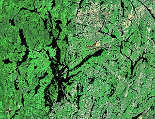
There are more than 200 named lakes located partially or entirely within the Municipality of Temagami, Northeastern Ontario, Canada. They are located in all 25 geographic townships comprising this 1,906.42 km2 (736.07 sq mi) municipality. The largest, by both area and volume, is Lake Temagami. It contains more than 1,200 islands and 1,000 km (620 mi) of shoreline. Other significant lakes include Cross Lake, Gull Lake, Net Lake, Obabika Lake and Rabbit Lake.

Owaissa Lake is a lake in the municipality of Temagami, Nipissing District in Northeastern Ontario, Canada. It is in geographic Best Township and is part of the Saint Lawrence River drainage basin.


