Tereitannano

Last updated

Coordinates: 3°51′36″N159°21′53″W / 3.86000°N 159.36472°W / 3.86000; -159.36472

Geographic coordinate system Coordinate system

A geographic coordinate system is a coordinate system that enables every location on Earth to be specified by a set of numbers, letters or symbols. The coordinates are often chosen such that one of the numbers represents a vertical position and two or three of the numbers represent a horizontal position; alternatively, a geographic position may be expressed in a combined three-dimensional Cartesian vector. A common choice of coordinates is latitude, longitude and elevation. To specify a location on a plane requires a map projection.

Tabuaeran Kiribati.jpg

Tereitannano is a settlement located on Tabuaeran atoll, Kiribati. [1] Tenenebo is to the north; with Aramari to the south.

Tabuaeran atoll in Kiribati

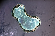
Tabuaeran or Tahanea, known in English as Fanning Atoll, is an atoll that is part of the Line Islands of the central Pacific Ocean and part of Kiribati. The land area is 33.73 square kilometres, and the population in 2010 was 1,960. The maximum elevation is about 3 m (10 ft) above high tide.

Atoll Ring-shaped coral reef, generally formed over a subsiding oceanic volcano, with a central lagoon and perhaps islands around the rim

An atoll, sometimes called a coral atoll, is a ring-shaped coral reef including a coral rim that encircles a lagoon partially or completely. There may be coral islands or cays on the rim. The coral of the atoll often sits atop the rim of an extinct seamount or volcano which has eroded or subsided partially beneath the water. The lagoon forms over the volcanic crater or caldera while the higher rim remains above water or at shallow depths that permit the coral to grow and form the reefs. For the atoll to persist, continued erosion or subsidence must be at a rate slow enough to permit reef growth upwards and outwards to replace the lost height.

Kiribati island nation in the central Pacific Ocean

Kiribati, officially the Republic of Kiribati, is a sovereign state in Micronesia in the central Pacific Ocean. The permanent population is just over 110,000 (2015), more than half of whom live on Tarawa Atoll. The state comprises 32 atolls and reef islands and one raised coral island, Banaba. They have a total land area of 800 square kilometres (310 sq mi) and are dispersed over 3.5 million square kilometres. Their spread straddles both the equator and the 180th meridian, although the International Date Line goes round Kiribati and swings far to the east, almost reaching the 150°W meridian. This brings the Line Islands into the same day as the Kiribati Islands. Kiribati's easternmost islands, the southern Line Islands, south of Hawaii, have the most advanced time on Earth: UTC+14 hours.

In the 2010 census 168 people were recorded as living in Tereitannano. [1]

Related Research Articles

Line Islands chain of eleven atolls and low coral islands in the central Pacific Ocean

The Line Islands, Teraina Islands or Equatorial Islands, is a chain of atolls and coral islands. Kingman Reef is a largely submerged and Filippo Reef is shown on some maps, although its existence is doubted. The islands were formed by volcanic activity and are located in the central Pacific Ocean, south of the Hawaiian Islands. The 11 islands stretch for 2,350 kilometres in a northwest–southeast direction, making it one of the longest island chains of the world. Eight of the islands form part of Kiribati, while the remaining three are United States territories grouped with the United States Minor Outlying Islands. Only Kiritimati and Tabuaeran atolls and Teraina Island have a permanent population.

Anote Tong I-Kiribati politician with Chinese heritage

Anote Tong is an I-Kiribati politician with Chinese heritage who served as President of Kiribati from 2003 to 2016. He won the election in July 2003 with a slim plurality of votes cast (47.4%) against his older brother, Dr. Harry Tong (43.5%) and the private lawyer Banuera Berina (9.1%). The elections were contested by the opposition, due to allegations of electoral fraud but the High Court of Tarawa had confirmed that there was no fraud. He was re-elected on 17 October 2007 for a second term (64%). In 2012, Tong was reelected for a third term, although with a significantly smaller percentage than in the previous two elections.

Torrenueva is a municipality located in the province of Ciudad Real, Castile-La Mancha, Spain. It has a population of 2,988 (2014).

Napari human settlement in Kiribati

Napari or Napali is a settlement located at the north end of Tabuaeran atoll, Kiribati. In the 2002 census 194 people were recorded as living in Napali. While Napali was not listed in the 2010 census as having any residents, the city of Tereitaki on the southern Napali was reported as having 346 inhabitants.

Tereitaki human settlement in Kiribati

Tereitaki is a settlement located towards the north end of Tabuaeran atoll, Kiribati. Napari is the northernmost settlement; with Betania to the south.

Betania, Kiribati human settlement in Kiribati

Betania is a settlement located on Tabuaeran atoll, Kiribati.

Paelau human settlement in Kiribati

Paelau is a settlement located on Tabuaeran atoll, Kiribati. It is located on the western side of the atoll, south of a passage into the lagoon, with Betania to the north and Aontenaa to the south.

Aontenaa human settlement in Kiribati

Aontenaa is a settlement located on Tabuaeran atoll, Kiribati. Paelau is to the north; with Tenenebo to the south.

Tenenebo human settlement in Kiribati

Tenenebo is a settlement located on Tabuaeran atoll, Kiribati. Aontenaa is to the north; with Tereitannano to the south.

Aramari human settlement in Kiribati

Aramari is a settlement located on Tabuaeran atoll, Kiribati. Tereitannano is to the north; with Mwanuku or Eten to the south.

Mwanuku human settlement in Kiribati

Mwanuku or Manuku or Eten is a settlement located on Tabuaeran atoll, Kiribati. Eten is the most south village on the atoll. Aramari is the village to north.

Greenland Township is a civil township in Barnes County, North Dakota, USA. As of the 2000 census, its population was 52.

Lunda, Ohio Unincorporated community in Ohio, United States

Lunda is an unincorporated community in Libery Township, Union County, Ohio, United States. It is located at 40°21′53″N83°30′42″W, at the intersection of Lunda Road and Perkins Road, about three miles southeast of West Mansfield.

Sandy Bay, Devon

Sandy Bay is a secluded bay with a sand beach, about 1.6 kilometres (0.99 mi) long, in Exmouth, Devon, England. It is a sandy beach with rock pools at one end, backed by high cliffs. It is part of a long strip of sand which is connected to the beach at Exmouth at low tide. Nearby are the Orcombe rocks, which is a famous spot for fossils.

Millwood, Gloucester County is an unincorporated community in Gloucester County, in the U. S. state of Virginia.

Tekiau Aretaateta is a member of the Kiribati House of Assembly for the constituency of Tabuaeran.

Harper is an unincorporated community in Ross County, in the U.S. state of Ohio.

References

  1. 1 2 "21. Tabuaeran" (PDF). Office of Te Beretitent - Republic of Kiribati Island Report Series. 2012. Retrieved 28 April 2015.