Related Research Articles

Powder River County is a county in the U.S. state of Montana. As of the 2020 census, the population was 1,694. Its county seat is Broadus.

White Settlement is a city in Tarrant County, Texas, United States, and a northwestern suburb of Fort Worth. The population was 17,851 in 2019.

The Canada–United States border is the longest international border in the world. The terrestrial boundary is 8,891 km (5,525 mi) long. The land border has two sections: Canada's border with the contiguous United States to its south, and with the U.S. state of Alaska to its west. The bi-national International Boundary Commission deals with matters relating to marking and maintaining the boundary, and the International Joint Commission deals with issues concerning boundary waters. The agencies currently responsible for facilitating legal passage through the international boundary are the Canada Border Services Agency (CBSA) and U.S. Customs and Border Protection (CBP).

US Highway 141 (US 141) is a north–south United States Numbered Highway in the states of Wisconsin and Michigan. The highway runs north-northwesterly from an interchange with Interstate 43 (I-43) in Bellevue, Wisconsin, near Green Bay, to a junction with US 41/M-28 near Covington, Michigan. In between, it follows city streets in Green Bay and has a concurrent section with US 41 in Wisconsin. North of Green Bay, US 141 is either a freeway or an expressway into rural northern Wisconsin before downgrading to an undivided highway. In Michigan, US 141 is an undivided highway that runs through rural woodlands. The highway has two segments in each state; after running through Wisconsin for about 103 miles (166 km), it crosses into Michigan for approximately another eight miles (13 km). After that, it crosses back into Wisconsin for about 14+1⁄2 miles (23 km) before crossing the state line one last time. The northernmost Michigan section is about 43+1⁄2 miles (70 km), making the overall length about 169 miles (272 km).

The Fore River is a short horn-shaped estuary, approximately 5.7 miles (9.2 km) long, separating Portland and South Portland in Maine in the United States. Many of the port facilities of the Portland harbor are along the estuary, which is formed just southwest of Portland by the confluence of several creeks. The estuary was initially known as Levett's River, so named by the first English settler of the Casco Bay region, Capt. Christopher Levett. But shortly afterwards, the estuary came to have the name by which it is known today.
Red Bay is a fishing village in Labrador, notable as one of the most precious underwater archaeological sites in the Americas. Between 1530 and the early 17th century, it was a major Basque whaling area. Several whaling ships, both large galleons and small chalupas, sank there, and their discovery led to the designation of Red Bay in 2013 as a UNESCO World Heritage Site.

Route 138 is a major highway in the Canadian province of Quebec, following the entire north shore of the Saint Lawrence River past Montreal to the temporary eastern terminus in Kegashka on the Gulf of Saint Lawrence. The western terminus is in Elgin, at the border with New York State south-west of Montreal. Part of this highway is known as the Chemin du Roy, or King's Highway, which is one of the oldest highways in Canada.
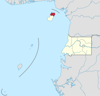
Bioko Norte is the second-most populated of the eight provinces of Equatorial Guinea, after the Wele-Nzas province. Both the provincial capital, Rebola, and the national capital, Malabo are located here. Heavily forested with little urban development, the southern central part includes part of the Parque Nacional del Pico Basilé, a 330 square kilometres (130 sq mi) national park which was established in 2000. On the northeast coast is a hotel run by the Sofitel chain.
Tanintharyi or Taninthayi is a small town in Taninthayi Township, Myeik District, in the Tanintharyi Region of south-western Myanmar. It is the administrative seat for the township. The town is located on the Great Tenasserim River which eventually enters the sea at Myeik. The town is located at the confluence of this river and a tributary known as the "Little Tenasserim River" which runs south.

Chapman River is a river in the Mid West region of Western Australia.

A total of ten special routes of U.S. Route 71 exist, and another ten previously existed.
Tabaw is a small village in Homalin Township, Hkamti District, in the Sagaing Region of northwestern Burma. Tabaw lies on the Chindwin River, to the north of Natset.
Talaunggyaung is a river village in Homalin Township, Hkamti District, in the Sagaing Region of northwestern Burma. It lies near the border with India.
Thayagon is a village in Homalin Township, Hkamti District, in the Sagaing Region of northwestern Burma. It lies on the Chindwin River.
The Néra River is a river of New Caledonia. It has a catchment area of 546 square kilometres, forming one of the largest river systems on the west coast. It empties into the eastern side of Gouaro Bay.
Moindou Bay or Baie Moundou is a bay in southwestern New Caledonia. It lies 50 km north of Saint Vincent Bay.Teremba Bay lies to the east and the town of Moindou just to the north.
Gouaro Bay or Baie Gouaro is a bay in southwestern New Caledonia. It lies northwest of Moindou Bay. The settlements of Gouaro and La Roche Percee lie on the bay and the Néra River empties into it on its eastern side.
Nampur is a village in Nashik District of Maharashtra, India. As per census of 2011 by Govt of India It is situated near Satana also called as Baglan Taluka, the headquarters for Baglan Taluka, at the distance of 21 km. Nampur is known in the states of Maharashtra, Karnataka and Gujarat for its cattle market. It is near to Gujarat and is a major transportation hub. It is 35 kilometers from the city of Malegaon and 25 from Taharabad on the road (SH-16) to Gujarat. The first MLA elected from Baglan Taluka was from Tembhe which is just 7 km from Nampur. In the 2001 census, the village of Nampur had 12,458 inhabitants, with 6,386 males (51.3%) and 6,072 females (48.7%), for a gender ratio of 951 females per thousand males
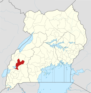
Kitagwenda District is a district in Western Uganda. The district is named after Kitagwenda County, which is coterminous with the district.
References
- ↑ Google (29 May 2023). "Teremba Bay" (Map). Google Maps . Google. Retrieved 29 May 2023.
| | This New Caledonian location article is a stub. You can help Wikipedia by expanding it. |