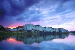
The Upper Missouri River Breaks National Monument is a national monument protecting the Missouri Breaks of central Montana, United States. It is managed by the Bureau of Land Management. It is a series of badland areas characterized by rock outcroppings, steep bluffs and grassy plains, a topography referred to as "The Breaks" by locals. Created by Proclamation by President William J. Clinton on January 17, 2001, it encompasses 495,502 acres (200,523 ha), most of which were already managed by the U.S. government. The adjacent Missouri River was designated a Wild and Scenic River in 1976 and forms a western boundary while the Charles M. Russell National Wildlife Refuge is to the east. The Breaks country was a model for many of the paintings done by painter Charles M. Russell.

The El Paso Mountains Wilderness was created in 1994 and now has a total of 23,780 acres (96.2 km2). All of the wilderness is in the northern Mojave Desert in eastern Kern County, California and is managed by the Bureau of Land Management. It is located south of Ridgecrest, California.

The King Range is a mountain range of the Outer Northern California Coast Ranges System, located entirely within Humboldt County on the North Coast of California.

National Conservation Lands, formally known as the National Landscape Conservation System, is a 35-million-acre (140,000 km2) collection of lands in 873 federally recognized areas considered to be the crown jewels of the American West. These lands represent 10% of the 258 million acres (1,040,000 km2) managed by the Bureau of Land Management (BLM). The BLM is the largest federal public land manager and is responsible for over 40% of all the federal public land in the nation. The other major federal public land managers include the US Forest Service (USFS), National Park Service (NPS), and the US Fish and Wildlife Service (USFWS).

A wilderness study area (WSA) contains undeveloped United States federal land retaining its primeval character and influence, without permanent improvements or human habitation, and managed to preserve its natural conditions. WSAs are not included in the National Wilderness Preservation System until the United States Congress passes wilderness legislation.

The Bisti/De-Na-Zin Wilderness is a 45,000-acre (18,000 ha) wilderness area located in San Juan County in the U.S. state of New Mexico. Established in 1984, the Wilderness is a desolate area of steeply eroded badlands managed by the Bureau of Land Management, with the exception of three parcels of private Navajo land within its boundaries. The John D. Dingell, Jr. Conservation, Management, and Recreation Act, signed March 12, 2019, expanded the Bisti/De-Na-Zin Wilderness by approximately 2,250 acres.

The Oregon Badlands Wilderness is a 29,301-acre (11,858 ha) wilderness area located east of Bend in Deschutes and Crook counties in the U.S. state of Oregon. The wilderness is managed by the Bureau of Land Management as part of the National Landscape Conservation System and was created by the Omnibus Public Land Management Act of 2009, which was signed into law by President Barack Obama on 30 March 2009.
The El Malpais National Conservation Area is a federally protected conservation area in the U.S. state of New Mexico. The El Malpais National Conservation area was established in 1987 and is managed by the Bureau of Land Management as part of the National Landscape Conservation System. The adjoining El Malpais National Monument was established at the same time and is managed by the National Park Service.
The Garnet Range, highest point Old Baldy Mountain, elevation 7,511 feet (2,289 m), is a mountain range northeast of Drummond, Montana in Powell County, Montana.
The Gravelly Range, highest peak Black Butte, el. 10,542 feet (3,213 m), is a mountain range southwest of Cameron, Montana in Madison County, Montana.
Sleeping Giant Wilderness Study Area is a non-motorized recreation area located on the west side of the Missouri River and Holter Lake located about 30 miles (48 km) north of Helena, Montana. Designated as a wilderness study area in 1981, the Sleeping Giant Wilderness Study Area contains approximately 6,666 acres (2,698 ha) of nearly roadless land, about half of which is forested. A portion of the Lewis and Clark National Historic Trail is contained inside the study area.
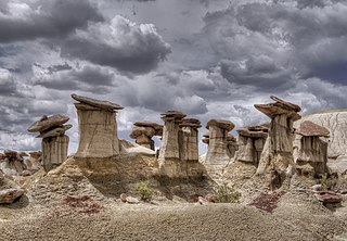
Ah-Shi-Sle-Pah Wilderness is located in San Juan County, New Mexico, between Chaco Canyon and the De-Na-Zin Wilderness. The wilderness has multicolored badlands, sandstone hoodoos, petrified wood and dinosaur bones, similar to those found in the nearby Bisti Badlands and De-Na-Zin Wilderness.

Aden Lava Flow Wilderness is one of many Wildernesses operated by the Bureau of Land Management (BLM) in New Mexico. It is 25,287 acres (10,233 ha) in size. The John D. Dingell, Jr. Conservation, Management, and Recreation Act, signed March 12, 2019, designates the Wilderness as a component of the National Wilderness Preservation System, protecting approximately 27,673 acres.
The Little City of Rocks Wilderness Study Area is a Bureau of Land Management wilderness study area in Gooding County, Idaho between the towns of Gooding and Fairfield. The WSA can be accessed via a short dirt road from Idaho State Highway 46. It covers 5,875 acres (2,378 ha) and has a state inholding that covers 640 acres (260 ha). The WSA is located on the Bennett Hills and features a collection of rock features called hoodoos, which cover about 34% of the WSA. The Little City of Rocks WSA is contiguous with three other WSAs in the Bennett Hills: Black Canyon, Gooding City of Rocks East, and Gooding City of Rocks West. Portions of the WSA's borders are formed by dirt roads, which also separates it from the Black Canyon WSA.
The Black Canyon Wilderness Study Area is a Bureau of Land Management wilderness study area in Gooding County, Idaho between the towns of Gooding and Fairfield. It covers 10,371 acres (4,197 ha) and has a state inholding that covers 640 acres (260 ha). The WSA is located on the Bennett Hills and features a small collection of rock features called hoodoos. The Black Canyon WSA is contiguous with three other WSAs in the Bennett Hills: Little City of Rocks, Gooding City of Rocks East, and Gooding City of Rocks West. Portions of the WSA's borders are formed by dirt roads, which also separates it from the Little City of Rocks and Gooding City of Rocks East WSAs.
The Gooding City of Rocks East Wilderness Study Area is a Bureau of Land Management wilderness study area that covers 14,743 acres (5,966 ha) in Gooding County, Idaho between the towns of Gooding and Fairfield. The WSA is located on the Bennett Hills and features a collection of rock features called hoodoos, which rise to more than 100 feet (30 m). The Gooding City of Rocks East WSA is contiguous with three other WSAs in the Bennett Hills: Black Canyon, Gooding City of Rocks West, and Little City of Rocks. Portions of the WSA's borders are formed by dirt roads, which also separates it from the Gooding City of Rocks West and Black Canyon WSAs.
The Gooding City of Rocks West Wilderness Study Area is a Bureau of Land Management wilderness study area that covers 6,287 acres (2,544 ha) in Gooding County, Idaho between the towns of Gooding and Fairfield. The WSA is located in the Bennett Hills and features a collection of rock features called hoodoos, which rise to more than 100 feet (30 m). The Gooding City of Rocks West WSA is contiguous with three other WSAs in the Bennett Hills: Black Canyon, Gooding City of Rocks East, and Little City of Rocks. Portions of the WSA's borders are formed by dirt roads, which also separates it from the Gooding City of Rocks West and Black Canyon WSAs.

Saddle Peak Hills Wilderness is the smallest designated wilderness area created by the California Desert Protection Act of 1994.


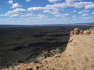
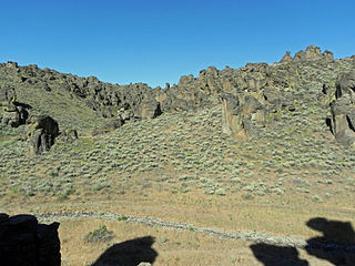
 A typical ridgeline in the Terry Badlands WSA.
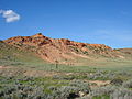
 View of Terry from the WSA.
