Perry County is a county in the U.S. state of Pennsylvania. As of the 2010 United States Census, the population was 45,969. The county seat is New Bloomfield. The county was created on March 22, 1820, and was named for Oliver Hazard Perry, a hero of the War of 1812, who had recently died. It was originally part of Cumberland County and was created in part because residents did not want to travel over the mountain to Carlisle, and thus the temporary county seat became Landisburg
Huntingdon County is a county located in the center of the U.S. state of Pennsylvania. As of the 2010 census, the population was 45,913. Its county seat is Huntingdon. The county was created on September 20, 1787, mainly from the north part of Bedford County, plus an addition of territory on the east from Cumberland County.

Blair County is a county located in the U.S. Commonwealth of Pennsylvania. As of the 2020 census, the population was 122,822. Its county seat is Hollidaysburg. The county was created on February 26, 1846, from parts of Huntingdon and Bedford counties.

Scouting in Pennsylvania has a long and rich tradition, from 1908 to the present day, serving thousands of youth in programs that suit the environment in which they live.
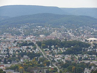
Altoona is a city in Blair County, Pennsylvania. It is the principal city of the Altoona Metropolitan Statistical Area (MSA). The population was 43,963 at the time of the 2020 Census, making it the eighteenth most populous city in Pennsylvania. The Altoona MSA includes all of Blair County and was recorded as having a population of 122,822 at the 2020 Census, around 100,000 of whom live within a 5-mile (8.0 km) radius of the Altoona city center according to U.S. Census ZIP Code population data. This includes the adjacent boroughs of Hollidaysburg and Duncansville, adjacent townships of Logan, Allegheny, Blair, Frankstown, Antis, and Tyrone, as well as nearby boroughs of Bellwood and Newry.

Frankstown Township is a township in Blair County, Pennsylvania, United States. It is part of the Altoona Metropolitan Statistical Area. The population was 7,399 at the 2020 census. The township was named after Stephen Franks, a pioneer citizen.

Williamsburg in Morrisons Cove, is a borough in Blair County, Pennsylvania, United States. The population was 1,254 at the 2010 census. It is part of the Altoona, PA Metropolitan Statistical Area.
Huntingdon is a borough in Huntingdon County, Pennsylvania, United States. It is located along the Juniata River, approximately 32 miles (51 km) east of Altoona and 92 miles (148 km) west of Harrisburg. With a population of 7,093 at the 2010 census, it is the largest population center near Raystown Lake, a winding, 28-mile-long (45 km) flood-control reservoir managed by the U.S. Army Corps of Engineers.

The Juniata River is a tributary of the Susquehanna River, approximately 104 miles (167 km) long, in central Pennsylvania. The river is considered scenic along much of its route, having a broad and shallow course passing through several mountain ridges and steeply lined water gaps. It formed an early 18th-century frontier region in Pennsylvania and was the site of French-allied Native American attacks against English colonial settlements during the French and Indian War.

Horseshoe Curve is a three-track railroad curve on Norfolk Southern Railway's Pittsburgh Line in Blair County, Pennsylvania. The curve is about 2,375 feet (700 m) long and 1,300 feet (400 m) in diameter. Completed in 1854 by the Pennsylvania Railroad as a way to reduce the westbound grade to the summit of the Allegheny Mountains, it replaced the time-consuming Allegheny Portage Railroad, the only other route across the mountains for large vehicles. The Curve was later owned and used by three Pennsylvania Railroad successors, Penn Central, Conrail, and Norfolk Southern.

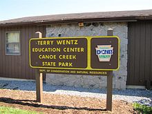
Canoe Creek State Park is a 911.91-acre (369.04 ha) Pennsylvania state park in Frankstown Township in Blair County, Pennsylvania. It is 12 miles east of Altoona, the nearest city. Canoe Lake, at 155 acres (63 ha), is the focus of recreation at the park and is open for fishing year-round. Canoe Creek State Park is a half mile off U.S. Route 22 near the small town of Canoe Creek. The park was opened to the public in 1979 and was developed as part of an expansion effort in the 1970s to improve the state park system in Pennsylvania.
The Lower Trail is a 16.5-mile (26.6 km) rail trail that follows the Juniata River in West-Central Pennsylvania from Flowing Springs in Blair County to Alfarata in Huntingdon County. The Lower Trail is owned and maintained by Rails to Trails of Central Pennsylvania, a 501c3 organization. The trail follows the path of the former Pennsylvania Railroad Petersburg Branch along the Frankstown Branch of the Juniata River. It is open free of charge to the public, though donations are accepted at all trail heads. The portion of the Lower Trail from Alfarata to Williamsburg is part of the Pennsylvania Mid State Trail and Great Eastern Trail. In 2009, the trail was designated as a National Recreation Trail by the United States Department of the Interior.

The Frankstown Branch Juniata River is a 46.0-mile-long (74.0 km) tributary of the Juniata River in Blair and Huntingdon counties, Pennsylvania, in the United States.

The Raystown Branch Juniata River is the largest and longest tributary of the Juniata River in south-central Pennsylvania in the United States.

Pennsylvania Route 36 is a 151.12 mi (243.2 km) long state highway located in the U.S. state of Pennsylvania. The southern terminus is at PA 26 near the Hopewell Township community of Yellow Creek. The northern terminus is at PA 27 and PA 227 in Pleasantville.
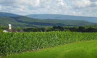
Morrisons Cove, is an eroded anticlinal valley in Blair and Bedford counties of central Pennsylvania, United States, extending from Evitts Mountain near New Enterprise, north to the Frankstown Branch Juniata River at Williamsburg. The width of the valley varies from 10 to 15 miles between Tussey Mountain on the east to the chain of Dunning, Loop and Lock Mountains on the west. Almost entirely enclosed by these mountains, the only openings in the cove are at Loysburg Gap in the south, McKee Gap in the west, and at Williamsburg to the north. The floor of the valley is mostly level, with many large fertile farm fields. The southern end of the valley drains to the Raystown Branch Juniata River via Yellow Creek through Loysburg Gap, and the northern end drains to the Frankstown Branch, via Clover Creek.

The Railroaders Memorial Museum is a railroad museum in Altoona, Pennsylvania. The museum focuses on the history of railroad workers and railroad communities in central Pennsylvania, particularly Altoona, the Altoona Works, and the greater Pittsburgh area. Since 1998, the museum has been located in the Master Mechanics Building, built by the Pennsylvania Railroad in 1882. The museum also operates a separate museum, visitor center, and observation area at the Horseshoe Curve.

The Altoona and Beech Creek Railroad was a 3 ft narrow gauge railroad in Pennsylvania that operated during the late ninteeth and early twentieth centuries. It carried passenger traffic from the vicinity of Altoona to Wopsononock and coal and timber from Wopsononock and Dougherty to Altoona. Originally constructed to facilitate the development of coal mines and resorts atop the Allegheny Plateau, it became involved in a complicated and ultimately unsuccessful scheme to break the Pennsylvania Railroad's control over the Clearfield Coalfield. Never very profitable, it went through several reorganizations, the last in 1913. Conversion to 4 ft 8+1⁄2 instandard gauge in 1916 did not improve the situation, and the railroad was abandoned in 1919.
The Bloody Run Canoe Classic (BRCC) is a community canoe and kayak race along the Raystown Branch of the Juniata River in Everett, Pennsylvania. Historically, this event has comprised a five and nine mile race, with multiple race classes that include "both recreational and competition-class boats".
The Pennsylvania State Game Lands Number 166 are Pennsylvania State Game Lands in Blair and Huntingdon Counties in Pennsylvania in the United States providing hunting, trapping, bird watching, and other activities.