
Mills County is a county located in Central Texas, United States. It was created on March 15, 1887, from parts of four existing counties—Brown, Comanche, Hamilton, and Lampasas—and named after John T. Mills. The 2020 census reported a population of 4,456. The county seat is Goldthwaite. A long-time resident of the county quipped that residing here is the closest a person could get to living in Mayberry.

Mason County is a rural county located on the Edwards Plateau in the U.S. state of Texas. At the 2020 census, its population was 3,953. Its county seat is Mason. The county is named for Fort Mason, which was located in the county.
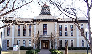
Bastrop County is located in the U.S. state of Texas. It is in Central Texas and its county seat is Bastrop.

The Ark-La-Tex is a socio-economic tri-state region where the Southern U.S. states of Arkansas, Louisiana, and Texas join together. The region contains portions of Northwest Louisiana, Northeast Texas, and South Arkansas as well as the extreme southeastern tip of Oklahoma, in McCurtain County, partly centered upon the Red River, which flows along the Texas–Oklahoma state line into Southwestern Arkansas and Northwest Louisiana.

Texas' 1st congressional district in the United States House of Representatives serves the northeastern portion of the state of Texas. As of 2022, the 1st district contained 775,992 people. It consists largely of three small East Texas metropolitan areas—Texarkana, Texas, Longview–Marshall, and Tyler. With a Cook Partisan Voting Index rating of R+26, it is the most Republican district in Texas. It has been represented by Republican Nathaniel Moran since 2023.

Westbury is a neighborhood in the Brays Oaks district of Southwest Houston, Texas, United States. It is located east of Bob White Road, north of U.S. Highway 90 Alternate, and west of South Post Oak Road, adjacent to the Fondren Southwest and Meyerland neighborhoods, just west of the southwest corner of the 610 Loop.

The Transit Authority of River City (TARC) is the major public transportation provider for Louisville, Kentucky and parts of southern Indiana, including the suburbs of Clark County and Floyd County. TARC is publicly funded and absorbed private mass-transit companies in Louisville, the largest of which was the Louisville Transit Company. In 2023, the system had a ridership of 6,655,200.

Southampton Place, also known as Southampton, is a neighborhood located in Houston, Texas. The Southampton Civic Club Inc. is the homeowners' association.

Old Braeswood is a neighborhood of single family homes in Houston, Texas, United States. It is generally bounded by South Main, North Braeswood, Kirby Drive, and Holcombe. The Texas Medical Center, Rice University, Rice Village, and the NRG Center complex are all within a one-mile radius. Nearby neighborhoods include Southgate, West University Place and Braeswood Place.
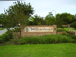
Willowbend is a neighborhood in near Southwest Houston, Texas.

Braeburn is a community of subdivisions in southwest Houston, Texas along Brays Bayou west of Hillcroft Avenue and south of the Sharpstown community. The first of these middle class subdivisions was developed after World War II at a time when the Richmond Farm-to-Market Road provided the route into the city, rather than U.S. Highway 59. Development continued into the 1970s. The Braeburn Country Club is located in the center of the community. Subdivisions found here include Robindell, Braeburn Terrace, Braeburn Glen, Larkwood, Braeburn Valley, Bonham Acres, Braes Timbers and—the acreage lot subdivision—Brae Acres. The area also includes commercial and multi-family developments. Braeburn is notable for its large number of mid-century modern homes, tree lined streets, and location close to the Galleria, the Texas Medical Center, Reliant Park, the major freeways- 59, 610 and the Beltway. The communities of Braeburn have in recent years formed the Braeburn Superneighborhood, a coalition of Home Owner Associations, in order to interact more effectively with the City of Houston and other area agencies. The Brays Bayou hike and bike trail runs through the community, providing easy access to over 15 miles of excellent trails.

The government of Louisville, Kentucky, headquartered at Louisville City Hall in Downtown Louisville, is organized under Chapter 67C of the Kentucky Revised Statutes as a First-Class city in the state of Kentucky. Created after the merger of the governments of Louisville, Kentucky and Jefferson County, Kentucky, the city/county government is organized under a mayor-council system. The Mayor is elected to four-year terms and is responsible for the administration of city government. The Louisville Metro Council is a unicameral body consisting of 26 members, each elected from a geographic district, normally for four-year terms. The Mayor is limited to a two consecutive term limit, while members of the Louisville Metro Council are not term limited.

Bastrop State Park is a state park in Bastrop County, Texas, United States. The park was established in 1933 and consists of stands of loblolly pines mixed with post oak and junipers.

The Austin–Round Rock–San Marcos metropolitan statistical area, or Greater Austin, is a five-county metropolitan area in the U.S. state of Texas, as defined by the Office of Management and Budget. The metropolitan area is situated in Central Texas on the western edge of the American South and on the eastern edge of the American Southwest, and borders Greater San Antonio to the south.

Cedar Creek is an census-designated place (CDP) in Bastrop County, Texas, United States. It is located about 11 miles (18 km) west of the city of Bastrop. The community takes its name from Cedar Creek, a tributary of the Colorado River that is close to the area. Cedar Creek is home to McKinney Roughs Nature Park, which features natural landscapes and an archaeological site.

The Bastrop County Complex fire was a conflagration that engulfed parts of Bastrop County, Texas, in September and October 2011. The wildfire was the costliest and most destructive wildfire in Texas history and among the costliest in U.S. history, destroying 1,696 structures and causing an estimated $350 million in insured property damage. An exceptional drought, accompanied by record-high temperatures, affected Texas for much of 2011. Vegetation consequently became severely parched throughout the state, and over the year an unprecedented amount of land in the state was burned by numerous wildfires. In early September 2011, the presence of Tropical Storm Lee to the east produced strong northerly winds over the state, exacerbating the preexisting dry weather to produce critical fire conditions. On the afternoon of September 4, 2011, three separate fires ignited in the wildland–urban interface east of Bastrop, Texas, after strong winds caused by the nearby tropical storm snapped trees onto power lines. Within 48 hours, the fires merged into one blaze that quickly consumed parts of Bastrop State Park and parts of the Lost Pines Forest, as well as homes in nearby subdivisions. Most of the conflagration's spread and destruction occurred within a week of ignition, as the forward advance of the wildfire mostly stopped after September 7. The wildfire was largely contained in September, though the firebreak was briefly breached in early October. On October 10, the Bastrop County Complex was declared controlled, and the fire was declared extinguished on October 29 after 55 days of burning within the fire perimeter.

Travis County has had two locations named Montopolis. The first was during the Republic of Texas period north of the Colorado River. The second is today's Montopolis neighborhood in Austin, Texas south of the river. Located southeast of the city's urban core, today's neighborhood is in ZIP code 78741. Montopolis is bounded by Lake Lady Bird on the north, by Grove Street and the Pleasant Valley neighborhood on the west, to the south by Texas State Highway 71, and by U.S. Route 183 on the east. The southeast corner abuts Austin-Bergstrom International Airport. Montopolis is in City Council District 3.
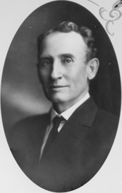
William Harding Mayes was Lieutenant Governor of the U.S. state of Texas (1913–1914), a newspaperman who published the Brownwood Bulletin and founder of the University of Texas journalism school.

The following is a timeline of the history of the city of San Antonio, Texas, United States.