Related Research Articles

The Public Land Survey System (PLSS) is the surveying method developed and used in the United States to plat, or divide, real property for sale and settling. Also known as the Rectangular Survey System, it was created by the Land Ordinance of 1785 to survey land ceded to the United States by the Treaty of Paris in 1783, following the end of the American Revolution. Beginning with the Seven Ranges in present-day Ohio, the PLSS has been used as the primary survey method in the United States. Following the passage of the Northwest Ordinance in 1787, the Surveyor General of the Northwest Territory platted lands in the Northwest Territory. The Surveyor General was later merged with the United States General Land Office, which later became a part of the U.S. Bureau of Land Management (BLM). Today, the BLM controls the survey, sale, and settling of lands acquired by the United States.
The Dominion Land Survey is the method used to divide most of Western Canada into one-square-mile (2.6 km2) sections for agricultural and other purposes. It is based on the layout of the Public Land Survey System used in the United States, but has several differences. The DLS is the dominant survey method in the Prairie provinces, and it is also used in British Columbia along the Railway Belt, and in the Peace River Block in the northeast of the province.
A civil township is a widely used unit of local government in the United States that is subordinate to a county, most often in the northern and midwestern parts of the country. The term town is used in New England, New York, as well as Wisconsin to refer to the equivalent of the civil township in these states; Minnesota uses "town" officially but often uses it and "township" interchangeably. Specific responsibilities and the degree of autonomy vary in each state. Civil townships are distinct from survey townships, but in states that have both, the boundaries often coincide and may completely geographically subdivide a county. The U.S. Census Bureau classifies civil townships as minor civil divisions. Currently, there are 20 states with civil townships.
A township in some states of the United States is a small geographic area.

The Welsh Tract, also called the Welsh Barony, was a portion of the Province of Pennsylvania, a British colony in North America, settled largely by Welsh-speaking Quakers in the late 17th century. The region is located to the west of Philadelphia. The original settlers, led by John Roberts, negotiated with William Penn in 1684 to constitute the Tract as a separate county whose local government would use the Welsh language. The Barony was never formally created, but the many Welsh settlers gave their communities Welsh names that survive today. A more successful attempt at setting up a Gwladfa occurred two centuries later, in the Chubut Province of Patagonia, Argentina.

The Land Ordinance of 1785 was adopted by the United States Congress of the Confederation on May 20, 1785. It set up a standardized system whereby settlers could purchase title to farmland in the undeveloped west. Congress at the time did not have the power to raise revenue by direct taxation, so land sales provided an important revenue stream. The Ordinance set up a survey system that eventually covered over three-quarters of the area of the continental United States.
A survey township, sometimes called a Congressional township or just township, as used by the United States Public Land Survey System and by Canada's Dominion Land Survey is a nominally-square area of land that is nominally six survey miles on a side. Each 36-square-mile township is divided into 36 sections of one square mile each. The sections can be further subdivided for sale.

The chain is a unit of length equal to 66 feet, used in both the US customary and Imperial unit systems. It is subdivided into 100 links. There are 10 chains in a furlong, and 80 chains in one statute mile. In metric terms, it is 20.1168 m long. By extension, chainage is the distance along a curved or straight survey line from a fixed commencing point, as given by an odometer.
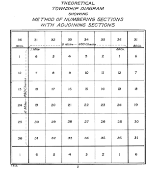
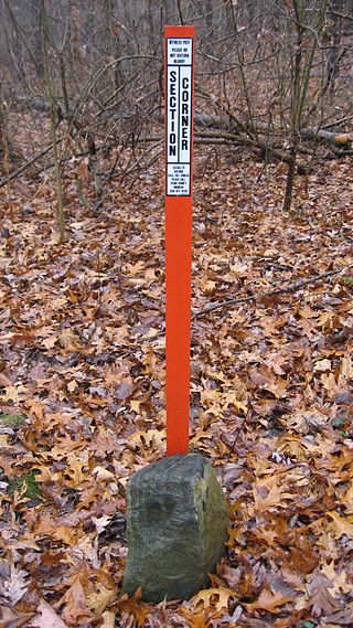
In U.S. land surveying under the Public Land Survey System (PLSS), a section is an area nominally one square mile, containing 640 acres, with 36 sections making up one survey township on a rectangular grid.
Metes and bounds is a system or method of describing land, real property or real estate. The system has been used in England for many centuries and is still used there in the definition of general boundaries. The system is also used in the Canadian province of Ontario, and throughout Canada for the description of electoral districts. By custom, it was applied in the original Thirteen Colonies that became the United States and in many other land jurisdictions based on English common law, including Zimbabwe, South Africa, India and Bangladesh. While still in hand-me-down use, this system has been largely overtaken in the past few centuries by newer systems such as rectangular and lot and block.
There are a number of Spanish units of measurement of length or area that are virtually obsolete due to metrication. They include the vara, the cordel, the league and the labor. The units of area used to express the area of land are still encountered in some transactions in land today.
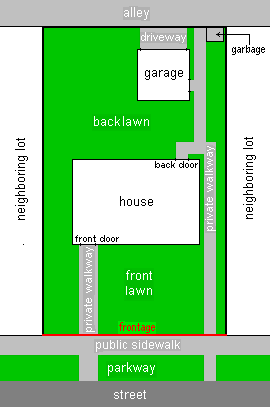
In real estate, a Land lot or plot of land is a tract or parcel of land owned or meant to be owned by some owner(s). A plot is essentially considered a parcel of real property in some countries or immovable property in other countries. Possible owners of a plot can be one or more persons or another legal entity, such as a company, corporation, organization, government, or trust. A common form of ownership of a plot is called fee simple in some countries.

The Spanish and Mexican governments made many concessions and land grants in Alta California and Baja California from 1775 to 1846. The Spanish Concessions of land were made to retired soldiers as an inducement for them to settle in the frontier. These Concessions reverted to the Spanish crown upon the death of the recipient.
Ayers v. Watson, 113 U.S. 594 (1885), was an action of trespass to try title of certain land in Bell County, Texas, originally brought in the district court of that county by Watson, the defendant in error, against the plaintiffs in error and one Anderson.
Rancho Sespe was a 8,881-acre (35.94 km2) Mexican land grant in present-day Ventura County, California given in 1833 by Governor José Figueroa to Carlos Antonio Carrillo. The grant encompassed the Santa Clara River Valley between Piru Creek on the east and Santa Paula Creek on the west, and was bounded to the north and south by the mountains, and included present day Fillmore.

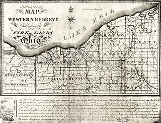
The Seven Ranges was a land tract in eastern Ohio that was the first tract to be surveyed in what became the Public Land Survey System. The tract is 42 miles (68 km) across the northern edge, 91 miles (146 km) on the western edge, with the south and east sides along the Ohio River. It consists of all of Monroe, Harrison, Belmont and Jefferson, and portions of Carroll, Columbiana, Tuscarawas, Guernsey, Noble, and Washington County.
Seven Ranges Terminus is a stone surveying marker near Magnolia, Ohio that marks the completion of the first step in opening the lands northwest of the Ohio River to sale and settlement by Americans. This survey marked the first application of the rectangular plan for subdividing land.

The Congress Lands East of Scioto River was a land tract in southern Ohio that was established by the Congress late in the 18th century. It is located south of the United States Military District and Refugee Tract, west of the Old Seven Ranges, east of the Virginia Military District and north of the Ohio River, French Grant, and the Ohio Company of Associates.

The Twelve Mile Square Reservation, also called the Twelve Mile Square Reserve, was a tract of land in Ohio ceded by Indians to the United States of America in the Treaty of Greenville in 1795. This particular area of land immediately surrounding Fort Miami was considered to be of strategic importance by the United States government representatives. It was subsequently surveyed in a manner different from surrounding land, and lots sold, or granted, to settlers.

Butts and bounds, shortened form for "abuttals and boundaries" of a property, are the boundary lines delineated between plots of land, usually those which define the end of an estate, as used in legal deeds, titles, etc. These are usually descriptive features in the property, such as trees, outcroppings of stone, or riverine brooks, etc., and are signified in the legal deed for purposes of identification.
References
- ↑ Ford, Joanna (2012-08-04). "Land Grid: Understanding the Texas Land Survey System". Land Grid. Retrieved 2017-06-12.
- ↑ Gold, Kenneth G. (2009). Selected Texas Statutes and Boundary Decisions for Land Surveyors, Land Title Agents and Title Attorneys (Second ed.). Austin: Texas Society of Professional Land Surveyors. p. 347.
- ↑ Carter, D. B. (2016). "Texas Land Survey System". Digital Data Services, Inc. Retrieved 2017-06-12.
- ↑ "How much is a league and a labor of land?". To Everything a Season. Retrieved 2017-06-12.
- ↑ "Frequently Asked Questions". Star of the Republic Museum. Washington, Texas: Blinn College. Archived from the original on 2018-01-21. Retrieved 2017-06-12.