Related Research Articles

Portland is the most populous city in the U.S. state of Maine and the seat of Cumberland County. Portland's population was 68,408 in April 2020. The Greater Portland metropolitan area has a population of approximately 550,000 people. Historically tied to commercial shipping, the marine economy, and light industry, Portland's economy in the 21st century relies mostly on the service sector. The Port of Portland is the second-largest tonnage seaport in the New England area as of 2019.

Cape Elizabeth is a town in Cumberland County, Maine, United States. The town is part of the Portland–South Portland–Biddeford, Maine, metropolitan statistical area. As of the 2020 census, Cape Elizabeth had a population of 9,535.

Falmouth is a town in Cumberland County, Maine, United States. The population was 12,444 at the 2020 census. It is part of the Portland–South Portland–Biddeford, Maine metropolitan statistical area.

Brunswick is a town in Cumberland County, Maine, United States. Brunswick is included in the Lewiston-Auburn, Maine metropolitan New England city and town area. The population was 21,756 at the 2020 United States Census. Part of the Portland-South Portland-Biddeford metropolitan area, Brunswick is home to Bowdoin College, the Bowdoin International Music Festival, the Bowdoin College Museum of Art, the Peary–MacMillan Arctic Museum, and the Maine State Music Theatre. It was formerly home to the U.S. Naval Air Station Brunswick, which was permanently closed on May 31, 2011, and has since been partially released to redevelopment as "Brunswick Landing".

Casco Bay is an inlet of the Gulf of Maine on the southern coast of Maine, New England, United States. Its easternmost approach is Cape Small and its westernmost approach is Two Lights in Cape Elizabeth. The city of Portland sits along its southern edge and the Port of Portland lies within.
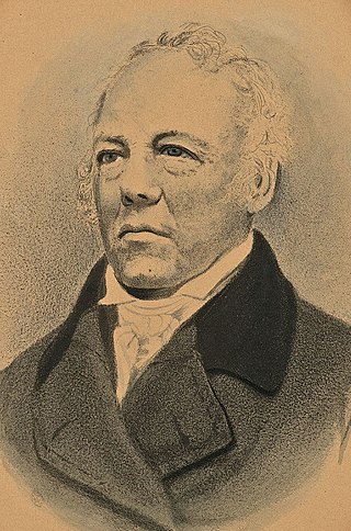
Albion Keith Parris was the 5th Governor of Maine, a United States representative from the District of Maine, Massachusetts, a United States senator from Maine, a United States district judge of the United States District Court for the District of Maine, an associate justice of the Maine Supreme Judicial Court and the 2nd Comptroller of the Currency for the United States Department of the Treasury.
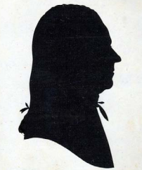
Peleg Wadsworth was an American Patriot officer during the American Revolutionary War and a Congressman from Massachusetts representing the District of Maine. He was also grandfather of noted American poet Henry Wadsworth Longfellow.

Fort Gorges is a former United States military fort built on Hog Island Ledge in Casco Bay, Maine, United States. Built from 1858 to 1864, no battles were fought there and no troops were stationed there. Advancing military technology, including iron clad ships and long range guns, rendered the fort obsolete before it could be used. The fort is now a park, accessible only by boat. It was added to the National Register of Historic Places in 1973.
Munjoy Hill is a neighborhood and prominent geographical feature of Portland, Maine. It is located east of downtown and south of East Deering, the neighborhood via Tukey's Bridge. In the nineteenth and twentieth centuries, the neighborhood had a large Irish and Italian American population.

The History of Portland, Maine, begins when Native Americans originally called the Portland peninsula Məkíhkanək meaning "At the fish hook" in Penobscot and Machigonne in Algonquian. The peninsula and surrounding areas was home to members of the Algonquian-speaking Aucocisco branch of the Eastern Abenaki tribe who were forcibly relocated to current day Canada during European settlement.
The West End is a downtown neighborhood in Portland, Maine. It is located on the western side of Portland's peninsula primarily on Bramhall Hill and is noted for its architecture and history. The neighborhood is home to many late 19th- and early 20th-century homes and, in 2010, it was called "one of the best preserved Victorian neighborhoods in the country". The Western Promenade, a park laid out in 1836, overlooks the forests and small settlements of Southwestern Maine, along with the distant White Mountains. Other historic structures include 68 High Street, The Gothic House, Brown House, Butler House, Ingraham House, Morrill Mansion and the Minott House.

The 6th Maine Infantry Regiment was an infantry regiment that served in the Union Army during the American Civil War.
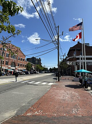
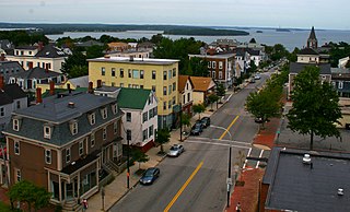
Commercial Street is a downtown street in the Old Port of Portland, Maine, United States. It is part of U.S. Route 1A. It became the Old Port's waterfront in the early 20th century, replacing Fore Street, after land was reclaimed from the waters of Casco Bay and the Fore River.
The Raid on Salmon Falls involved Joseph-François Hertel de la Fresnière, along with Norridgewock Abnaki chief Wahowa, and possibly Maliseet Abnaki war chief Assacumbuit, leading his troops as well as the Wabanaki Confederacy in New Brunswick to capture and destroy an English settlement of Salmon Falls during King William's War.
The Battle of Falmouth involved Joseph-François Hertel de la Fresnière and Baron de St Castin leading troops as well as the Wabanaki Confederacy in New Brunswick to capture and destroy Fort Loyal and the English settlement on the Falmouth neck, then part of the Massachusetts Bay Colony. The commander of the fort was Captain Sylvanus Davis. After two days of siege, the settlement's fort, called Fort Loyal, surrendered. The community's buildings were burned, including the wooden stockade fort, and its people were either killed or taken prisoner. The fall of Fort Loyal (Casco) led to the near depopulation of Europeans in Maine. Native forces were then able to attack the New Hampshire frontier without reprisal.
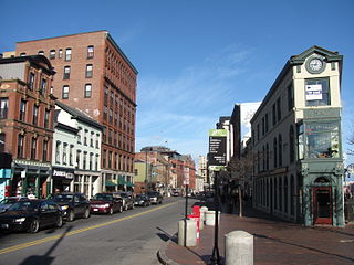
Congress Street is the main street in Portland, Maine. Around 5.77 miles (9.29 km) long, it stretches from County Road, Portland's southwestern border with Westbrook, through a number of neighborhoods, before ending overlooking the Eastern Promenade on Munjoy Hill. In March 2009, the Portland City Council designated much of the inner portion of Congress Street a historic district. The western section of the street includes the city's Arts District.
The following is a timeline of the history of the city of Portland, Maine, USA.
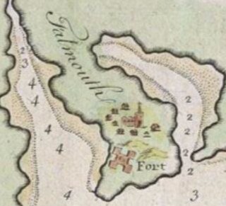
Fort Loyal was a British settler refuge and colonial outpost built in 1678 at Falmouth in Casco Bay. It was destroyed in 1690 by Abenaki and French forces at the Battle of Fort Loyal. The fort was rebuilt in 1742 and renamed Falmouth Fort before King George's War and rearmed again in 1755 for the French and Indian War. The fort was rebuilt a final time in 1775 for the American Revolution.
The 240th Coast Artillery Regiment was a Coast Artillery Corps regiment in the Maine National Guard. It garrisoned the Harbor Defenses of Portland, Maine 1924–1944.

Fort Casco was an English fort built in present-day Falmouth, Maine in 1698. It was the easternmost English fortification in New England and served as the boundary between English settlement and Wabanaki territory.
References
- 1 2 The Origins of the Street Names of the City of Portland, Maine as of 1995 – Norm and Althea Green, Portland Public Library (1995)