St. John's is the capital and largest city of the Canadian province of Newfoundland and Labrador, located on the eastern tip of the Avalon Peninsula on the island of Newfoundland.
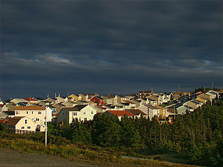
Paradise is a town on the Avalon Peninsula in the province of Newfoundland and Labrador, Canada. Paradise is the third largest settlement in the province and is part of the St. John's metropolitan area, the 20th largest metropolitan area in Canada. The town borders the City of St. John's, the City of Mount Pearl, the Town of Portugal Cove-St. Philip's, and the town of Conception Bay South. According to the 2016 census the population of Paradise is 21,389, after recording a 21% increase in population over five years.

Cape Spear is a headland located on the Avalon Peninsula of Newfoundland near St. John's in the Canadian province of Newfoundland and Labrador. At a longitude of 52°37' W, it is the easternmost point in Canada and North America, excluding Greenland.
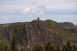
Signal Hill is a hill which overlooks the city of St. John's, Newfoundland and Labrador, Canada. Mostly a National Historic Site, adjacent to is the largely encaved museum of Johnson Geo Centre and its associated park. The highest point, Ladies' Lookout, above Cabot Tower, is 167 metres (548 ft) high. The community of The Battery lies on the slope of the hill overlooking the Harbour. On 12 December 1901, the first transatlantic wireless transmission was received by Guglielmo Marconi, to its abandoned fever hospital.

Ferryland is a provincial electoral district for the House of Assembly of Newfoundland and Labrador, Canada. As of 2011, there are 8,571 eligible voters living within the district.

Harbour Grace is a town in Conception Bay on the Avalon Peninsula in the province of Newfoundland and Labrador, Canada. With roots dating back to the 16th century, it is one of the oldest towns in North America.

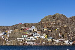
Quidi Vidi is a neighbourhood in St. John's, Newfoundland and Labrador. The village is adjacent to Quidi Vidi Lake. Quidi Vidi's harbour is known as "The Gut". Located in Quidi Vidi is the Quidi Vidi Battery Provincial Historic Site. The village is home to several small businesses.
Goulds is a designated place in the Canadian province of Newfoundland and Labrador. It is a rural neighbourhood within the City of St. John's southeast of the city centre.
The Burin Peninsula is a peninsula located on the south coast of the island of Newfoundland in the province of Newfoundland and Labrador. Marystown is the largest population centre on the peninsula.
Fortune Bay is a fairly large natural bay located in the Gulf of St. Lawrence on the south coast of Newfoundland, Canada. The Bay is bounded by Point Crewe on the Burin Peninsula and Pass Island at the entrance to Hermitage Bay to the northwest for a distance of 56 kilometers. The bay extends in a northeast direction for 105 kilometers ending at Terrenceville.

Fort Amherst is a neighbourhood in St. John's, Newfoundland and Labrador. It is located at 47°33′48.96″N52°40′49.60″W, on the southern side of the Narrows, the entrance to St. John's harbour. Apart from some family dwellings, Fort Amherst consists of a man-made harbour, a lighthouse and the remains of gun emplacements built during World War II to defend against German U-boats. Two QF 4.7-inch B Mark IV* guns remain in place on their mountings.

Georgestown is a Neighbourhood Improvement Area in St. John's, Newfoundland and Labrador a short distance north from downtown of St. John's. This was established in the 1970s as part of an effort by Federal and local government to improve inner cities. Originally what was known as Georgestown village was much smaller and only "extended from Donnelly's Lane to what is now Belvedere Street". The neighbourhood improvement area includes, in addition to the original Georgestown, the former Monkstown and Tubridtown, along with adjoining land, including Circular Road, and Belvedere Street as well as some other parts of the former Belvedere Estate. It is bordered by Military Road, Monkstown Road, Empire Avenue, a small part of Carpasian Road, the east side of Bonaventure Avenue, and Holy Heart and Brother Rice Schools to the west. It was settled, around 1819, as the city's first suburb. The name is an evolution of "George (Winter)'s Town", as it was known in the 19th century.
The neighbourhood of Pleasantville in St. John's, Newfoundland and Labrador is located in the east end of the city, directly north of the downtown. The neighbourhood extends from the north side of Quidi Vidi Lake northward to Newfoundland Drive, and is largely made up of apartment blocks.

The Narrows, is the only passage from the Atlantic Ocean to St. John's Harbour, Newfoundland, bordered north and south by steep rock walls. A skilled captain is required to navigate large ships through the Narrows, known as “threading the eye of the needle”. The channel has a least depth of 11 metres and at its narrowest point near Chain Rock is 61 metres wide. From at least circa 1830, metal rings were set into the rock on either side of the Narrows so that boats could "warp in" and be hauled along to clear the cliffs and dangerous rocks in the water. In 1855, work began to blast away the submerged top of the Merlin Rock to make a safer passage for steam ships.
The timeline of St. John's history shows the significant events in the history of St. John's, Newfoundland and Labrador.

The Newfoundland expedition was a series of fleet manoeuvres and amphibious landings in the coasts of Newfoundland, Labrador and Saint Pierre and Miquelon carried out by the combined French and Spanish fleets during the French Revolutionary Wars. This expedition, composed of seven ships of the line and three frigates under the orders of Rear-Admiral Richery sailed from Cadiz in August 1796 accompanied by a much stronger Spanish squadron, commanded by General Solano, which had the aim of escorting it to the coast of Newfoundland.
Fort Waldegrave was a battery or an emplacement for heavy guns in St. John’s Newfoundland, strategically overlooking the Narrows and St John’s Harbour.

Fort William was a fort in St. John's built in 1698 to protect English interests on Newfoundland, primarily against French opposition. It was the original headquarters of the British garrison in Newfoundland. A second fort, known as Fort George was situated at the east end of the harbour connected by a subterranean passage with Fort William. On the south side of the Narrows, there was a third fortification called the Castle. Garrison headquarters were later moved to Fort Townshend, which was built between 1775-1779.
Division No. 1, Subdivision U is an unorganized subdivision on the Avalon Peninsula in Newfoundland and Labrador, Canada, in Division 1. It contains the unincorporated communities of Admiral's Cove, Bauline East, Bauline South, Burnt Cove, Devils Kitchen, Flat Rock, St. Michaels and Seal Cove.

In mid-January 2020, a complex system of winter storms that crossed North America, bringing heavy snowfall and high winds to Atlantic Canada and the northern United States between 15 and 18 January. At least one person was killed, in California, while at least one went missing, in Newfoundland. The person who went missing in Newfoundland was later found dead. Another two people died in Newfoundland after shoveling snow, although the connection to the storm is unclear. The winter storm caused historic blizzard conditions in many areas, particularly Atlantic Canada.