
The Shire of Burdekin is a local government area located in North Queensland, Australia in the Dry Tropics region. The district is located between Townsville and Bowen in the delta of the Burdekin River. The shire covers an area of 5,044 square kilometres (1,947 sq mi). It has existed as a local government entity since 1888. In the 2021 census, the Shire of Burdekin had a population of 16,692 people.

Batemans Bay is a town in the South Coast region of the state of New South Wales, Australia. Batemans Bay is administered by the Eurobodalla Shire council. The town is situated on the shores of an estuary formed where the Clyde River meets the southern Pacific Ocean.

Parkes is a town in the Central West region of New South Wales, Australia. It is the main settlement in the local government area of Parkes Shire. Parkes had a population of 9,832 at the 2021 census.

Cobar is a town in central western New South Wales, Australia whose economy is based mainly upon base metals and gold mining. The town is 712 km (442 mi) by road northwest of the state capital, Sydney. It is at the crossroads of the Kidman Way and Barrier Highway. The town and the local government area, the Cobar Shire, are on the eastern edge of the outback. At the 2016 census, the town of Cobar had a population of 3,990. The Shire has a population of approximately 4,700 and an area of 44,065 square kilometres (17,014 sq mi).

Nyngan is a town in the centre of New South Wales, Australia, in the Bogan Shire local government area within the Orana Region of central New South Wales. At the 2016 census, Nyngan had a population of 1,988 people. Nyngan is situated on the Bogan River between Narromine and Bourke, on the junction of the Mitchell Highway and Barrier Highway, 656 km (408 mi) south of Charleville and 576 km (358 mi) north-west of Sydney by road. The Barrier Highway starts at Nyngan, and runs west to Cobar and on through Wilcannia and Broken Hill into South Australia.
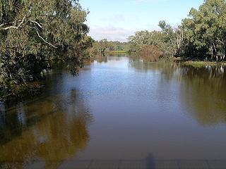
Bogan River, a perennial river that is part of the Macquarie–Barwon catchment within the Murray–Darling basin, is located in the central west and Orana regions of New South Wales, Australia.

The big things of Australia are large structures, some of which are novelty architecture and some sculptures. In Australia, big things have come to be seen as a uniquely Australian phenomenon, although they emerged at the same time as the so-called Roadside Giants of the United States. These structures have become affectionately known landmarks scattered throughout the country. In 2022, there were just over 1075 big things in Australia. There are big things in each state and some territories in continental Australia.

Wyong Shire was a local government area located in the Central Coast region of New South Wales, Australia. The incorporation of the Wyong area dates back to 7 March 1906 when the entire area of the Brisbane Water Police District outside of the Town of Gosford was proclaimed as the Erina Shire. From 1 January 1947, local government in the Central Coast region was reorganised, creating Gosford Shire and Wyong Shire, which comprised Erina Shire north and east of Kulnura, Central Mangrove and Lisarow.

The Division of Parkes is an Australian electoral division in the state of New South Wales.

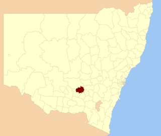
Bogan Shire is a local government area in the Orana region of New South Wales, Australia. The Shire is located adjacent to the Mitchell and Barrier highways and its only significant town is Nyngan.

Bogan Gate is a small village in Parkes Shire of the Central West of New South Wales, Australia. At the 2011 census, Bogan Gate and the surrounding area had a population of 307. Bogan Gate is derived from the local Aboriginal word meaning "the birthplace of a notable headman of the local tribe".
Temora Shire is a local government area in the Riverina region of New South Wales, Australia. It is on Burley Griffin Way. The Shire was created on 1 January 1981 via the amalgamation of Narraburra Shire and the Municipality of Temora.

Thallon is a town and a locality in the Shire of Balonne, Queensland, Australia. In the 2021 census, the locality of Thallon had a population of 231 people.

Girilambone is a small village in western New South Wales, Australia. It is located north of Nyngan and 610 km north-west of Sydney. The name is also applied to the surrounding area, for postal and statistical purposes. At the 2016 census, the population of the village and its surrounding area was only 107, but it had fallen to just 86 in 2021. The village was originally associated with copper mining.

The Nyngan Solar Plant or Farm is one of the largest operating solar plants in Australia. At the time of construction, it was the largest solar plant in the southern hemisphere. It is located 10 km west of Nyngan in western New South Wales. It was built and is operated by AGL Energy.
Wharfdale is a bounded rural locality, and cadastral parish south of Nyngan and west of Tottenham, New South Wales.
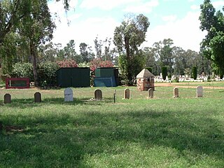
The Chinese Graves and Burner at Nyngan Cemetery is a heritage-listed burial site located at Cemetery Road, Nyngan, in the Orana region of New South Wales, Australia. They were created from 1913 to 1924. The property is owned by NSW Land Registry Services, a privatised agency of the New South Wales Government. The site was added to the New South Wales State Heritage Register on 13 March 2009.
Canonba is a locality in the Orana region of New South Wales, Australia. There was also a village of the same name, which is now a ghost town. It lay on Duck Creek, a tributary of the Bogan River, approximately 30 km north-east of Nyngan. Since 1983, the old village site has been known officially as Old Canonba.

Hermidale is a village in the Orana region of New South Wales, Australia. It is 600km north-west of Sydney and the two closest towns are Nyngan and Cobar. It lies on the Barrier Highway. At the 2021 Census, the population of Hermidale was 127.
Miandetta is a locality in the Bogan Shire, within the Orana region, of New South Wales, Australia. There was once a small settlement, also known as Miandetta. The locality had a population of 23, in 2021.
