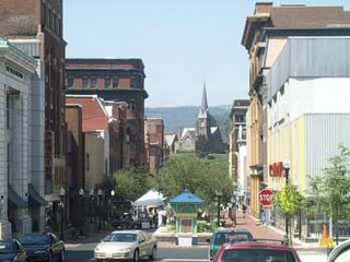
Lonaconing is a town in Allegany County, Maryland, along the Georges Creek Valley. It is part of the Cumberland, MD-WV Metropolitan Statistical Area. The population was 1,214 at the 2010 census.
Georges Creek is a 17.6-mile-long (28.3 km) tributary stream of the North Branch Potomac River in western Maryland. The creek has its headwaters near Frostburg and empties into the North Branch Potomac River at Westernport, all in western Allegany County. Along the Georges Creek Valley, there exists a series of small towns founded in the nineteenth century for miners' homes. The Georges Creek Valley is rich in wide veins of coal, once extracted by deep mines but still mined today through surface mining.
Barnesboro, Pennsylvania was a borough located in Cambria County, Pennsylvania, United States. The area was first settled by Europeans in the early-to-middle 19th century. The presence of the West Branch of the Susquehanna River allowed loggers to move their harvest down stream. Small farms developed, but the town came into existence in 1894 when bituminous coal mining of extensive coal fields in the area became the dominant industry. The town was named for Thomas Barnes of the Barnes and Tucker Coal company, which opened mines in the area. The several mining companies required skilled workers and many came from Great Britain and Eastern Europe. Railroads were built to transport the coal out and the town flourished with the influx of money. Barnesboro existed from 1894 to 2000 when it merged with the adjacent borough of Spangler to create the borough of Northern Cambria. The local public school district is the Northern Cambria School District, whose athletic teams play under the nickname "Colts" and wear black and gold as the school colors.
The Cumberland and Pennsylvania Railroad (C&P) was an American railroad which operated in Western Maryland. Primarily a coal hauler, it was owned by the Consolidation Coal Company, and was purchased by the Western Maryland Railway (WM) in 1944.

WMHS Braddock Campus was a hospital that served the Greater Cumberland, Maryland region in the USA.

Memorial Hospital is a defunct hospital that once served the Greater Cumberland, Maryland region in the USA. It was formerly operated by the Western Maryland Health System. The building is currently owned by the City of Cumberland, Maryland.

Cumberland, MD-WV MSA, or Cumberland Metro for short, is the Metropolitan Statistical Area of Cumberland, Maryland and the surrounding economic region of Allegany County, Maryland and Mineral County, West Virginia, in the United States.

Wills Mountain is a quartzite-capped ridge in the Ridge and Valley physiographic province of the Appalachian Mountains in Pennsylvania and Maryland, United States, extending from near Bedford, Pennsylvania, to near Cumberland, Maryland. It is the northernmost of several mountain ridges included within the Wills Mountain Anticline.
Collier Mountain is mountain in the Ridge and Valley region of the Appalachian Mountains, located in Allegany County, Maryland. The 1,457 feet (444 m) ridge is approximately 5 miles (8.0 km) southeast of Cumberland. It runs 6 miles (9.7 km) northeast from the North Branch Potomac River near its confluence with Patterson Creek to Murley Branch south of Breakneck Hill.

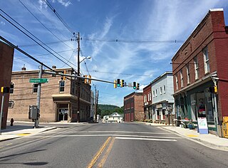
Eckhart Mines is an unincorporated community and census-designated place (CDP) in Allegany County, Maryland, United States. As of the 2010 census it had a population of 932.

The Maryland Mining Company is a historic coal mining, iron producer and railroad company that operated in Allegany County, Maryland.
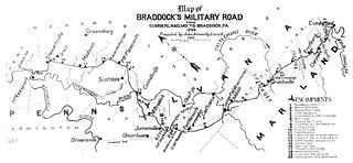
Cumberland, Maryland is named after the son of King George II, Prince William, the Duke of Cumberland. It is built on the site of the old Fort Cumberland, a launch pad for British General Edward Braddock's ill-fated attack on the stronghold of Fort Duquesne during the French and Indian War.
The Hoffman tunnel, or Hoffman drainage tunnel, was constructed to drain water from coal mines northwest of Clarysville in Allegany County, Maryland. The two-mile-long tunnel drains into the Braddock Run tributary of Wills Creek.
Barton Village Site, also known as the Herman Barton Indian Village Archeological Site, is an archaeological site near Cumberland in Allegany County, Maryland. The site was explored in 1960 by Henry Wright, whose work revealed six cultural layers representing three phases of late prehistoric occupation, c. 1000-1500. It represents data for the terminal Woodland to the terminal Prehistoric periods in the Upper Potomac River Valley. Significant evidence exists that the site was a village of the Monongahela culture.
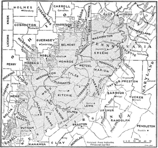
The Pittsburgh Coal Seam is the thickest and most extensive coal bed in the Appalachian Basin; hence, it is the most economically important coal bed in the eastern United States. The Upper Pennsylvanian Pittsburgh coal bed of the Monongahela Group is extensive and continuous, extending over 11,000 mi2 through 53 counties. It extends from Allegany County, Maryland to Belmont County, Ohio and from Allegheny County, Pennsylvania southwest to Putnam County, West Virginia.
The Mount Savage Iron Works operated from 1837 to 1868 in Mount Savage, Maryland. The ironworks were the largest in the United States in the late 1840s, and the first in the nation to produce heavy rails for construction of railroads. The works were established in an area adjacent to mines for coal, iron ore and fire clay. Facilities included blast furnaces, puddling furnaces, a rolling mill, iron refineries, coke production and brick production.

Western Maryland Regional Medical Center (WMRMC) is a hospital located in Cumberland, Maryland in Allegany County. The facility, which opened on November 21, 2009, is owned by the Western Maryland Health System (WMHS). It was established as a combination of Memorial Hospital (Cumberland) and Sacred Heart Hospital (Cumberland), both of which are now closed. It is sometimes confused with Western Maryland Hospital Center, a state-run rehabalitation hospital located in Hagerstown, Maryland.
The Pennsylvania Railroad in Maryland company was organized in 1876. According to its charter, it was to run from Cumberland, Maryland to the Pennsylvania line where it would connect with other branches of the Pennsylvania Railroad system and provide another outlet for Maryland's soft coal to the major industrial cities. The railroad had also been promoted by coal companies in the Georges creek valley in Maryland, principally the Maryland Coal Company and the American Coal Company as well as the city of Cumberland, Maryland to provide "the benefit of a competitive road with the Baltimore and Ohio railroad, then its only outlet." The Pennsylvania railroad wanted access to the Georges creek valley coal and potential customers such as the Maryland and American coal companies. To do so, meant bypassing the Cumberland and Pennsylvania railroad which was controlled by the Consolidation Coal company, the largest bituminous coal company in the eastern United States.. In 1873, the Baltimore and Ohio railroad had purchased a majority of the Consolidation Coal company's stock, thereby controlling coal exports out of the Georges creek valley and effectively the "entire output of coal in ."