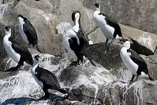
Egg Island is a small island, with an area of 0.83 ha, in south-eastern Australia. It is part of the North Coast Group, lying in Bass Strait on Horseshoe Reef near Devonport in north-west Tasmania. It has been identified as an Important Bird Area (IBA) because of its globally significant colony of black-faced cormorants. Wright Island is nearby.
Penguin Island is a small island, with an area of 2.73 ha, part of the North Coast Group, lying in the southern Bass Strait near Devonport in north-west Tasmania. It is part of the Narawntapu National Park. An estimated 100 pairs of little penguins breed on the island.

The Twin Islets form a close pair of small, steep-sided, granite islands, with a combined area of 5.61 ha, in south-eastern Australia. They are part of Tasmania’s Hogan Group, lying in northern Bass Strait between the Furneaux Group and Wilsons Promontory in Victoria.

Curtis Island is a granite island, with an area of 150 ha, in south-eastern Australia. It is part of Tasmania’s Curtis Group, lying in northern Bass Strait between the Furneaux Group and Wilsons Promontory in Victoria. It is a nature reserve and has been identified as an Important Bird Area because it supports up to 390,000 breeding pairs of short-tailed shearwaters or Tasmanian muttonbirds.
Cone Islet is a small granite island, with an area of 4.82 ha, in south-eastern Australia. It is part of Tasmania’s Curtis Group, lying in northern Bass Strait between the Furneaux Group and Wilsons Promontory in Victoria.
Sugarloaf Rock is a small granite island, with an area of 1.07 ha, in south-eastern Australia. It is part of Tasmania’s Curtis Group, lying in northern Bass Strait between the Furneaux Group and Wilsons Promontory in Victoria.

Devils Tower comprises two small and rugged granite islands, with a combined area of 4.77 hectares, in south-eastern Australia. It is part of Tasmania’s Curtis Group, lying in northern Bass Strait between the Furneaux Group and Wilsons Promontory in Victoria. It is a nature reserve.

Wright Rock is a small, steep-sided granite island, with an area of 9.36 ha, in south-eastern Australia. It is part of Tasmania’s Bass Pyramid Group, lying in northern Bass Strait between Flinders Island and the Kent Group. It has been a nature reserve since 5 April 1978.
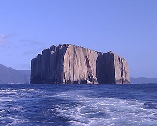
The Bass Pyramid, part of the Furneaux Group, is a small, two sectioned oval, steep-sided 100-square-metre (1,100 sq ft) unpopulated granite island, located in Bass Strait, lying north of the Flinders Island and south of the Kent Group, in Tasmania, Australia. A rock bridge connects the two sections.
Roydon Island is an island, with an area of 37 ha, in south-eastern Australia. It is part of Tasmania’s Pasco Island Group, lying in eastern Bass Strait off the north-west coast of Flinders Island in the Furneaux Group.
The Middle Pasco Islands comprise two similarly sized adjacent granite islands, with a combined area of 8.37 ha, in south-eastern Australia. They form part of Tasmania’s Pasco Island Group, lying in eastern Bass Strait off the north-west coast of Flinders Island in the Furneaux Group.

North Pasco Island is a granite island, with an area of 28 ha, in south-eastern Australia. It is part of Tasmania’s Pasco Island Group, lying in eastern Bass Strait off the north-west coast of Flinders Island in the Furneaux Group. It was previously used for sheep grazing.
The Low Islets are two small, flat, adjacent, granite islands, with a combined area of about 2 ha, in south-eastern Australia. They are part of Tasmania’s Prime Seal Island Group, lying in eastern Bass Strait west of Flinders in the Furneaux Group. The larger of the two islets has been used for grazing sheep, cattle and horses.

The Nuggets is a close group of four granite islets, with a combined area of 6.76 hectares, in south-eastern Australia. They lie close to the eastern coast of Tasmania near the Freycinet Peninsula., and are near Cape Tourville, about 7 km north of Wineglass Bay and about 22 km north of Schouten Island.

Picnic Island is a small, privately owned, rocky island, with an area of about one hectare, part of the Schouten Island Group, lying close to the eastern coast of Tasmania near the Freycinet Peninsula. It is composed of sandstone overlying granite.
Hippolyte Rocks is a small granite island, with an area of 5.3 ha, in south-eastern Australia. It is part of the Tasman Island Group, lying close to the south-eastern coast of Tasmania around the Tasman Peninsula. It has a flat top and is surrounded by steep cliffs up to 65 m in height. It is part of the Tasman National Park.

Sloping Island, incorporating the adjacent Sloping Reef, is an island nature reserve, with an area of 117 ha, in Tasmania in south-eastern Australia. It is part of the Sloping Island Group, lying close to the south-eastern coast of Tasmania around the Tasman and Forestier Peninsulas.
Sterile Island is a 3.68 ha island game reserve in south-eastern Australia. It is part of the Actaeon Island Group, lying close to the south-eastern coast of Tasmania, at the southern entrance to the D'Entrecasteaux Channel between Bruny Island and the mainland.
The Images is a 0.53 ha group of rocky islets and reefs, part of the Actaeon Island Group, lying close to the south-eastern coast of Tasmania, Australia at the southern entrance to the D'Entrecasteaux Channel between Bruny Island and the mainland.
Garden Island is a small stony island that is part of the Partridge Island Group, lying close to the south-eastern coast of Tasmania, Australia, in the D'Entrecasteaux Channel between Bruny Island and the mainland. The D'Entrecasteaux Channel is the mouth for the Huon River.