
Gordon is a suburb on the Upper North Shore of Sydney in the state of New South Wales, Australia 15 kilometres (9 mi) north-west of the Sydney Central Business District and is the administrative centre for the local government area of Ku-ring-gai Council. East Gordon is a locality within Gordon and West Gordon within West Pymble.

Warrawee is a suburb on the Upper North Shore of Sydney in the state of New South Wales, Australia. Warrawee is located 21 kilometres north-west of the Sydney Central Business District in the local government area of Ku-ring-gai Council. Warrawee is predominantly a small residential suburb with few commercial entities. Notably, its railway station provides no commercial activity which is uncommon in the Sydney train network.

Wahroonga is a suburb on the Upper North Shore of Sydney, in the state of New South Wales, Australia, 22 kilometres north-west of the Sydney central business district, in the local government area of Ku-ring-gai Council and Hornsby Shire.

Neutral Bay is a harbourside suburb on the Lower North Shore of Sydney, New South Wales, Australia. Neutral Bay is around 1.5 kilometres north of the Sydney central business district, in the local government area of North Sydney Council.

Killara, is a suburb on the Upper North Shore of Sydney in the state of New South Wales, Australia 14 kilometres (8.7 mi) north-west of the Sydney Central Business District in the local government area of Ku-ring-gai Council. East Killara is a separate suburb and West Killara is a locality within Killara.
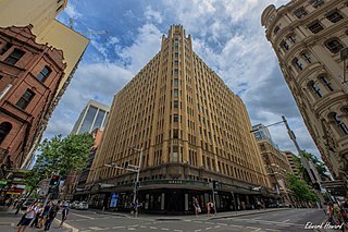
The Grace Building is an historic building of the Federation Skyscraper Gothic style that houses a bar, hotel, cafe and restaurant and is located at 77-79 York Street in the Sydney central business district in New South Wales, Australia.
The Riverview Hotel is an heritage-listed pub located in Balmain, a suburb in the inner west region of Sydney, in the state of New South Wales, Australia. Australian swimming champion, Dawn Fraser, was publican of the Riverview from 1978 to 1983.

Federation architecture is the architectural style in Australia that was prevalent from around 1890 to 1915. The name refers to the Federation of Australia on 1 January 1901, when the Australian colonies collectively became the Commonwealth of Australia.

Kurraba Point is a harbourside suburb on the lower North Shore of Sydney, New South Wales, Australia. Kurraba Point is located 4 kilometres north of the Sydney central business district, in the local government area of North Sydney Council.
Eryldene is a heritage-listed former family residence and now house museum located at 17 McIntosh Street in the Sydney North Shore suburb of Gordon, Ku-ring-gai Council, New South Wales, Australia. It was designed by William Hardy Wilson and built from 1913 to 1936 by Rudolph G. Ochs. The property is owned by The Eryldene Trust. The house and its garden, which is noted for its camellias was added to the New South Wales State Heritage Register on 2 April 1999 and was listed on the Australian Register of the National Estate.

Fernleigh Castle is a historic house in the Sydney suburb of Rose Bay. It is listed on the Australian Register of the National Estate.

Bertrand James Waterhouse was an English-born Australian architect and artist.
The Quadrangle is a prominent building of Sydney sandstone located within the University of Sydney Camperdown Campus. Taking over 100 years to complete, the Quadrangle was designed and developed by numerous contributors including Edmund Blacket, James Barnet, and Leslie Wilkinson. The original building included the Great Hall and was constructed between 1855 and 1862. Construction on the quadrangle began in 1854, it had four sides by 1926, and was completed in the 1960s after several stages of development. It comprises the Great Hall, MacLaurin Hall, Faculty of Arts office and the Nicholson Museum. MacLaurin Hall was constructed from 1902-1904 and was designed by Walter Liberty Vernon. The architectural style of the Quadrangle is gothic revival. The building is mostly constructed of Sydney sandstone and is unique in the Australian architectural landscape. At the time of its completion, the Quadrangle was ‘the largest public building in the colony.’ The Traditional Indigenous owners of the land on which the Quadrangle was built are the Cadigal and Wangal tribes of the Eora people. The main entrance - constructed first along with the Great Hall - is underneath the clock tower, which holds one of only two carillons in Australia.

The Leichhardt Town Hall is a landmark civic building in Leichhardt, a suburb of Sydney, Australia. It stands at 107 Norton Street. It was built in 1888 in the Victorian Italianate style by architects Drake and Walcott. The Town Hall was the seat of Leichhardt Municipal Council from 1888 to 2016 and is now one of the seats of the new Inner West Council. The hall is currently listed on the Register of the National Estate.

The Glebe Town Hall is a landmark civic building in Glebe, a suburb of Sydney, Australia. It stands at 160 St Johns Road and was built in 1880 in the Victorian Italianate style by architect Ambrose Thornley. The Town Hall was the seat of The Glebe Municipal Council from 1880 to 1948 when it became a community centre and hall run by the City of Sydney. After being transferred to the Municipality of Leichhardt in 1968, it was returned to the control of the City of Sydney following a boundary change on 8 May 2003. The council commissioned extensive restoration works in 2008, which were completed in 2013, and the hall is now heritage listed on the Sydney Local Environmental Plan as "representative as the seat of local metropolitan government for Glebe Municipality, the fourth municipality to be incorporated under The Municipalities Act of 1858." It is also listed on the Register of the National Estate.

Eben Gowrie Waterhouse OBE CMG (1881–1977) was an Australian who had three distinguished careers. Starting out as an innovative teacher of languages, he became one of Australia's most prominent Germanists when classical German culture still commanded worldwide respect. Between the Wars in Sydney he was a leading arbiter of taste in house-and-garden living, fostering a conception of garden design which still dominates much of the Sydney North Shore and parts of Melbourne. Finally, in his long retirement he brought about, as scholar and plant-breeder, an international revival of interest in the genus Camellia.

The Treasury Building, or the Colonial Treasury Building, The Old Treasury Building, or the Treasury Building & Premier's Office, is an heritage-listed former government administration building and now hotel located at the junction of Macquarie and Bridge streets in the central business district of Sydney in New South Wales, Australia. Commenced in 1849 and completed in stages in 1851, 1853, 1900 and 1919 in the Victorian Neo-Classical and Italian Palazzo styles by NSW Colonial and Government architects Mortimer Lewis, Edmund Blacket, Walter Liberty Vernon, and George McRae, the building has been used variously by the NSW Treasury, the Audit Office, the Premier's Department, the Police Department, and the Ministry of Transport. In 1981 the building was sold to the InterContinental Hotel group, with a major hotel complex built on part of the site and much of the heritage building restored.

2-4 Trinity Avenue, Millers Point is a heritage-listed residence at 2-4 Trinity Avenue, in the inner city Sydney suburb of Millers Point in the City of Sydney local government area of New South Wales, Australia. It was designed by the NSW Government Architect. The property was added to the New South Wales State Heritage Register on 2 April 1999.
30-42 Lower Fort Street, Millers Point are heritage-listed terrace houses located at 30-42 Lower Fort Street, in the inner city Sydney suburb of Millers Point in the City of Sydney local government area of New South Wales, Australia. It was designed by the NSW Government Architect. The property was added to the New South Wales State Heritage Register on 2 April 1999.


