
The Scheyville National Park is a protected national park that is located in the northwestern suburbs of Sydney in New South Wales, in eastern Australia. The 920-hectare (2,300-acre) national park is situated approximately 40 kilometres (25 mi) northwest of the Sydney central business district, northeast of Windsor, near the settlement of Scheyville. Longneck Lagoon lies in the northern section of the park. It was added to the New South Wales State Heritage Register on 9 April 2010.

Castle Hill is a suburb of Sydney, New South Wales, Australia, located 34 kilometres north-west of the Sydney central business district and 9.5 kilometres north of Parramatta. It is within the Hills District region, split between the local government areas of The Hills Shire and Hornsby Shire.

The Hills District is a region of Sydney, within the northern part of the Greater Western Sydney region of Sydney, in the state of New South Wales, Australia.

Taralga is a small village in the Southern Tablelands of New South Wales, Australia, in Upper Lachlan Shire. It is located at the intersection of the Goulburn-Oberon Road and the Laggan-Taralga Road. It is accessible from Oberon to the north, Mittagong to the east, Goulburn to the south, and Crookwell to the west. At the 2016 census, Taralga had a population of 467. Taralga is located relatively close to the famous Wombeyan Caves. The town experiences a volatile climate and is often affected by snow in the winter months.
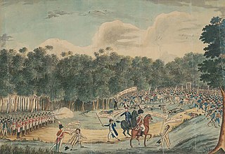
The Castle Hill convict rebellion was a convict rebellion in Castle Hill, Sydney, then part of the British colony of New South Wales. Led by veterans of the Irish Rebellion of 1798, the poorly armed insurgents confronted the colonial forces of Australia on 5 March 1804 at Rouse Hill. Their rout in the resulting skirmish was hailed by as loyalists as "Australia's Vinegar Hill" after the 1798 battle of Vinegar Hill, where Society of United Irishmen rebels were decisively defeated. The incident was the first major convict uprising in Australian history to be suppressed under martial law.
Riverstone is a suburb of Sydney in the state of New South Wales, Australia. Riverstone is located 48 kilometres (30 mi) north-west of the Sydney central business district, in the Blacktown local government area and part of the Greater Western Sydney region. Originally settled in 1803 as part of a government stock farm, Riverstone is one of the oldest towns in Australia.
Rouse Hill is a suburb of Sydney, in the state of New South Wales, Australia. Rouse Hill is located in the Hills District, 43 kilometres north-west of the Sydney central business district and 19 kilometres north-west of the Parramatta central business district. It is in the local government areas of The Hills Shire and City of Blacktown. Rouse Hill Town Centre is at the heart of the suburb, which contains a busy Town Square.

The Sydney Mint in Sydney, New South Wales, Australia, is the oldest surviving public building in the Sydney central business district. Built between 1811 and 1816 as the southern wing of the Sydney Hospital, it was then known as the Rum Hospital. In 1854 a mint was established on the site with the hospital building used to house mint staff as well as providing a residence for the Deputy Mint Master. A coining factory was built at the rear. Both of these structures have exceptional heritage significance and have been associated with major events in the colonial history of New South Wales.

The Hyde Park Barracks, Sydney is a heritage-listed former barracks, hospital, convict accommodation, mint and courthouse and now museum and café located at Macquarie Street in the Sydney central business district, in the City of Sydney local government area of New South Wales, Australia. Originally constructed between 1817 and 1819 as a brick building and compound to house convict men and boys, it was designed by convict architect Francis Greenway. It is also known as the Mint Building and Hyde Park Barracks Group and Rum Hospital; Royal Mint – Sydney Branch; Sydney Infirmary and Dispensary; Queen's Square Courts; Queen's Square. The site is managed by the Museums of History New South Wales, an agency of the Government of New South Wales, as a living history museum open to the public.
Against the Wind is a 1978 Australian television miniseries. It is a historical drama portraying both the British rule of Ireland, and the development of New South Wales and Australia.

Michael Dwyer was an insurgent captain in the Irish Rebellion of 1798, leading the United Irish forces in battles in Wexford and Wicklow. Following the defeat and dispersal of the rebel hosts, in July 1798 Dwyer withdrew into the Wicklow Mountains, and to his native Glen of Imaal, where he sustained a guerrilla campaign against British Crown forces.
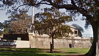
Fort Phillip was a citadel style fort constructed as part of the first defensive works of the penal settlement of Sydney, located on Observatory Hill in the Sydney suburb of Millers Point, New South Wales, Australia. The fort has been demolished and the local government heritage-listed site repurposed as the Sydney Observatory.

Prospect Hill, or Marrong Reserve, is a heritage-listed hill in Pemulwuy and Prospect in the greater western region of Sydney, New South Wales, Australia. Situated about 30 kilometres west of central Sydney, the hill is Sydney's largest body of igneous rock and is higher than the ridges of the Cumberland Plain around it, with its present-day highest point being 117 metres high, although before its summit was quarried away it rose to a height of 131 metres above sea level.

Prince Alfred Square is a 1.5-hectare (3.7-acre) park on the northern side of the Parramatta River in the central business district of Parramatta. It is one of the oldest public parks in New South Wales and is listed on the New South Wales State Heritage Register. St Patrick's Cathedral is located directly opposite the square to the west.

Lidcombe Hospital Precinct is a heritage-listed former hospital and home for the aged, now converted to private housing, located at Joseph Street, Lidcombe, Cumberland Council, New South Wales, Australia. It was designed by James Barnet, Walter Liberty Vernon, Cobden Parkes and Ken Woolley and built from 1885 by the Government of New South Wales. It is also known as Rookwood Asylum for the Aged and Infirm; Rookwood State Hospital and Asylum for Men; Lidcombe State Hospital & Home; Rookwood Boys Reformatory & Model Farm. The property is now owned by Australand Industrial No. 18 Pty Limited and the Sydney Olympic Park Authority. It was added to the New South Wales State Heritage Register on 24 February 2006.

Merriville House & Gardens is a heritage-listed residence at Eire Way, Kellyville Ridge, New South Wales, Australia. It was built from 1817 to 1855. It is also known as Hambledon Cottage, Hambledon and Maryville. It was added to the New South Wales State Heritage Register on 2 April 1999.

The Royal Oak Inn is a heritage-listed hotel located on the corner of Windsor Road and Commercial Road, in Rouse Hill in The Hills Shire local government area of New South Wales, Australia. It was built in 1829. It has also been known as the Queens Arms Inn, and is currently known as the Fiddler Hotel. The property is privately owned and was added to the New South Wales State Heritage Register on 2 April 1999.
The Toongabbie Government Farm Archaeological Site is the heritage-listed site of a former convict government farm at Goliath Avenue, Winston Hills, City of Parramatta, New South Wales, Australia. The farm was built by convict labour from 1791 to 1813. Its site includes areas today known as Palestine Park, Oakes Reserve and Settlers Walk and is also known as the Toongabbie Government Farm Convict Site. It was added to the New South Wales State Heritage Register on 11 December 2012.

Brush Farm is a heritage-listed former farm, residence and vineyard and now tourist attraction, community facility, exhibition venue and meeting venue at Marsden Road, Eastwood, New South Wales, a suburb of Sydney, Australia. It was built from 1794 to 1894. It is also known as Home for Boys, Eastwood Home for Mothers and Babies and Brush Farm Home for Mentally Deficient Children, and Brush Farm Girls' Home. The property is owned by City of Ryde. It was added to the New South Wales State Heritage Register on 2 April 1999.

Newcastle Government House is a heritage-listed former military post and official residence and now park and psychiatric hospital at 72 Watt Street, Newcastle, New South Wales, Australia. It is also known as Newcastle Government House and Domain, Newcastle Military Barracks & Hospital, Newcastle Industrial School for Girls, Reformatory for Girls, Lunatic Asylum for Imbeciles, James Fletcher Hospital and Fletcher Park. It was added to the New South Wales State Heritage Register on 22 March 2011.


