Related Research Articles

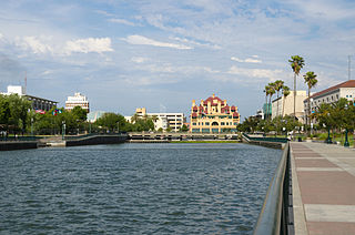
Palo Alto is a charter city in the northwestern corner of Santa Clara County, California, United States, in the San Francisco Bay Area, named after a coastal redwood tree known as El Palo Alto.

The Central Valley is a broad, elongated, flat valley that dominates the interior of California. It is 40–60 mi (60–100 km) wide and runs approximately 450 mi (720 km) from north-northwest to south-southeast, inland from and parallel to the Pacific coast of the state. It covers approximately 18,000 sq mi (47,000 km2), about 11% of California's land area. The valley is bounded by the Coast Ranges to the west and the Sierra Nevada to the east.
Stockton is a city in and the county seat of San Joaquin County in the Central Valley of the U.S. state of California. Stockton is the largest city in the county, the 11th largest city in California and the 58th largest city in the United States. Stockton's population in 2020 was 320,804. It was named an All-America City in 1999, 2004, 2015, and again in 2017. The city is located on the San Joaquin River in the northern San Joaquin Valley. It lies at the southeastern corner of a large inland river delta that isolates it from other nearby cities such as Sacramento and those of the San Francisco Bay Area.

The Santa Clara Valley is a geologic trough in Northern California that extends 90 miles (140 km) south–southeast from San Francisco to Hollister. The longitudinal valley is bordered on the west by the Santa Cruz Mountains and on the east by the Diablo Range; the two coastal ranges meet south of Hollister. The San Francisco Bay borders the valley to the north, and fills much of the northern third of the valley. The valley floor is an alluvial plain that formed in the graben between the San Andreas Fault to the west and the Hayward and Calaveras faults to the east. Within the valley and surrounding the bay on three sides are the urban communities of San Mateo County, Santa Clara County, and Alameda County, while the narrow southern reaches of the valley extend into rural San Benito County to Hollister. In practical terms, the central portion of the Santa Clara Valley is often considered by itself, contained entirely within Santa Clara County.

Alviso is a district of San Jose, California, located in North San Jose on the southern shores of San Francisco Bay. Originally an independent town, founded in 1852, today Alviso is San Jose's only waterfront district, primarily residential in nature, with several Silicon Valley tech companies and recreation-oriented businesses. Alviso is named after 19th-century Californio ranchero Ignacio Alviso, who owned the area as part of his Rancho Rincón de Los Esteros.
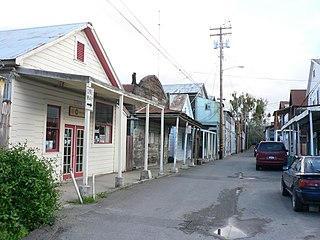
Locke, also known as Locke Historic District, is an unincorporated community in the Sacramento–San Joaquin River Delta of California, United States. The 14-acre town (5.7 ha) was first developed between 1893 and 1915 approximately one mile north of the town of Walnut Grove in Sacramento County.

El Palo Alto is a coast redwood located on the banks of the San Francisquito Creek in Palo Alto, California, a city in the San Francisco Bay Area. The namesake of the city and a historical landmark, El Palo Alto is 1082–1083 years old and stands 110 feet (34 m) tall.

The Sacramento–San Joaquin River Delta, or California Delta, is an expansive inland river delta and estuary in Northern California. The Delta is formed at the western edge of the Central Valley by the confluence of the Sacramento and San Joaquin rivers and lies just east of where the rivers enter Suisun Bay, which flows into San Francisco Bay, then the Pacific Ocean via San Pablo Bay. The Delta is recognized for protection by the California Bays and Estuaries Policy. Sacramento–San Joaquin Delta was designated a National Heritage Area on March 12, 2019. The city of Stockton is located on the San Joaquin River at the eastern edge of the delta. The total area of the Delta, including both land and water, is about 1,100 square miles (2,800 km2). Its population is around 500,000.

The Sacramento Bee is a daily newspaper published in Sacramento, California, in the United States. Since its foundation in 1857, The Bee has become the largest newspaper in Sacramento, the fifth largest newspaper in California, and the 27th largest paper in the U.S. It is distributed in the upper Sacramento Valley, with a total circulation area that spans about 12,000 square miles (31,000 km2): south to Stockton, California, north to the Oregon border, east to Reno, Nevada, and west to the San Francisco Bay Area.

Franks Tract State Recreation Area (SRA) is a state park unit of California, United States, featuring a flooded area in the Sacramento–San Joaquin River Delta. It is accessible only by water. Franks Tract, and a smaller adjoining submerged property called "Little Franks Tract", are situated between the False River and Bethel Island. The recreation area is used primarily for fishing and waterfowl hunting, because of its exposure to frequent strong winds and fluctuating water levels. In times of high water, the entire site can be submerged except for portions of the old levees. The 3,523-acre (1,426 ha) park was established in 1959. It is managed from nearby Brannan Island State Recreation Area, 6 miles (9.7 km) to the northwest.
Lew Hing (formal married name was Lew Yu-ling; Chinese: 劉興; May 1858–March 7, 1934) was a Chinese-born American industrialist and banker. He was the founding father of Chinatown in San Francisco, as well as Chinatown in Oakland, California and eventually one of the wealthiest Chinese immigrants in America.
Santa Clara County, California, is one of California's original counties, with prior habitation dating from prehistory to the Alta California period.

The Isleton Chinese and Japanese Commercial Districts is located in Isleton, California in the Sacramento–San Joaquin River Delta, a large agricultural area in Sacramento County, California. Also known as the Isleton Asian American District, it served as the commercial and social center for both the town's Chinese and Japanese residents and the laborers working in nearby canneries, farms, and ranches. Isleton Asian American District is the only Asian community built in the Delta during the 1920s, and the architectural style of the buildings in the districts, particularly the use of pressed tin siding, is unique to other Delta Asian communities and to the town of Isleton.
The Los Altos Town Crier is an American independently owned paid newspaper which serves the city of Los Altos and surrounding Santa Clara County, California. The newspaper was founded in 1947 and covers local news, sports, business and community events. It is published weekly on Wednesday and is mailed to the households of the residents of Los Altos, Los Altos Hills and Mountain View. According to the American Newspaper Representatives, the Los Altos Town Crier has a total circulation of 16,500. The paper's Editor-in-Chief is Bruce Barton and it is owned by LATC Media Inc.

Bradford Island is a 2,172-acre (879 ha) island of the Sacramento–San Joaquin River Delta, in Contra Costa County, California, United States. Bradford Island is inaccessible by roads, and is served by a ferry across the False River from nearby Jersey Island. Approximately 48 people lived on the island as of 2020; other uses of land include wheat farming, cattle grazing, and natural gas extraction.

Kimball Island is a small island in the Sacramento–San Joaquin River Delta. It is located in Sacramento County, California, in the United States. Since its discovery, it has been used to grow barley, farm fish, cultivate cannabis, and as residential land. Currently, however, it is uninhabited; since 2000, it has been left to "forever be a wetland habitat", and is sometimes used as a fishing spot.

The Empire Tract is an island in the Sacramento–San Joaquin River Delta in San Joaquin County, California, United States. It has been used for agriculture since the 1800s; in the early 20th century it was used to plant potatoes, and United States president Herbert Hoover operated a beet farm there. In the 1960s, natural gas deposits were discovered beneath the island. In 1936, it was connected to the mainland by the Eight Mile Road Bridge, across King Island. As with many islands in the Delta, the Empire Tract has experienced considerable subsidence, and is well below sea level.

The Terminous Tract is an island in the Sacramento–San Joaquin River Delta. It is part of San Joaquin County, California, and managed by Reclamation District 548. Its coordinates are 38°06′45″N121°27′27″W, and the United States Geological Survey measured its elevation as −7 ft (−2.1 m) in 1981. The census-designated place of Terminous, California is on the island.

Linda Gass is an American environmental activist and artist known for brightly colored quilted silk landscapes, environmental works, and public art sculptures, which reflect her passion for environmental preservation, water conservation and land use.
Kamajiro Hotta was an influential Japanese immigrant farmer in the state of California during the early 20th century. His primary contributions to the California farming industry were in Walnut Grove. While he grew many different crops during his time in the United States, he is most commonly known for growing asparagus. Following his first major land acquisitions in 1904, Hotta's farming career boomed because of his unique land contracts that gave him more autonomy over business operations than other Japanese immigrant farmers at the time.
References
- 1 2 3 Robin Chapman (October 10, 2018). "Santa Clara Valley Lives: Thomas Foon Chew: The man who made a difference". Los Altos Town Crier. Retrieved January 27, 2023.
- ↑ Tsu, Cecilia M. (2013). Garden of the world: Asian immigrants and the making of agriculture in California's Santa Clara Valley. Oxford/New York: Oxford University Press. ISBN 978-0-19-987596-2.
- 1 2 Chapman, Robin (11 September 2019). "Rediscovering Thomas Foon Chew: The legacy of Bay Side Cannery owner". Los Altos Town Crier. Retrieved 24 July 2023.
- ↑ "Fry's building's storied history".
- ↑ Annette Ashton. "Midtown History: Gloria Hom". Midtown Residents Association. Retrieved January 27, 2023.
- ↑ Gloria Hom (April 4, 2019). "Thomas Foon Chew: A Visionary in his Time" . Retrieved January 27, 2023.
- ↑ Angst, Maggie (August 29, 2019). "Fry's to close its Palo Alto doors for good in January". The Mercury News . San Jose. Retrieved September 21, 2019.
- ↑ Neil Gonzales (September 6, 2023). "Community debates Sobrato project one last time before council decision—The 14-acre parcel includes the former home of Fry's Electronics, which was once a fruit and vegetable cannery" . Retrieved September 11, 2023.
- ↑ "When Asparagus was King" (PDF). Locke Foundation Newsletter. No. Winter 2015. 2015. Retrieved 24 July 2023.
- ↑ Leung, Peter C.Y.; Ma, L. Eve Armentrout (January 1988). "Chinese Farming Activities in the Sacramento-San Joaquin Delta: 1910–1941". Amerasia Journal. 14 (2): 1–18. doi:10.17953/amer.14.2.p4672039852016j7.
| | This Chinese biographical article is a stub. You can help Wikipedia by expanding it. |