Thomas Shoal may refer to:
In the Spratly Islands
In the United States
- Thomas Point Shoal, Chesapeake Bay, Maryland
The term may also relate to
Thomas Shoal may refer to:
In the Spratly Islands
In the United States
The term may also relate to

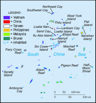
The Spratly Islands are a disputed archipelago in the South China Sea. Composed of islands, islets, cays, and more than 100 reefs, sometimes grouped in submerged old atolls, the archipelago lies off the coasts of the Philippines, Malaysia, and southern Vietnam. Named after the 19th-century British whaling captain Richard Spratly who sighted Spratly Island in 1843, the islands contain less than 2 km2 of naturally occurring land area, which is spread over an area of more than 425,000 km2 (164,000 sq mi).

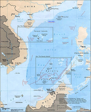
The South China Sea is a marginal sea of the Western Pacific Ocean. It is bounded in the north by the shores of South China, in the west by the Indochinese Peninsula, in the east by the islands of Taiwan and northwestern Philippines, and in the south by the Indonesian islands of Borneo, eastern Sumatra and the Bangka Belitung Islands, encompassing an area of around 3,500,000 km2 (1,400,000 sq mi). It communicates with the East China Sea via the Taiwan Strait, the Philippine Sea via the Luzon Strait, the Sulu Sea via the straits around Palawan, and the Java Sea via the Karimata and Bangka Straits. The Gulf of Thailand and the Gulf of Tonkin are also part of South China Sea.

The South China Sea Islands consist of over 250 islands, atolls, cays, shoals, reefs and seamounts in the South China Sea. The islands are mostly low and small, and have few inhabitants. The islands and surrounding seas are subject to overlapping territorial claims by the countries bordering the South China Sea.

Scarborough Shoal, also known as Bajo de Masinloc, Panatag Shoal, Huangyan Island, and Democracy Reef, are two rocks in an atoll administrated by China in the South China Sea. It is located between Macclesfield Bank, a sunken atoll of underwater reefs and shoals east of the Paracel islands and Luzon, the nearest landmass, 220 kilometres (119 nmi) away and the largest island of the Philippines.

Kalayaan, officially the Municipality of Kalayaan, is a 5th class municipality in the South China Sea under the jurisdiction of the province of Palawan, Philippines. According to the 2020 census, it has a population of 193 people making it the least populated town in the Philippines.
Patag may refer to:
The Philippines has claimed many territories throughout its history. These territories include the Spratly Islands, portions of North Borneo, and the Scarborough Shoal.

USS LST-821, renamed USS Harnett County (LST-821/AGP-281), is an LST-542-class tank landing ship built for the United States Navy during World War II. She was named for Harnett County, North Carolina and was the only U.S. Naval vessel to bear the name. She served the United States Navy in World War II and the Vietnam War. She was transferred to South Vietnam's Republic of Vietnam Navy, which named her RVNS My Tho (HQ-800).
Nansha may refer to the following places:

Philippines and the Spratly Islands – this article discusses the policies, activities and history of the Republic of the Philippines in the Spratly Islands from the Philippine perspective. Non-Philippine viewpoints regarding Philippine occupation of several islands are currently not included in this article.

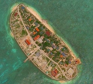
Sand Cay10°22′30″N114°28′48″E, also known as Bailan Island ; Son Ca Island ; Mandarin Chinese: 敦謙沙洲/敦谦沙洲; pinyin: Dūnqiān Shāzhōu, is a cay on the north edge of the Tizard Bank of the Spratly Islands in the South China Sea. With an area of 7 hectares, it is the ninth largest, and the fourth largest former Vietnamese-administered, of the Spratly Islands. The island has been occupied by Vietnam since 1974,. It is also claimed by China (PRC), the Philippines, Vietnam, and Taiwan (ROC).

The Spratly Islands dispute is an ongoing territorial dispute between China, the Philippines, Taiwan, Malaysia, Vietnam, and Brunei, concerning "ownership" of the Spratly Islands, a group of islands and associated "maritime features" located in the South China Sea. The dispute is characterized by diplomatic stalemate and the employment of military pressure techniques in the advancement of national territorial claims. All except Brunei occupy some of the maritime features.

Investigator Shoal, also known as Malay: Terumbu Peninjau; Pawikan Shoal ; Vietnamese: bãi Thám Hiểm; Mandarin Chinese: 榆亚暗沙; pinyin: Yúyà ànshā, is located in the SW of Dangerous Ground in the Spratly Islands of the South China Sea.

Dangerous Ground is a large area in the southeast part of the South China Sea characterized by many low islands and cays, sunken reefs, and atolls awash, with reefs often rising abruptly from ocean depths greater than 1,000 metres (3,300 ft).

Second Thomas Shoal, also known as Ayungin Shoal, is an atoll in the Spratly Islands of the South China Sea, 105 nautical miles west of Palawan, Philippines. Claimed by several nations but located in the exclusive economic zone of the Philippines, the atoll is currently militarily occupied by the Philippines.

Sabina Shoal, also known as Escoda Shoal ; Mandarin Chinese: 仙賓礁/仙宾礁; pinyin: Xiānbīn Jiāo; Vietnamese: Bãi Sa Bin, is an atoll in the NE of Dangerous Ground in the Spratly Islands. The Philippines puts it under the jurisdiction of Brgy. Pag-asa, Kalayaan, Palawan. It is claimed by the People's Republic of China, and the Republic of China (Taiwan).
Bombay Castle is a fort in Mumbai

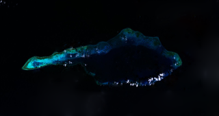
First Thomas Shoal, also known as Bulig Shoal in the Philippines, Bãi Suối Ngà in Vietnam, and 信义礁 in China, is an uninhabited reef/atoll located 29 nautical miles south of Second Thomas Shoal in the Spratly Islands of the South China Sea.
Third Thomas Shoal, known as Banko Thomas in the Philippines, Bãi Đồng Cam in Vietnam, and 和平暗沙 in China, is a reef in the north-west of the Spratly Islands in the South China Sea. It is located 7.5 nautical miles north of Flat island, and 73 nautical miles north of Mischief Reef.