Thorne, Cornwall

Last updated

Thorne Farm, Whitstone Thorne Farm - geograph.org.uk - 929453.jpg
Thorne Farm, Whitstone

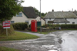
Thorne is the name of two hamlets in north Cornwall, England, United Kingdom. One is on the A3073 road near Bude and the other near Whitstone. Thorne, Whitstone, was a manor in medieval times and had in 1086 land for one plough and 20 acres of pasture. [1] [2]

Cornwall County of England

Cornwall is a ceremonial county in South West England, bordered to the north and west by the Celtic Sea, to the south by the English Channel, and to the east by Devon, the River Tamar forming the border between them. Cornwall is the westernmost part of the South West Peninsula of the island of Great Britain. The southwesternmost point is Land's End and the southernmost Lizard Point. Cornwall has a population of 563,600 and an area of 3,563 km2 (1,376 sq mi). The county has been administered since 2009 by the unitary authority, Cornwall Council. The ceremonial county of Cornwall also includes the Isles of Scilly, which are administered separately. The administrative centre of Cornwall is Truro, its only city.

Bude town in Cornwall, England

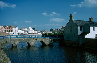
Bude is a small seaside resort town in north east Cornwall, England, in the civil parish of Bude-Stratton and at the mouth of the River Neet. It was sometimes formerly known as Bude Haven. It lies southwest of Stratton, south of Flexbury and Poughill, and north of Widemouth Bay and is located along the A3073 road off the A39. Bude is twinned with Ergué-Gabéric in Brittany, France. Bude's coast faces Bude Bay in the Celtic Sea, part of the Atlantic Ocean. The population of the civil parish can be found under Bude-Stratton.

Whitstone village and civil parish in east Cornwall, England

Whitstone is a village and civil parish in east Cornwall, United Kingdom. It is roughly halfway between the towns of Bude and Launceston. The population at the 2011 census was 590.

Related Research Articles

North Cornwall district of Cornwall

North Cornwall is an area of Cornwall, England, United Kingdom. It is also the name of a former local government district, which was administered from Bodmin and Wadebridge 50.516°N 4.835°W. Other towns in the area are Launceston, Bude, Padstow, and Camelford.

Coombe, Bude village in United Kingdom

Coombe is a hamlet in northeast Cornwall, England, United Kingdom.

North Cornwall (UK Parliament constituency) Parliamentary constituency in the United Kingdom, 1918 onwards

North Cornwall is a constituency represented in the House of Commons of the UK Parliament by Scott Mann, a Conservative.

Bude–Stratton civil parish in Cornwall, England in the United Kingdom

Bude–Stratton is a coastal civil parish with a town council in Cornwall, England, United Kingdom. According to the 2001 census it had a population of 9,242. In 2011 this population had increased to 9,934.

Stratton, Cornwall Church

Stratton is a small town, parish and former manor situated near the coastal town of Bude in north Cornwall, England. It was also the name of one of ten ancient administrative Hundreds of Cornwall. The Battle of Stratton during the Civil War took place here on 16 May 1643.

The Okehampton–Bude line was a railway line built to serve Holsworthy in Devon, and Bude on the Cornish coast near the Devon border in England. The line branched from the main line at Meldon Junction to the west of Okehampton on the northern edge of Dartmoor. The line opened in 1879 to Holsworthy and in 1898 to Bude. It is now closed.

Bridgerule farm village in the United Kingdom

Bridgerule is a village and civil parish in Devon, England, a mile from the border with Cornwall. The parish is divided by the River Tamar, which no longer forms the border between Devon and Cornwall there. The river often floods the High Street. An electoral ward exists in the area titled Tamarside. The population at the 2011 census was 1,734

Adam Black is a rugby union player. A prop forward, Black has represented England at Under 21 level.

North Tamerton human settlement in United Kingdom

North Tamerton is a village and civil parish in east Cornwall, England, UK. The village is situated approximately eight miles (13 km) southeast of Bude and eight miles (13 km) north of Launceston.

Whitstone is a village in Cornwall, United Kingdom.

Shop is a hamlet near Bude in Cornwall, England, United Kingdom.

Stibb hamlet in Cornwall, England

Stibb is a hamlet near Bude in Cornwall, England, United Kingdom.

West Youlstone human settlement in United Kingdom

West Youlstone is a hamlet in north Cornwall, England, United Kingdom. It lies seven miles north north west of Bude and north of Kilkhampton along the A39 road. It belongs to the parish of Morwenstow, and lies to the east of it. East Youlstone is immediately to the east but is in Devon.

Lymsworthy Meadows is a Site of Special Scientific Interest (SSSI) in north Cornwall, England, UK, noted for its biological characteristics.

Whitstone and Bridgerule railway station

Whitstone and Bridgerule was a railway station on the Bude Branch that closed in 1966. The station was opened in 1898 by the London and South Western Railway (LSWR) when the line was extended from Holsworthy station to the new terminus of the line at Bude.

Budehaven Community School is a coeducational foundation secondary school and sixth form, located in Bude in the English county of Cornwall.

Bude RFC

Bude RFC is a Cornish rugby union club that is based in the town of Bude and was formed in 1966. The club colours are maroon and blue and they have 2 senior men's teams, a colts side and multiple junior/mini teams. The men's first team play in Tribute Cornwall/Devon having been relegated from Tribute Western Counties West at the end of the 2016–17 season.

References

  1. Thorn, Caroline, et al. (eds.) (1979) Cornwall (Domesday Book; 10.) Chichester: Phillimore; entry 5,5,8
  2. Ordnance Survey (1946) One-inch Map of England and Wales; Bude, sheet 174