
Climate is the long-term weather pattern in a region, typically averaged over 30 years. More rigorously, it is the mean and variability of meteorological variables over a time spanning from months to millions of years. Some of the meteorological variables that are commonly measured are temperature, humidity, atmospheric pressure, wind, and precipitation. In a broader sense, climate is the state of the components of the climate system, including the atmosphere, hydrosphere, cryosphere, lithosphere and biosphere and the interactions between them. The climate of a location is affected by its latitude, longitude, terrain, altitude, land use and nearby water bodies and their currents.

In geography, the temperate climates of Earth occur in the middle latitudes, which span between the tropics and the polar regions of Earth. These zones generally have wider temperature ranges throughout the year and more distinct seasonal changes compared to tropical climates, where such variations are often small and usually only have precipitation changes.

A Mediterranean climate, also called a dry summer climate, described by Köppen as Cs, is a temperate climate type that occurs in the lower mid-latitudes. Such climates typically have dry summers and wet winters, with summer conditions ranging from warm to hot and winter conditions typically being mild to cool. These weather conditions are typically experienced in the majority of Mediterranean-climate regions and countries, but remain highly dependent on proximity to the ocean, altitude and geographical location.

The subtropical zones or subtropics are geographical and climate zones to the north and south of the tropics. Geographically part of the temperate zones of both hemispheres, they cover the middle latitudes from 23°26′10.3″ (or 23.4362°) to approximately 35° north and south. The horse latitudes lie within this range.

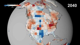
The Köppen climate classification is one of the most widely used climate classification systems. It was first published by German-Russian climatologist Wladimir Köppen (1846–1940) in 1884, with several later modifications by Köppen, notably in 1918 and 1936. Later, German climatologist Rudolf Geiger (1894–1981) introduced some changes to the classification system in 1954 and 1961, which is thus sometimes called the Köppen–Geiger climate classification.
Potential evaporation (PE) or potential evapotranspiration (PET) is defined as the amount of evaporation that would occur if a sufficient water source were available. If the actual evapotranspiration is considered the net result of atmospheric demand for moisture from a surface and the ability of the surface to supply moisture, then PET is a measure of the demand side. Surface and air temperatures, insolation, and wind all affect this. A dryland is a place where annual potential evaporation exceeds annual precipitation.

A semi-arid climate, semi-desert climate, or steppe climate is a dry climate sub-type. It is located on regions that receive precipitation below potential evapotranspiration, but not as low as a desert climate. There are different kinds of semi-arid climates, depending on variables such as temperature, and they give rise to different biomes.

A humid continental climate is a climatic region defined by Russo-German climatologist Wladimir Köppen in 1900, typified by four distinct seasons and large seasonal temperature differences, with warm to hot summers and cold winters. Precipitation is usually distributed throughout the year, but often these regions do have dry seasons. The definition of this climate in terms of temperature is as follows: the mean temperature of the coldest month must be below 0 °C (32.0 °F) or −3 °C (26.6 °F) depending on the isotherm, and there must be at least four months whose mean temperatures are at or above 10 °C (50 °F). In addition, the location in question must not be semi-arid or arid. The cooler Dfb, Dwb, and Dsb subtypes are also known as hemiboreal climates.

London features a temperate oceanic climate (Cfb). This gives the city cool winters, warm summers with precipitation fairly evenly distributed all year round. London has a very rich history of meteorological observations, with precipitation records beginning as early as January 1697 at Kew Gardens. Irregular observations were made at multiple locations in the ensuing years. An observing station has been located at Greenwich since 1841, giving London its longest continuous reliable temperature series. Other stations include Heathrow, beginning in 1948, Hampstead, beginning in 1910, Northolt, beginning in 1948, and St James's Park, beginning in 1910.
An aridity index (AI) is a numerical indicator of the degree of dryness of the climate at a given location. The American Meteorological Society defined it in meteorology and climatology, as "the degree to which a climate lacks effective, life-promoting moisture". Aridity is different from drought because aridity is permanent whereas drought is temporary. A number of aridity indices have been proposed ; these indicators serve to identify, locate or delimit regions that suffer from a deficit of available water, a condition that can severely affect the effective use of the land for such activities as agriculture or stock-farming.

Climate classifications are systems that categorize the world's climates. A climate classification may correlate closely with a biome classification, as climate is a major influence on life in a region. One of the most used is the Köppen climate classification scheme first developed in 1884.
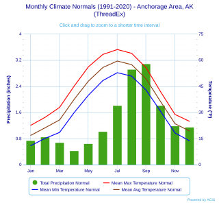
Anchorage, Alaska has a subarctic climate with the code Dfc according to the Köppen climate classification due to its short, cool summers. The weather on any given day is very unpredictable. Some winters feature several feet of snow and cold temperatures, while the summers are typically mild but are cool compared to the contiguous US and interior Alaska. Because of Anchorage's high latitude, summer days are very long and winter daylight hours are very short. The longest day of sunlight being 18hrs and 21 minutes, and shortest being 5 hours and 28 minutes. Anchorage is often cloudy during the winter, which decreases the amount of sunlight experienced by residents.
Chapel Beck is a minor river in the county of Cumbria in England.

Charles Warren Thornthwaite was an American geographer and climatologist. He is best known for devising the Thornthwaite climate classification, a climate classification system modified in 1948 that is still in use worldwide, and also for his detailed water budget computations of potential evapotranspiration.

A humid subtropical climate is a temperate climate type characterized by hot and humid summers, and cool to mild winters. These climates normally lie on the southeast side of all continents, generally between latitudes 25° and 40° and are located poleward from adjacent tropical climates. It is also known as warm temperate climate in some climate classifications.

Thornthwaite is a village in Cumbria, England. Historically in Cumberland, it is just off the A66 road, south of Bassenthwaite Lake and within the Lake District National Park. It is 3.5 miles (5.6 km) by road from Keswick. In 1861 the township had a population of 153. The place-name contains thwaite ("clearing").

The climate of New York City features a humid subtropical variety (Cfa), with parts of the city transitioning into a humid continental climate. (Dfa) This gives the city cool, wet winters and hot, humid summers with plentiful rainfall all year round. Meteorological records have been kept at Central Park since 1821, although the station was relocated to a different part of the park on January 1, 1920. There are also other weather stations in the area including one at LaGuardia Airport, beginning in 1940, and at JFK Airport, beginning in 1948. However, due to Central Park's long records and central location, it is often considered the main station for the city. Hence, all records unless otherwise stated will be for this station.
Porto and its metropolitan area feature a Mediterranean climate with mild wet winters and warm dry summers. According to the Troll-Paffen climate classification, Porto has a warm-temperate subtropical climate, and a subtropical climate according to Siegmund/Frankenberg. Porto is the wettest major city with a Mediterranean climate.
The Thornthwaite climate classification is a climate classification system created by American climatologist Charles Warren Thornthwaite in 1931 and modified in 1948.
Marie Elizabeth Sanderson was a Canadian geographer and climatologist.