
Cranston, formerly known as Pawtuxet, is a city in Providence County, Rhode Island, United States. The official population of the city in the 2020 United States Census was 82,934, making it the second-largest city in the state. The center of population of Rhode Island is located in Cranston. Cranston is a part of the Providence metropolitan area.
Knightsville is an urban neighborhood in the city of Cranston, Rhode Island.

Fiskeville is a small village in the south west corner of Cranston, Rhode Island, United States, the south east corner of the Town of Scituate, Rhode Island and across the northern side of Coventry, Rhode Island. The village's Main Street forms the border between Cranston and Scituate. Fiskeville grew up as one of several mill towns along the Pawtuxet River in the mid-1800s. The Fiskeville textile mill was formed by Dr. Caleb Fiske, a Revolutionary War doctor turned businessman in 1812. The village became home to those who worked in the mill, mostly immigrants from Portugal, France, Italy and England. Fiskeville is usually associated with Cranston rather than with Scituate as most of the original buildings including Dr. Fiske's residence were in Cranston. Although the mill and about a dozen nearby mill houses were in Scituate. Poets Karen Haskell and Darcie Dennigan both grew up, a few doors down from each other, in the 1970s and 1980s on Main Street in Fiskeville.
Auburn is an urban neighborhood in the east-central part of Cranston, Rhode Island.
Saint Paul School is a Catholic, co-educational, elementary school in Cranston, Rhode Island, United States. It serves students from the cities of Cranston, Warwick and Providence in Rhode Island, USA.
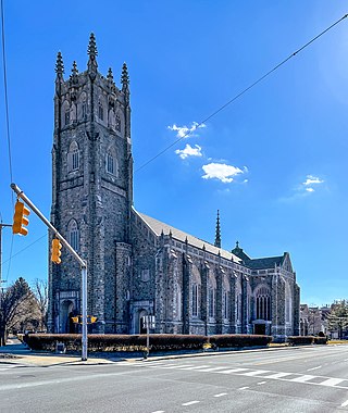
Saint Paul Church, located in Cranston, Rhode Island, is a church and parish of the Diocese of Providence.
Norwood is a neighborhood in the city of Warwick, Rhode Island. Norwood is bounded by Route 37, the Pawtuxet River, Elmwood Avenue, and Post Road. Such borders mark the area traditionally served by the fire station previously located at the current site of the Norwood Boys & Girls Club.

Rhode Island's 2nd congressional district is a congressional district in southern and western Rhode Island. The district is currently represented by Democrat Seth Magaziner, who has represented the district since January 2023.
Silver Lake is a neighborhood on the western edge of Providence, Rhode Island. It is bordered by the Hartford neighborhood to the north, Route 10 to the east, Johnston and Cranston on the West and separated from Olneyville by Route 6.
Upper South Providence is an official neighborhood in the South Side in the city of Providence, Rhode Island. It is bound to the north by Interstate 95, the east by the Providence River, to the south by Public Street, and the west by Broad Street. Often associated with Lower South Providence directly to its south, Upper South Providence is a distinct neighborhood.

The South Side of Providence, Rhode Island, originally South Providence, is a term frequently used to describe the collective region comprising the official neighborhoods of Upper and Lower South Providence, Elmwood and the West End. The name was first used in the 1830s when the New York, Providence and Boston Railroad established its first station at a pier on the Providence River on a point of land about one half mile south of downtown Providence. The station was named South Providence.
The Common Burying Ground and Island Cemetery are a pair of separate cemeteries on Farewell and Warner Street in Newport, Rhode Island. Together they contain over 5,000 graves, including a colonial-era slave cemetery and Jewish graves. The pair of cemeteries was added to the National Register of Historic Places as a single listing in 1974.
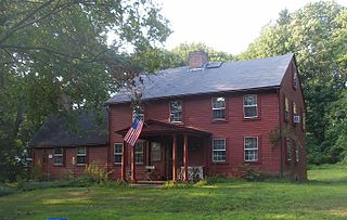
The Edward Searle House is an historic stone ender in Cranston, Rhode Island in the village of Oaklawn. The house is one of the oldest surviving buildings in the state.
Cranston Stebbins Stadium is a multi-use stadium complex located in Cranston, Rhode Island. It consists of Magciacomo Field, a baseball field, as well as Stebbins Field, an athletic field suitable for playing football, soccer, field hockey or lacrosse.

Interstate 895 was a proposed Interstate Highway in Rhode Island and Massachusetts that would have supplemented Interstate 295 to create a full beltway around Providence.
Graniteville is a village located within the town of Johnston, Rhode Island.
Frog City, Rhode Island is a village in Johnston, Rhode Island within another village of Thornton, Rhode Island and according to one source was "probably termed Frog City because of the numerous frogs along the Pocasset River and ponds near Victoria Mill at Mill Street and Victoria Mount." Frog City was bordered by Mill St. to the North, Plainfield St. to the East and South, and Rachela St. to the West.

Rhode Island Maximum Security Prison, formerly known as Howard Prison, is a Rhode Island Department of Corrections state prison for men located in Cranston, Rhode Island. It is the state's oldest operational prison, with a current capacity of 430.
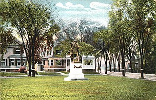
Columbus Square is a historic public square in the Historic Elmwood Neighborhood of Providence, Rhode Island. Located at the intersection of Elmwood Avenue and Reservoir Avenue, it serves as a gateway to Elmwood from the Reservoir and West End Neighborhoods.
Hughesdale is a neighborhood in the town of Johnston, Rhode Island. Hughesdale is a primarily residential neighborhood in the southeast corner of the town, centered near Central Avenue and Atwood Avenue. It is situated near the villages of Simmonsville and Thornton.
