
Southern California is a geographic and cultural region that generally comprises the southern portion of the U.S. state of California. It includes the Los Angeles metropolitan area, the second most populous urban agglomeration in the United States. The region generally contains ten of California's 58 counties: Imperial, Kern, Los Angeles, Orange, Riverside, San Bernardino, San Diego, Santa Barbara, San Luis Obispo and Ventura counties.
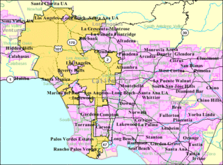
Greater Los Angeles is the second-largest metropolitan region in the United States with a population of 18.5 million as of 2021, encompassing five counties in southern California extending from Ventura County in the west to San Bernardino County and Riverside County in the east, with Los Angeles County in the center and Orange County to the southeast. According to the U.S. Census Bureau, the Los Angeles–Anaheim–Riverside combined statistical area covers 33,954 square miles (87,940 km2), making it the largest metropolitan region in the United States by land area. Of this, the contiguous urban area is 2,281 square miles (5,910 km2), the remainder mostly consisting of mountain and desert areas. In addition to being the nexus of the global entertainment industry, Greater Los Angeles is also an important center of international trade, education, media, business, tourism, technology, and sports. It is the 3rd largest metropolitan area by nominal GDP in the world with an economy exceeding $1 trillion in output.

Indio is a city in Riverside County, California, United States, in the Coachella Valley of Southern California's Colorado Desert region. It lies 23 miles (37 km) east of Palm Springs, 75 miles (121 km) east of Riverside, 127 miles (204 km) east of Los Angeles, 148 miles (238 km) northeast of San Diego, and 250 miles (402 km) west of Phoenix.

Thousand Palms is a census-designated place (CDP) in the Coachella Valley of Riverside County, California, United States. The population was 7,715 at the 2010 census, up from 5,120 at the 2000 census.

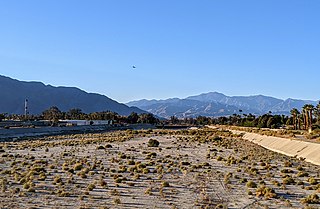
The Coachella Valley is an arid rift valley in the Colorado Desert of Southern California's Riverside County. The valley may also be referred to as Greater Palm Springs due to the prominence of the city of Palm Springs. The valley extends approximately 45 mi (72 km) southeast from the San Gorgonio Pass to the northern shore of the Salton Sea and the neighboring Imperial Valley, and is approximately 15 mi (24 km) wide along most of its length. It is bounded on the northeast by the San Bernardino and Little San Bernardino Mountains, and on the southwest by the San Jacinto and Santa Rosa Mountains.
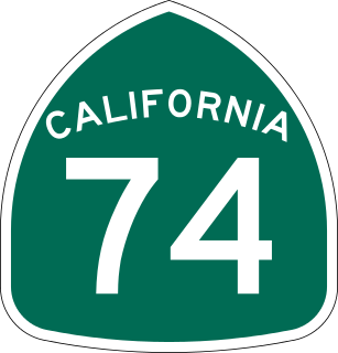
State Route 74, part of which forms the Palms to Pines Scenic Byway or Pines to Palms Highway, and the Ortega Highway, is a state highway in the U.S. state of California. It runs from Interstate 5 in San Juan Capistrano in Orange County to the city limits of Palm Desert in Riverside County. Stretching about 111 miles (179 km), it passes through several parks and National Forests between the Pacific coast and the Coachella Valley.
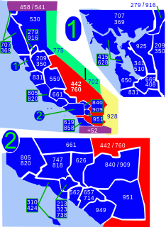
Area code 760 is a California telephone area code that was split from area code 619 on March 22, 1997. Area code 442 is an overlay of 760 that became effective on November 21, 2009. It encompasses much of the southeastern and southernmost portions of California. The area includes Imperial, Inyo, and Mono counties, as well as portions of San Diego, Riverside, San Bernardino, Los Angeles and Kern counties.
The Whitewater River is a small permanent stream in western Riverside County, California, with some upstream tributaries in southwestern San Bernardino County. The river's headwaters are in the San Bernardino Mountains and it terminates at the Salton Sea in the Colorado Desert. The area drained by the Whitewater River is part of the larger endorheic Salton Sea drainage basin.
Edom is the name given to Esau and the nation descending from him in the Hebrew Bible.

KPSC is a radio station licensed to serve Palm Springs, California. The station is owned by the University of Southern California, and is a repeater of KUSC and their classical music format.
The Indio Hills are a low mountain range in the Colorado Desert. located in Riverside County, California's Coachella Valley. The hills were named for their proximity to the city of Indio, and are sometimes referred to as the Indio Mud Hills or Indio Sand Hills.

SunLine Transit Agency, a transit operator in Riverside County, California, is a transit agency providing bus service in the Coachella Valley, with service extending into Downtown Riverside during peak hours. In 2021, the system had a ridership of 2,118,100, or about 7,000 per weekday as of the first quarter of 2022.

Coachella Valley National Wildlife Refuge is a 3,709-acre (15.01 km2) protected area in Riverside County, California's Coachella Valley. It lies within the unincorporated community of Thousand Palms, just north of Palm Desert. The refuge contains the majority of critical habitat for the Coachella Valley Fringe-toed Lizard within the Coachella Valley Preserve and Indio Hills Palms State Reserve.

Riverside County is a county located in the southern portion of the U.S. state of California. As of the 2020 census, the population was 2,418,185, making it the fourth-most populous county in California and the 10th-most populous in the United States. The name was derived from the city of Riverside, which is the county seat.
The Twenty-Nine Palms Band of Mission Indians of California is a federally recognized tribe of Mission Indians with two reservations, one located near the cities of Indio and Coachella in Riverside County, and the other in the city of Twentynine Palms in San Bernardino County, California. While many scholars regard the tribe as being Luiseño, the tribe itself identifies as being Chemehuevi.
Palm Canyon may refer to:

Eduardo Garcia is an American politician who represents the 56th Assembly District, which includes cities and unincorporated communities in eastern Riverside County and Imperial County, including Blythe, California, Brawley, California, Bermuda Dunes, Calexico, California, Calipatria, Cathedral City, California, Coachella, California, Desert Hot Springs, El Centro, Heber, Holtville, Imperial, Indio, California, Mecca, California, Oasis, North Shore, California, Salton City, California, Thermal, California, Thousand Palms, and Westmorland, California.

The Inland Empire (IE) is a metropolitan area and region inland of and adjacent to coastal Southern California, centering around the cities of San Bernardino and Riverside, and borders Los Angeles County to the west. It includes the cities of western Riverside County and southwestern San Bernardino County, and is considered to include the desert communities of the Coachella and Victor Valleys, respectively on the other sides of the San Gorgonio Pass and San Bernardino Mountains from the Santa Ana River watershed that forms the bulk of the Inland Empire; a much broader definition includes all of Riverside and San Bernardino counties. The combined land area of the counties of the Inland Empire is larger than ten U.S. states – West Virginia, Maryland, Hawaii, Massachusetts, Vermont, New Hampshire, New Jersey, Connecticut, Delaware and Rhode Island – and is slightly smaller than the combined area of the last five.
'Palm Canyon Wash may mean :
B Bar H Ranch, California is an unincorporated area with cultural and historical features and is a residential community in Riverside County, California. B Bar H Ranch is located between Palm Springs and Desert Hot Springs in the Seven Palms Valley. California Home Town Locator states the B Bar H Ranch Latitude is 33.9102927 and Longitude is -116.4819566. The GNIS entry date is January 19, 1981. B Bar H Ranch sits at an elevation of 784 feet (239 m). B Bar H Ranch is approximately eight miles north of Palm Springs, California and approximately six miles south of Desert Hot Springs, California. B Bar H Ranch's approximate 240 acres are bordered by 18th Avenue to the north, Mountain View Road to the east, 20th Avenue to the south, and Bubbling Wells Road to the west. B Bar H Ranch consisted of approximately 899 residents as of the 2010 US Census.