
Raritan Township is a township in Hunterdon County, New Jersey, United States. As of the 2010 United States Census, the township's population was 22,185, reflecting an increase of 2,376 (+12.0%) from the 19,809 counted in the 2000 Census, which had in turn increased by 4,193 (+26.9%) from the 15,616 counted in the 1990 Census. The township is located within the heart of the Amwell Valley and Raritan Valley regions, as the South Branch of the Raritan River flows through the center of the township. The northwestern portion of the township is located on the Hunterdon Plateau.

Readington Township is a township located in the easternmost portion of Hunterdon County, New Jersey, United States. As of the 2010 United States Census, the township's population was 16,126, reflecting an increase of 323 (+2.0%) from the 15,803 counted in the 2000 Census, which had in turn increased by 2,403 (+17.9%) from the 13,400 counted in the 1990 Census.
Riverside, New Jersey may refer to:

Robert Greifeld is an American businessman and was the chairman of Nasdaq, the largest electronic screen-based equity securities market in the United States. He served as CEO from 2003 to 2016 and was succeeded by Adena Friedman. Greifeld focused the NASDAQ-OMX mission on being the premier U.S equities market, leveraging NASDAQ-OMX's fundamental market structure advantage. He stepped down as Chairman in May 2017 to become Chairman of Virtu Financial.

Hunterdon Central Regional High School is a comprehensive, four-year public high school, and regional school district that serves students from five municipalities in east central Hunterdon County, New Jersey, United States. Students hail from Delaware Township, East Amwell Township, Flemington, Raritan Township and Readington Township.
The Readington Township Public Schools is a community public school district that serves students in pre-kindergarten through eighth grade from Readington Township, in Hunterdon County, New Jersey, United States.
Pleasant Run may refer to the following places in the United States:
The Delaware Township School District is a community public school district that serves students in pre-kindergarten through eighth grade from Delaware Township, in Hunterdon County, New Jersey, United States.

Holland Brook is a tributary of the South Branch Raritan River in Hunterdon and Somerset Counties, New Jersey in the United States.
The East Amwell Township School District is a community public school district that serves students in pre-kindergarten through eighth grade from East Amwell Township, in Hunterdon County, New Jersey, United States.
Readington Village is an unincorporated community located within Readington Township in Hunterdon County, New Jersey, United States, that is centered on the converging of Readington Road, Hillcrest Road, Centerville Road and Brookview Road. It is located on Holland Brook, originally named Amanmechunk, which means large creek in the Unami dialect. The area was inhabited by the Raritan prior to the arrival of European settlers. The Native Americans who lived near Readington Village travelled to the coast during the summer for fish and clams. Such a trip is mentioned in an Indian deed transferring lands around Holland Brook to George Willocks, an East and West New Jersey Proprietor. The deed mentions two of the natives, who lived at Readington: Metamisco and Wataminian.

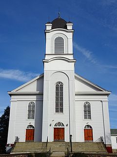
Stanton is an unincorporated community located within Readington Township in Hunterdon County, New Jersey, United States. The community dates back to the 17th century and was settled by the Dutch immigrants. It was originally called Housel's after Johannes Housel, who had a farmstead along Dreahook Road in the mid-18th century. After the death of William Housel, the last owner of the Housel farmstead, it then carried the name of Waggoner's Hill after landowner William Waggoner. The community took the descriptive name of Mount Pleasant in the early 20th century and would finally become known as Stanton to distinguish it from another Mount Pleasant. The name "Stanton" was taken from James Logan's Pennsylvania estate: Stenton, which in turn is named for the Scottish village where his father was born. Logan was a proprietor of West Jersey, a mayor of Philadelphia, and a Chief Justice of the Supreme Court of Pennsylvania. Logan Way in Readington is named after him, as well as Logan Circle and the Logan neighborhood in Philadelphia and Logan Township in Clinton County, Pennsylvania. In the 1830s, a Reformed Church and a general store were built. The Stanton Reformed Church still stands today while the Stanton General Store has been converted to an Italian restaurant called the Stanton Italian Table.
Potterstown is an unincorporated community along the border of Clinton and Readington townships in Hunterdon County, New Jersey.

Dreahook is an unincorporated community in Readington Township in Hunterdon County, New Jersey, United States at the intersection of CR-620/Dreahook Rd and CR 523. The name is a corruption of Driehoek, which is the Dutch word for triangle. It was likely named for the triangle created by the settlement in its relation to the early roads to Flemington, Whitehouse Station, Readington Village and Pleasant Run, which have since been rerouted. Dreahook Creek and Holland Brook both pass through the area of the former village. Dreahook village once had blacksmith shop, a school and a store. Settlers farmed the land here because of the rich soil along the base of Cushetunk Mountain. There are still numerous farms in the area, including the Readington River Buffalo Farm between Dreahook and Stanton.

Three Bridges is an unincorporated community located within Readington Township in Hunterdon County, New Jersey, United States, on the South Branch Raritan River. It is named for the three original bridges which crossed the river.
The Coxe–Barclay Line was a boundary line or partition line drawn through the Province of New Jersey during the colonial period, dividing it into the Province of West Jersey and the Province of East Jersey. Surveyor General George Keith surveyed a northwesterly partition line from Little Egg Harbor that veered too far to the west, and was stopped by the order of Dr. Daniel Coxe, the governor of West Jersey. Keith ended his line when he reached the South Branch of the Raritan River in what is now Three Bridges in Readington Township. Governor Coxe, and his East Jersey counterpart, Governor Robert Barclay met in London to set a compromise boundary following the South and North Branches of the Raritan River, the Lamington River, a straight line to the head of the Passaic River, along the Pompton and Pequannock Rivers, and then a straight line northeast to New Jersey–New York border. The East Jersey proprietors disowned this line in 1695 and it was formally rescinded by the colonial legislature in 1718.

Centerville was a hamlet within Readington Township in Hunterdon County, New Jersey, United States. The community was located along Campbell's Brook and Old York Road. Centerville grew up because of a tavern that marked the halfway point on the long Swift Sure Stage Line route from New York to Philadelphia. The hamlet had a school, a store, a post office, a church and blacksmith. When the railroads and newer roads were built, Centerville saw few visitors and today all the buildings there are residences.

Rockefellows Mills is an unincorporated community located within Raritan Township in Hunterdon County, New Jersey, United States. The settlement is located along the South Branch Raritan River near Three Bridges. The river is spanned in the area by the historic Rockafellows Mill Bridge built in 1900 and part of the Raritan–Readington South Branch Historic District. Most of the area within the Raritan Township side of the river is forested however on the north side of the river in Readington Township, some farmland dots the area.

Taylor's Mill Historic District, a 26-acre (11 ha) historic district featuring the gristmill Taylor's Mill, is located along Taylor's Mill Road and Rockaway Road near Oldwick in Readington Township, Hunterdon County, New Jersey. It was added to the National Register of Historic Places on June 11, 1992 for its significance in architecture, exploration/settlement, industry, and military. The district boundary was increased by 8 acres (3.2 ha) in 1997 to cross the Rockaway Creek and extend into Tewksbury Township.
The Raritan–Readington South Branch Historic District is a 556-acre (225 ha) historic district along River Road from New Jersey Route 31 to U.S. Route 202 near Flemington in Hunterdon County, New Jersey. It is primarily on the western side of the South Branch Raritan River in Raritan Township. It extends onto the eastern side of the river in Readington Township. County Route 523 and County Route 612 pass through the district to the north. The district encompasses the small settlements of Holcomb Mills, Flemington Junction, and Rockefellows Mills. It was added to the National Register of Historic Places on January 26, 1990, for its significance in architecture, politics, transportation, and exploration/settlement. The district includes 36 contributing buildings, four contributing structures, and three contributing sites. It also includes the John Reading Farmstead, previously listed on the NRHP individually.