
Kane County is a county in the U.S. state of Utah. As of the 2020 United States Census, the population was 7,667. Its county seat and largest city is Kanab.

Panguitch is a city in and the county seat of Garfield County, Utah, United States. The population was 1,725 at the 2020 census. The name Panguitch comes from a Southern Paiute word meaning “Big Fish,” likely named after the plentiful nearby lakes hosting rainbow trout year-round.

Alton is a town in northwest Kane County, Utah, United States. The population was 119 at the 2010 census, a decrease from the 2000 figure of 134.

Kanab is a city in and the county seat of Kane County, Utah, United States. It is located on Kanab Creek just north of the Arizona state line.

U.S. Route 89 is a north–south United States Numbered Highway with two sections, and one former section. The southern section runs for 848 miles (1,365 km) from Flagstaff, Arizona, to the southern entrance of Yellowstone National Park. The northern section runs for 404 miles (650 km) from the northern entrance of Yellowstone National Park in Montana, ending at the Canadian border. Unnumbered roads through Yellowstone connect the two sections. Before 1992, US 89 was a Canada–Mexico, border-to-border highway that ended at Nogales, Arizona, on its southern end.
In the Latter Day Saint movement, the United Order was one of several 19th-century church collectivist programs. Early versions of the Order beginning in 1831 attempted to fully implement the law of consecration, a form of Christian communism or communalism, modeled after the Community of goods of the early church of Jerusalem which had "all things in common". These early versions ended after a few years. Later versions within Mormonism, primarily in the Utah Territory, implemented less-ambitious cooperative programs, many of which were very successful. The Order's full name invoked the city of Enoch, described in Latter Day Saint scripture as having such a virtuous and pure-hearted people that God had taken it to heaven.

U.S. Route 89A is a 91.74-mile (147.64 km) north–south auxiliary U.S. highway in southwestern Kane County, Utah and northeastern Coconino County, Arizona in the southwestern United States. The highway is an old routing of U.S. Route 89 from Bitter Springs, Arizona to Kanab, Utah. The state of Arizona has designated this highway the Fredonia-Vermilion Cliffs Scenic Road. The highway is used to access the North Rim of Grand Canyon National Park and is known for the Navajo Bridge. Until 2008, the Utah portion was signed State Route 11. The route provides the only direct road connection between the Arizona Strip and the rest of Arizona.

The Arizona Strip is the part of Arizona lying north of the Colorado River. Despite being larger in area than several U.S. states, the entire region has a population of fewer than 10,000 people. Consisting of northeastern Mohave County and northwestern Coconino County, the largest settlements in the Strip are Colorado City, Fredonia, and Beaver Dam, with smaller communities of Scenic, Littlefield and Desert Springs. The Kaibab Indian Reservation lies within the region. Lying along the North Rim of the Grand Canyon creates physical barriers to the rest of Arizona. Only three major roads traverse the region: I-15 crosses the northwestern corner, while Arizona State Route 389 and U.S. Route 89A cross the northeastern part of the strip, and US 89A crosses the Colorado River via the Navajo Bridge, providing the only direct road connection between the strip and the rest of the state. The nearest metropolitan area is the St. George, Utah, metro area, to which the region is more connected than to the rest of Arizona.

Jacob Hamblin was a Western pioneer, a missionary for the Church of Jesus Christ of Latter-day Saints, and a diplomat to various Native American tribes of the Southwest and Great Basin. He aided European-American settlement of large areas of southern Utah and northern Arizona, where he was seen as an honest broker between Latter-day Saint settlers and the Natives. He is sometimes referred to as the "Buckskin Apostle", or the "Apostle to the Lamanites". In 1958, he was inducted into the Hall of Great Westerners of the National Cowboy & Western Heritage Museum.
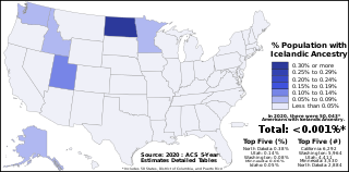
Icelandic Americans are Americans of Icelandic descent or Iceland-born people who reside in the United States. Icelandic immigrants came to the United States primarily in the period 1873–1905 and after World War II. There are more than 40,000 Icelandic Americans according to the 2000 U.S. census, and most live in the Upper Midwest. The United States is home to the second largest Icelandic diaspora community in the world after Canada.
Mills is the plural form of mill, but may also refer to:
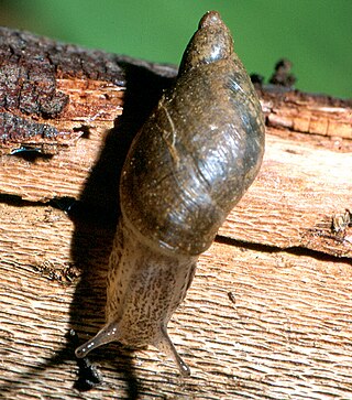
The Kanab ambersnail, formerly classified as Oxyloma haydeni kanabense or Oxyloma kanabense, is a small, air-breathing land snail belonging to the family Succineidae, the ambersnails. This terrestrial pulmonate gastropod mollusc was previously considered a critically endangered subspecies or species. In 2013, a scientific investigations report by the United States Geological Survey concluded that the Kanab ambersnail is not a genetically distinct species. In June 2021, the Fish and Wildlife Service removed the Kanab ambersnail from the United States Fish and Wildlife Service list of endangered mammals and birds and classified it with other common ambersnails within the same taxa, officially negating its status as a distinct subspecies.

Utah State Route 11 was a former state highway in southern and central Utah, United States that existed from 1910 to 2008. Although technically the same highway, because of the drastic change made to the route in 1977, there are two articles describing the former highway:
U.S. Route 89 in the U.S. state of Utah is a north-south United States Highway spanning more than 502 miles (807.891 km) through the central part of the state, making it the longest road in Utah. Between Provo and Brigham City, US-89 serves as a local road, paralleling Interstate 15, but the portions from Arizona north to Provo and Brigham City northeast to Wyoming serve separate corridors. The former provides access to several national parks and Arizona, and the latter connects I-15 with Logan, the state's only Metropolitan Statistical Area not on the Interstate.

Moqui Cave is a sandstone erosion cave in southern Utah, United States. It is located roughly 5 miles (8.0 km) north of Kanab, along U.S. Route 89.
Buckskin Mountain is a 16-mile (26 km) mountain ridge that spans from Coconino County, Arizona to Kane County, Utah in the United States, that is divided almost equally between the two counties.

The 2018 United States Senate election in Utah took place on November 6, 2018, to elect a member of the United States Senate to represent the State of Utah, concurrently with other elections to the United States Senate, elections to the United States House of Representatives, and various state and local elections. The primaries took place on June 26.
The 1901 Richfield earthquake was a magnitude 7.0 earthquake that occurred on 13 November 1901 at approximately 9:39 PM MST at Richfield, Utah, United States. If estimations are accurate, it is the largest earthquake ever recorded in Utah.